9/29/2010

Carte de la Coree 1865-1890

Tyo Syen朝鮮 Coree Per les Missionaires de Coree de la SOCIETE des MISSIONSETRANGERS (France) (circa 1865)
http://dokdo-or-takeshima.blogspot.com/2008/07/c1865-french-map-of-korea-coree.html

cc: same design: R. Hausermann's Map of Korea (1880)
http://dokdo-or-takeshima.blogspot.com/2008/05/1880-r-hausermanns-map-of-korea.html

Mer Du Japon
 
Detroit De Coree
Mer Jaune


also, same design
d'apres la Carte du Dictionnaire coreen-francais per les Missionaires de Coree Echelle (1890)
http://oldbooks.co.kr/main.html?menu=view&uid=664&category=%C1%F6%B8%AE%C1%F6%C1%FA-%C1%F6%B5%B531 (Cache
Mer Du Japon
Detroit de Coree
Mer Janue


I checked this map and I confirmed the existence of French-Corean dictionary.

Dictionnaire coréen-français par la Société des missions étrangères (1880)
http://www.archive.org/details/DictionnaireCoren-franais
http://www.archive.org/stream/DictionnaireCoren-franais/coreen_dictionnaire#page/n701/mode/2up

OUL-NEUNG-TO 蔚陵島 Ile sur la cote est de Coree
OU-SAN 于山 Ile a I'E . de la Coree, prés de Oul-neung-to.
(Ousan is Iland of Corea, next to (close distance) to Ulluengdo)
*Usually they dont say 90km distance is "prés de" but small distance (2km) do.


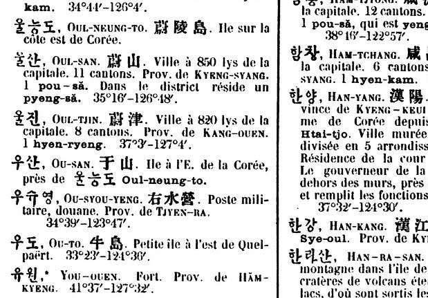
If they acknoledged the Usan is Takeshima(Liancourt Rocks) today, they would have written "It is Liancourt Rocks" on the dictionary. They doesnt consider "Ousan于山" is Liancourt Rocks.(French already recognized Liancourt Rocks around 1849 s by whale ship Liancourt and Frenc hydrographic office's Pilot magazine write Liancourt rocks on 1860's. )

1870.Carte de la Coree
Broughton bay:Goulf Broughton


1874. "Histoire de L'Eglise de Corée" by Claude Charles Dallet
http://dokdo-or-takeshima.blogspot.com/2008/05/1874-histoire-de-leglise-de-core-by.html
Mer du Japon
Detroit de Coree
Mer Jaune


P266(n277)
http://www.archive.org/stream/histoiredelegli00dallgoog#page/n277/mode/1up/search/japon

A L'embouchure du Mi-Kiang, pres de la mer du Japon, se trouve sur la frontiere de la Coree un boung tartare nomme Houng-tchoung, et chaque seconde annee, une foire considerable y reunit pendant quelques heures le peuple des deux pays limitrophes.


What? Korean claims "Sea of Japan" is colonialism name? Kidding. Korean is timetraveller? 1865-1890 Map of Corea also use Sea of Japan. Annexation of Korea is 1910.

1904.Dux Christus An Outline Study Of Japan

Dux Christus An Outline Study Of Japan (1904)
William Elliot Griffis
http://www.archive.org/details/duxchristusanout003078mbp

Attached Map
Sea of Japan;Japan Sea
East China Sea: Eastern Sea
http://www.archive.org/stream/duxchristusanout003078mbp#page/n9/mode/2up
(There are Ulleungdo ,described as ”Matsusima" on the sea of Japan too)


P51(P73)
China is heard of only very late in the story, but "the world" to the Kojiki myth-makers consists of the three great islands that we know, with a fre islets in the Japan Sea, that serverd as stepping stones from the continent.

http://www.archive.org/stream/duxchristusanout003078mbp#page/n73/mode/2up/search/east+sea

9/20/2010

9/16/2010

1872.瓜生氏日本国尽. 巻1-3 / 瓜生三寅 著

瓜生氏日本国尽. 巻1-3 / 瓜生三寅 著
http://www.wul.waseda.ac.jp/kotenseki/html/ru03/ru03_03604/index.html
明治5[1872] 名山閣, 東京府 序:佐藤誠

Attached map of Japan::日本海 Sea of Japan
http://archive.wul.waseda.ac.jp/kosho/ru03/ru03_03604/ru03_03604_0001/ru03_03604_0001_p0013.jpg1


9/15/2010

Greedy Korean try to steal not only Japan Sea but also Yellow Sea

Today I got to know Google Earth switches the name of the Sea of Japan and Yellow Sea for each language version.

See Japanese version you can see Sea of Japan and Yellow Sea-West Sea, and East (China) Sea.
Ofcourse there are no Japanese who call West sea instead of Yellow sea. Sea of Japan and Yellow Sea is globally established name.


In Chinese version there are wield two East Sea (Donghae(東海)) at the East China Sea(True East Sea) and at Sea of Japan (fake korean east sea)
In addition, there are Yellow Sea ofcourse. No (Korean fake) west sea there.


Korean version says Donghae, West Sea (Sohae) insteaad of Yellow Sea.
and it is strange that true East Sea (East China Sea) have "China" , but fake Korean East Sea have nothing "Korea" , just simple East Sea, which used to be East (China) Sea!
They doen't write not only Japan Sea and Yellow Sea!
What a unfair Google Earth?


Check other language version.
English version
Sea of Japan East sea/
Yellow Sea West sea
East China Sea


Francais
Mer du Japan Mer d Est 
Mer Jaune Mer de I'Ouest
Mer de Chine orientale

Espanol
Mer de Japon Mer del este
Mer Amarillo Mer Occidental
Mer de China Orientale

What is wield East Sea? Simply East Sea means East China Sea! It is not East Sea at the place of sea of Japan. also , what is West sea? Simply the sea is Yellow Sea, not West sea which korean claims.
Instead of East Sea and West Sea, there are East Korean gulf(東朝鮮湾) and West Korean gulf(西朝鮮湾), which is true "East or West Sea" in Korean language.

To decieve Japanese and Chinese and support Korean fascism like ethno-centrist propaganda, Google put sigle name on Sea of Japan at the Japanese version and on Yellow sea for Chinese version. But actually Google support Korean fascist propaganda and they put twin name on those seas.


Fake East (Korean) sea is not international hydrographic name.
The official name of Sea of Japan in International Hydrographic Office is "Japan Sea", not East Sea. In the same way, Official name of Yellow Sea is Yellow sea, not "West Sea" both of which Korean revisionist claims and spamms. Check S-23 publication of IHO.
http://sites.google.com/site/japanseamerdujapon/Home/-what-is-limits-of-oceans-and-seas-s-23-


50:Eastern China Sea (Tung Hai)
Mer du Chine Orientale.

51. Yellow Sea (Huang hai)
Mer Jenne

52 Japan Sea
Mer du Japon

This is Official international name.

Google earth must stop support Korean revisionist fasism propaganda against Sea of Japan and Yellow Sea! Google earth must stop commiting fascism propaganda by South Korean.

9/08/2010

1762.The general gazetteer, or, Compendious geographical dictionary

Those geographic Gazetter saids it is Sea of Japan.

The general gazetteer, or, Compendious geographical dictionary : (1762)

Brookes, R. (Richard), fl. 1750

http://www.archive.org/details/cihm_29855
It is interesting that the attached map shows "Sea of Korea" at the Sea of Japan space, but in the text they said it is Sea of Japan. It reminds me the case of Du Hadle's case. The atteched map of Royaume de Coree said "Mer du Coree" altough all the texts they use "Mer du Japon"(See my past post). So It can assumed that Mer du Japon was common at that time but some korean map use the sea of Korea? 

Attached map;Sea of Korea
http://www.archive.org/stream/cihm_29855#page/n5/mode/2up

Text:Sea of Japan
http://www.archive.org/stream/cihm_29855#page/n747/mode/2up/search/japan
Russia, the empire of , is a large country , partly in Asia, and partly in Europe, bounded on the N. by the Frozen Seal on the S. by Great Tartary, the Caspian Sea, and persial on the E. by the Sea of Japan, and on the W. by Poland and Sweden.


The general gazetteer : or, Compendious geographical dictionary containing a description of all the empires, kingdoms, states, republics, provinces, cities, chief towns, forts, fortresses, castles, citadels, seas, harbours, bays, rivers, lakes, mountains, capes and promontories in the known world : together with the government, policy, customs, manners, and religion of the inhabitants ... (1766)
Author: Brookes, R. (Richard), fl. 1721-1763; Adams, John, 1735-1826, former owner. BRL; Boston Public Library (John Adams Library) BRL
Publisher: London : Printed for J. Newbery ..., R. Baldwin ...
http://www.archive.org/details/generalgazetteer1766broo

attached map; Sea of Korea
http://www.archive.org/stream/generalgazetteer1766broo#page/n5/mode/2up

Text: sea of Japan
http://www.archive.org/stream/generalgazetteer1766broo#page/n357/mode/2up/search/japan
KAMSCHATKA, a large peninsuka, i the N. part of Asia, between the gulph...... the same name and the Sea of Japan.
http://www.archive.org/stream/generalgazetteer1766broo#page/n565/mode/2up/search/japan
Russia, the empire of , is a large country , partly in Asia, and partly in Europe, bounded on the N. by the Frozen Seal on the S. by Great Tartary, the Caspian Sea, and persial on the E. by the Sea of Japan, and on the W. by Poland and Sweden.


The general gazetteer; or, Compendious geographical dictionary (1786)
Author: Brookes, Richard, fl. 1750
Publisher: London J.F.C. Rivington
http://www.archive.org/details/generalgazetteer00broouoft

Text: the Sea of Japan
http://www.archive.org/stream/generalgazetteer00broouoft#page/n543/mode/2up/search/japan
Russia, the empire of, is a large country, partly in Asia, and partly in Europe:bounded on the N. by the Frozen Sea; on the S by Great Tartary, the Caspian Sea, and persia,; on the E; by the Sea of Japan; and on the W. by Poland and Sweden


The general gazetteer: or, Compendious geographical dictionary [microform] : containing a description of all the empires, kingdoms, states ... in the known world; together with the government, policy, customs, manners, and religion of the inhabitants; the extent, bounds, and natural productions of each country; and the trade, manufactures, and curiosities, of the cities and towns; their longitude, latitude, bearing and distance in English miles from remarkable places; as also the sieges they have undergone, and the battles fought near them : including an authentic account of the counties, cities, and market-towns in England and Wales; as also the villages, with the days on which the fairs are kept (1773)
Author: Brookes, R. (Richard), fl. 1750
Publisher: London : Printed for J. and F. Rivington, T. Carnan, and F. Newbery, junior [and 8 others]
http://www.archive.org/details/cihm_37414

text:sea of Japan
http://www.archive.org/stream/cihm_37414#page/n537/mode/2up/search/japan
Russia, the empire of, is a large country, partly in Asia, and partly in Europe:bounded on the N. by the Frozen Sea; on the S by Great Tartary, the Caspian Sea, and persia,; on the E; by the Sea of Japan; and on the W. by Poland and Sweden


General gazetteer, or, Compendious geographical dictionary (1795)
Author: Brookes, R. (Richard), fl. 1750
Publisher: London : Printed for B. Law [and 17 others]
http://www.archive.org/details/cihm_35441

Text: sea of Japan
http://www.archive.org/stream/cihm_35441#page/n631/mode/2up/search/japan
Russia, the empire of, is a large country, partly in Asia, and partly in Europe:bounded on the N. by the Frozen Sea; on the S by Great Tartary, the Caspian Sea, and persia,; on the E; by the Sea of Japan; and on the W. by Poland and Sweden


Brookes' general gazetteer abridged [microform] : containing a geographical description of the countries, cities, towns, forts, seas, rivers, lakes, mountains, capes, &c., in the known world; with their longitude and latitude, bearings and distances from remarkable places, and the events by which they have been distinguished (1796
)
Author: Brookes, R. (Richard), fl. 1750
Publisher: London : Printed for B. Law [and 24 others]

http://www.archive.org/stream/cihm_32554#page/n325/mode/2up/search/japan
KIRIN, one of the three departments of E Chinese Tartary, bounded on the N by th river Saghalien, on the E by the Sea of Japan, on the S by Corea, and o the W by Leaotong.
http://www.archive.org/stream/cihm_32554#page/n517/mode/2up/search/Russia
Russia, the empire of , is a large country , partly in Asia, and partly in Europe, bounded on the N. by the Frozen Seal on the S. by Great Tartary, the Caspian Sea, and persial on the E. by the Sea of Japan, and on the W. by Poland and Sweden.


The general gazetteer, or, Compendious geographical dictionary:(1797)
http://www.archive.org/details/cihm_17610

Attached map:Sea of Japan and Yellow Sea
http://www.archive.org/stream/cihm_17610#page/n7/mode/2up

Text explains Sea of Japan , and Bay of Corea (Today's Broughton bay)
http://www.archive.org/stream/cihm_17610#page/n363/mode/2up/search/japan
Kirin, one of the threee provinces of Eastern Tartary, bounded on the NW by the province of Tcitcicar, N by the river Saghalien, E by the Sea of Japan, S by Korea and Lenotong, and W by Western Tartary. This country, which is exremely cold, from the number of forests by which it is covered, is thinly inhabited.

http://www.archive.org/stream/cihm_17610#page/n571/mode/2up/search/japan
Russia, the empire of , is a large country , partly in Asia, and partly in Europe, bounded on the N. by the Frozen Seal on the S. by Great Tartary, the Caspian Sea, and persial on the E. by the Sea of Japan, and on the W. by Poland and Sweden.

http://www.archive.org/stream/cihm_17610#page/n57/mode/2up/search/Corea
Amour, a river of Asia whose source is in Siberia; it runs E through Chinese Tartary, and falls into the bay of Corea


The General gazetteer, or, Compendious geographical dictionary : (1801)
http://www.archive.org/details/cihm_17957

Attached map; Sea of Japan
http://www.archive.org/stream/cihm_17957#page/n7/mode/2up

Text:Sea of Japan and Bay of Corea (Today's Broughton bay)
http://www.archive.org/stream/cihm_17957#page/n593/mode/2up/search/japan
RUSSIA, a large empire, partly in Asia, and partly in Europe; bounded on the N by the Frozen Ocean ; on the S by Great Tartary, the Caspian Sea, and Persia ; on the E by the Sea of Japan; and on the W by Sweden, Poland, and the Black Sea.

http://www.archive.org/stream/cihm_17957#page/n47/mode/2up/search/corea
Amour, a river of Asia whose source is in Siberia; it runs E through Chinese Tartary, and falls into the bay of Corea


Brooke's general gazetteer improved, or, A new compendious geographical dictionary : (1806)
http://www.archive.org/details/cihm_29789

The attached map; Sea of Japan and Strait of Corea
http://www.archive.org/stream/cihm_29789#page/n5/mode/2up

Text:Sea of Japan
http://www.archive.org/stream/cihm_29789#page/n657/mode/2up/search/japan
Russia, the empire of , is a large country , partly in Asia, and partly in Europe, bounded on the N. by the Frozen Seal on the S. by Great Tartary, the Caspian Sea, and persial on the E. by the Sea of Japan, and on the W. by Poland and Sweden.


The general gazetteer, or, Compendious geographical dictionary : (1809)
http://www.archive.org/details/cihm_32443

Attached Map; Sea of Japan
http://www.archive.org/stream/cihm_32443#page/n7/mode/2up

Text: sea (and isles) of Japan ,Yellow Sea
http://www.archive.org/stream/cihm_32443#page/n209/mode/2up/search/japan
Corea, a peninsula of Asia, exending between China and Japan,; bounded on the N by Eastern Tartary, E by the sea and isles of Japan, S by the ocean, and W by the Yellow sea and Leao-tong.
http://www.archive.org/stream/cihm_32443#page/n415/mode/2up/search/japan
Kirin, one of the threee provinces of Eastern Tartary, bounded on the NW by the province of Tcitcicar, N by the river Saghalien, E by the Sea of Japan, S by Korea and Lenotong, and W by Western Tartary. This country, which is exremely cold, from the number of forests by which it is covered, is thinly inhabited.


Brookes's General gazetteer improved; or, A new and compendius geographical dictionary; (1812)
Author: Brookes, R. (Richard), fl. 1721-1763
Publisher: Published by Johnson and Warner, Philadelphia, and Richmond, Virginia
http://www.archive.org/details/brookessgeneral01broogoog

attached map: unable to confirm.
http://www.archive.org/stream/brookessgeneral01broogoog#page/n7/mode/2up
Text: Sea of Japan
http://www.archive.org/stream/brookessgeneral01broogoog#page/n589/mode/2up
Russia, the empire of , is a large country , partly in Asia, and partly in Europe, bounded on the N. by the Frozen Seal on the S. by Great Tartary, the Caspian Sea, and persial on the E. by the Sea of Japan, and on the W. by Poland and Sweden.


The general gazetteer, or, Compendious geographical dictionary :(1815)
http://www.archive.org/details/cihm_34755

Attached map Sea of Japan.
http://www.archive.org/stream/cihm_34755#page/n9/mode/2up

Text:Sea of Japan ,Yellow Sea
http://www.archive.org/stream/cihm_34755#page/n225/mode/2up/search/Corea
Corea, a peninsula of Asia, exending between China and Japan,; bounded on the N by Eastern Tartary, E by the sea and isles of Japan, S by the ocean, and W by the Yellow Sea and Leao-tong.

http://www.archive.org/stream/cihm_34755#page/n439/mode/2up
Kirin, one of the three provinces of Eastern Tartary, bounded on the NW by the province of Tcitcicar, N by the river Saghalien, E by the Sea of Japan, S by Corea and Leaotong, and W by Western Tartary.


Brookes' general gazetteer improved, or, Compendious geographical dictionary in miniature (1815)
http://www.archive.org/details/cihm_35439
Text:Sea of Japan
http://www.archive.org/stream/cihm_35439#page/n405/mode/2up/search/japan
Russia, A large empire, partly in Asia, and peartly in EUrope; bounded on N by the Frozen Ocean; on the S by Great Tartary, the Caspian Sea and Persia; on the E by the sea of Japan; and on the W by Sweden,, Poland, and the Black Sea.


The general gazetteer; or, Compendious geographical dictionary (1820)
Author: Brookes, Richard, fl. 1750
Publisher: London F.C. and J. Rivington
http://www.archive.org/details/generalgazette1820broouoft

Text: sea of Japan.
http://www.archive.org/stream/generalgazette1820broouoft#page/n343/mode/2up/search/japan
Japan, an empire , in the most eastern part of Asia, composed of three considerable and a great number of small islands, separated from Corea and China , by the strait of Corea and the sea of Japan, and extending from lon. 131 to 142E, and from lat. 30 to 41N.

http://www.archive.org/stream/generalgazette1820broouoft#page/n385/mode/2up/search/japan
Kirin, one of the three provinces of Eastern Tartary, bounded on the NW by province of Tcitcicar, N by the river Saghalien, E by the sea of Japan, s by Corea and Leao-tong, and W by Western Tartary.


The general gazetteer; or, Compendious geographical dictionary (1821)
Author: Richard Brookes
Publisher: printed for J. Bumpus ... [et al.]
http://www.archive.org/details/ageneralgazette00broogoog

Text: the sea of Japan
http://www.archive.org/stream/ageneralgazette00broogoog#page/n174/mode/2up/search/japan
Corea, a kingdom of Asia, bounded on the N by Chinese Tartary, on the E by the sea of Japan aon the S by a narrow sea, which separates it from the Japanese isalnds, and on the W by the Yellow sea, which separates it from China.
http://www.archive.org/stream/ageneralgazette00broogoog#page/n352/mode/2up/search/japan
Kirin, one of the three provinces of Eastern Tartary, bounded on the NW by province of Tcitcicar, N by the river Saghalien, E by the sea of Japan, s by Corea and Leao-tong, and W by Western Tartary.


The General Gazetteer, Or, Compendious Geographical Dictionary, in Miniature ... (1823)
Author: Richard Brookes, A . Picquot
Publisher: Printed for G. and W. B. Whittaker
http://www.archive.org/details/generalgazettee00picqgoog

Text: Sea of Japan
http://www.archive.org/stream/generalgazettee00picqgoog#page/n312/mode/1up/search/japan
Russia, a large empire, partly in Asia and partly n Europe, bounde on the N by the Frozen Ocean; on the S by Great Trartary, the Caspian Sea, and persia; on the E by the sea of Japan, and on the W by Sweden, ploand, and the Black Sea.


Dictionary of geography,(1834) Conder, Josiah
http://www.archive.org/details/dictionaryofgeog00cond

Text:Sea of Japan
http://www.archive.org/stream/dictionaryofgeog00cond#page/172/mode/2up
Corea A country of Eastern Asia. tributary to China, consist- ???hietly of large peninsula. separating the Yellow Sea and the Sea of Japan, and extending about 400 miles in length , etween N. ?4' and 40'.

http://www.archive.org/stream/dictionaryofgeog00cond#page/332/mode/2up/search/Corea
Japan. An empire of Asia, extending over three large island and a number of smaller ones, which are separeted from the peninsula of Corea, and the coast of Chinese Tartary, by the strait of Corea and Sea of Japan.they lie between the paralels of 30" and 41'N.

Text: Sea of Japan , Yellow Sea.
http://www.archive.org/stream/dictionaryofgeog00cond#page/582/mode/2up/search/japan
SEA A paticular part of division of the ocean, circumscribed
land, and generally taking the name from the counry which it wash
as the Arabian Sea, the Mexican Sea, $c., or from some paticular property.
The terms sa is sometimes used as synonymous w...
ocean , and is applied to the waters of the globe, in contradistinct.....
from the land. In its specific acceptation, it usually denotes
land ocean, as the Caspian; a gulf , as the Red Sea; or a divisi.....
of the ocean nearly enclosed by Land, as the Mediterranean. T.......
principal seas are:
In Europe.....
In Asia. The Caspian sea and the Sea of Aral. dividing Asia....
Russia from Persia and Tartary. The Red Sea or Arabian Gulf...
The Persian Gulf, sometimes called the Sea of Omaun and the Gre....
Sea. The Sea of Bengal. The China Sea. The Yellow Sea. The
Sea of Japan. The Sea of Okotsk. The Sea of Kamtchatka.


The Graphic atlas and gazetteer of the world (1892) Bartholomew, J. G. (John George), 1860-1920

http://www.archive.org/details/graphicatlasgaze00bart

Attached map: Sea of Japn ,Yellow Sea
http://www.archive.org/stream/graphicatlasgaze00bart#page/n17/mode/2up

http://www.archive.org/stream/graphicatlasgaze00bart#page/208/mode/2up/search/japan
Possiet Bay, Asiatic Russia, on W. coast of Sea of Japan.


by the way I checked ; A geographical dictionary : (1688) http://www.archive.org/details/cihm_29818

I didnt fiund neither Sea of Japan nor sea of korea
http://www.archive.org/stream/cihm_29818#page/n359/mode/2up

1837.North-Pole centralized map of the world.(極中心世界地図)

I asked to the Kobe City Museum about the map of North-Pole ccentralized map of the world.(極中心世界地図) published on 1837 (Japan edo-era Tempotenn 天保8)and they replies as follows;


Asking to the curator of the Kobe City Museum, the description on the map as follows;
Sea of Japan describes Sea of Japan/Yatsuhon-kai(Japon Sea)
East China Sea is 支那海”China Sea"
At the Korean strait there describes something, but it is unable to read it because too small.

Thank you Kobe Museum!

The map image of the website of Kobe city museum (but it is not clear so I asked them about hte detailed descriptions of hydrographic name)

http://www.city.kobe.lg.jp/culture/culture/institution/museum/meihin/033.html

1851.A directory for the navigation of the Pacific Ocean

A directory for the navigation of the Pacific Ocean; with description of its coasts, islands, etc., from the Strait of Magalhaens to the Arctic Sea, and those of Asia and Australia; its winds, currents, and other phenomena .. (1851)
by Findlay, Alexander George, 1812-1875
Fellow the Royal geography society.

Attached map; Sea of Japan
http://www.archive.org/stream/adirectoryforna02findgoog#page/n7/mode/1up

http://www.archive.org/stream/adirectoryforna02findgoog#page/n669/mode/1up/search/japan
The only river falling into this vast basin in the Amour, iif indeed the Amour can fairly be said to do so, terminationg as it does in a bay, which, being bounded in front by the Island or Peninsula of Saghalin, opens by one strait into the Sea of Okhotuk, and perhas by anther into the Sea of Japan.

Strait of Corea
http://www.archive.org/stream/adirectoryforna02findgoog#page/n697/mode/1up/search/Corea

Tides, Magnetic variations &c
http://www.archive.org/stream/adirectoryforna02findgoog#page/n54/mode/1up
Island of Nippopn:
N.E. cape
.....
.....
.....
.....
Dagelet island (Matsu sima) 37 25 130 56 La Perouse
Argonaut island (Take sima) 37 52 129 50  〃


A general gazetteer, or, Compendious geographical dictionary [microform] : containing descriptions of every country in the known world: with their towns, people, natural productions, &c., and the various remarkable events by which they have been distinguished : the population and area of all nations are also given in an appendix, including the census of Great Britain in 1861 (1865)

Brookes, R. (Richard), fl. 1750; Findlay, Alexander George, 1812-1875

http://www.archive.org/stream/cihm_17611#page/n305/mode/2up
COREA, a kingdom of Asia, bounded on the N. by Chinese Tartary, on the E. by the sea of Japan, on the S. by a narrow sea, which separeates it from the Japanese islands, and on the W. by the Yellow Sea, which separates it from China. The W. coast is flanked by innmerable islands............................................Corea extends from N.to S. from the lat. of 34.30 to 42.30.N. and from E. to W. from 125. to 129. of E. long.

http://www.archive.org/stream/cihm_17611#page/n327/mode/2up/search/japan
Dagelet island, and island about 9 miles in circumference, in the Japanese Sea, at about an equal distance from the Isle of Nippon and the coast of the Corea, in the lat. of 37.25.N. It was visited by La Perouse. It abounds with timber, which the Coreans are supposed to use in the building of boats.

http://www.archive.org/stream/cihm_17611#page/n547/mode/2up/search/japan
KIRIN, a government of Eastern Tartary; enclosed between the sea of Japan, the northern frontier of Corea, and the river of Saghalien.The emperror of China sends hither the criminals banished by the laws.


directory for the navigation of the North Pacific Ocean [microform] : with descriptions of its coasts, islands, etc., from Panama to Behring Strait and Japan, its winds, currents, and passages (1870)
http://www.archive.org/details/cihm_14979b

Attached map said "Japan Sea"
http://www.archive.org/stream/cihm_14979b#page/n3/mode/2up
http://www.archive.org/stream/cihm_14979b#page/n1069/mode/2up/search/japan

P683.
http://www.archive.org/stream/cihm_14979b#page/n683/mode/2up/search/japan
The Seto Uchi was first navigated by H.M.S. Cruizer, in 1859, and it was passed throughout bythe allied fleet under Admiral Sir A.L.Kuper, in 1864.It contains upwards of 300 islands and rocks, with but few known dangers, and has a sea-board of nearly 700 miles, on which are situate numerous large towns and several of the provincial capitals. It abounds with safe and convenient anchorages. It communicates with the Pacific by the Kii Channel on the East, and by the Bungo Channel, between Kiusiu and Sikok, on the South; and with the Sea of Japan by the Strait of Simonoseki on the West.

http://www.archive.org/stream/cihm_14979b#page/n1057/mode/2up/search/japan
Sea of Japan. There exists at present but little information regarding the navigation of the Sea of Japan. The winds there appear very available, and the currents, depending on special causes, are at times insignificant, whilst at others they run with great strength. The only thing known with certainty is, that the Japan Stream, as a rule (although with many variations of velocity, direction , and breadth, and much influenced by the wind), holds its way north-eastward from Korea Strait, and enters the Pacific by the Strait of Tsugar ; also that a stream is usually found in the autumn months setting to the E.S.E. through La Perouse Strait ; and in the summer along the coast of Manchuria to the S.W.

This description is almost matching with S-23 which definiation of Sea of Japan.
S-23 52.-Japan Sea/ On the Southwest The Northeastern limit of the Eastern China Sea (50) and the Western Limit of the Inland Sea (53. On the Southeast In Simonoseki Kaikyo A line running from Nagoya Saki (130"49'.05E) in Kyusyu through the island of Uma Sima and Muture Sima (33"58'05 N) to Murasaki Hana (34"01' N) in Honsyu. On the East In the Tsugaru Kaiko From the extremity of Siraya Saki (141"28' E) to the extremity of Esan Saki (41"48' N) On the Northeast In La Perouse Strait (Soya Kaikyo)    (Click here on google map) A line joining Soni Misaki and ishi Notoro Misaki (45"55' N) On the North From Cape Tuik (51"45.7 N) to Cape Suchcheva.


another description of Sea of Japan
http://www.archive.org/stream/cihm_14979b#page/n769/mode/2up/search/japan
http://www.archive.org/stream/cihm_14979b#page/n1027/mode/2up/search/japan

Strait of Corea
http://www.archive.org/stream/cihm_14979b#page/n679/mode/2up/search/corea


1878.A directory for the navigation of the Indian Archipelago, China, and Japan, from the straits of Malacca and Sunda, and the passages east of Java.(1878)
See the old post. Attached map: the Sea of Japan
http://www.archive.org/stream/directoryfornavi00find#page/n7/mode/2up

A directory for the navigation of the North Pacific Ocean [microform] : with descriptions of its coasts, islands, etc., from Panama to Behring Strait and Japan, its winds, currents, and passages (1886)
http://www.archive.org/details/cihm_14978

Attached map Sea of Japan
http://www.archive.org/stream/cihm_14978#page/n3/mode/2up
http://www.archive.org/stream/cihm_14978#page/n5/mode/2up

Sea of Japan;(P915/N1065)
http://www.archive.org/stream/cihm_14978#page/n1065/mode/2up/search/oliv

The SEA of JAPAN, bounded on the East and South by the Japanese Archipelago, and on the West and N.W. by the coast of Korea and Russian Tartary, is about 900 miles long. N.N.E and S.S.W....,and 600 miles wide.East and West, at its broadest part. As far as is known, it is of rocks or dangers, with the following exceptions;
Liancourt Rocks were discovered by the French ship Liancourt, in 1849; they were also called Menalai and Olivutsa Rocks by Russian frigate Pallas, in 1854; and Hornets Islands by H.M.S Hornet, in 1855. Captain Forayth, of the letter vessel, gives their position as lat. 37'14N., long. 131"55 E., and describes them as two rocky islets, covered with guano, extending about 1 mile N.W. by W. and S.K by E., and apparently joined by a reef. The western islet, about 410ft, high, has a sugar-loaf form; the eastern is much lower, and flat-top ped.
MATSU SIMA, or Dagelet Island, is a collection of sharp conieal wooded hills, crowned by an imposing peak, 4000ft. high, is the centre, in lat. 37 30 N., long. 130 53'E. It is 18 miles in circumferences, and there are several detached high rocks along its ashores, some reaching an elevation of 400 to 500 ft. The shores are so steep that soundings could only be obtained by the Actaeon's boats, almost at the base of the cliffs. Landing may be effected in fine weather with difficulty. In spring and summer some Koreans reside here, and build junks; they also collect and dry large quantities of shell-fish.
Waywoda Rock is mid to have been discovered by the Russian corvette Waywoda. It appeared to be 12ft. high,. 70ft broad, and its approximate position is lat. 42 14 1/2N long 137 17E
Tsushima....................................................................................

Movie:Landing on Boussoule Rock-Jukdo(Usando)


2009年の08月に鬱陵島に行って、竹嶼に上陸して映像を取ってきました。
自分のCamcorderはかなり前に壊れてしまい、仕方なく韓国人の知人のSamsungの少し古いCamcorderを使ったためか、大変画像が汚い。 また、一眼レフカメラを持って行ったのですが、初日早々からフィルムを巻くモーターみたいなのが壊れていた様で、それに気が付かずつかっていましたが気が付いたのがほぼ欝陵島滞在終盤に差し掛かってのことで、写真は碌に取れていませんでした・・・。Panoramioにいくつか、一部写真(http://www.panoramio.com/user/197550)がありますが、これは知人のSonyのデジタルカメラを借りてたまたま予備として撮影したものです。

On August 2009 I had been to Ulluengdo (Dagelet) and Jukdo(Boussoule rock/Usando). Landing on Jukdo and took movie by Camcorder. My film camera had broken at the
Ulluengdo so I couldt took enough picture.....

After landing on jukdo I convinced that this Jukdo is Usando on korean antique maps,which is most prominent adjuctive island of Ullengdo , narrow wide shape one island.
https://sites.google.com/site/takeshimaliancourt/Home/chousen-ouchou-no-yu-lingtou-
sou-taokan-no-seisaku-shi-ta-yu-lingtou-shousai-zu

and..check dokdo or takeshima by Gerry Bevers;http://dokdo-or-takeshima.blogspot.com/


竹嶼を最初に見たのは、ついた初日に乗った鬱陵島一周観光船からでした。


竹嶼に上陸して感じたことは、この島は、地図の大きさ以上に、大きな島に感じます。
と いうのは、 鬱陵島というのはもちろん大きい島なのですが、意外と、利用できる範囲に限りがあります。山がちな島で、谷間と河口に居住空間があるのみで す。それに加え、竹嶼は、意外と活用できる空間が広いことにあります。私見ですが、家十軒を立てて100人を養う広さがあります。それゆえ、上陸してみ て、地図上の大きさよりも大きな島のような錯覚を受けました。

また、鬱陵島の東岸から竹嶼までは、大体2km位と言われます。2Kmというと、なんだ、結構近いな、と考えがちですが、実際そうでもなく、意外と遠いんですね。
2Kmくらいなら私も水泳やっていたとき泳いでいたので、楽勝だと思うのですが、この東岸と竹嶼のあいだは、波が荒いので注意が相当必要なうえ、とても泳いでいくような環境にはありません。

鬱陵島本島とは、明らかに別界であるのが竹嶼であります。また、この島は鬱陵島を構成する中でも別格の島です。まあ、観音島もそこそこ大きいことは大きいのですが、やはり竹嶼の有効スペースはこれ顕著なものがあります。
この竹嶼の中には、海長竹(女竹)が生い茂っているのは1711年の朴易錫製作の鬱陵島図形そのとおり(于山島海長竹田)でした。(Video part2参照) また、芋が植えられていたりします。于山島が地図によっては、「芋山島」と呼ばれているのも偶然ではないように思えます。
そして、この竹嶼の北側には、階段があり、そこは山になっています。(Seeking for Usando,Ullengdo’s jukdo part 2 3;00付近以降)
*Part2* Landing on Jukdo


(画像:藪太郎氏 藪太郎の研究室から引用)
この様子は金正浩作成の青 図に描かれた位置とほぼ同様でした。改めて藪太郎氏の検証が正しく、日本系韓国人の保坂や韓国側の主張がいかに誠意が無く、ウソ・欺瞞に満ち溢れているか、再確認できました。藪太郎氏の指摘している古地図における赤い部分の小山が、実際に竹嶼にありました。
http://outdoor.geocities.jp/yabutarou01/a/newpage2.html

観音島については、すでに島根の竹島研究所に報告したのですが、観音島は昔は有人島だったとの事です。たぶんこの話は日本国内で私が最初にもたらした新情報のはずです。 全くの無人島だと思われていたこの島だが、20数年前までは、観音島には、三名の住民がいたとの事。。住民は、観音島で、ウサギとヤギを放し飼いにして それを飼育し、売っていたとのこと。 一時的に、ケーブルがかけられて運搬手段として使用されていたとのことだ。 当初は、橋を建築する計画が会ったのだ が、政府から計画の中止を宣告され、予算が下りず、計画は消滅したとのことである。昔は所有者が別個にいたらしいが、はっきりとは判らないが、現在は政府 の所有地らしい。
これは、天府および羅里の住民三名からの証言です。
この内容はすでに島根県側に報告しましたそのやり取りが、以下の内容です。
http://www.pref.shimane.lg.jp/soumu/web-takeshima/takeshima08/2007/record200908.html

【質問3】

   鬱陵島でバスドライバーから、観音島には過去に人が三人住んでいたと聞いた。ウサギとヤギを放し飼いにしていた、育ったウサギとヤギを売ると きに鬱陵島本土へケーブルを使って運搬していた、橋の建設計画があったが予算が下りずに頓挫してしまった、20数年前の話だ--とのことであった。これら の話を裏付ける当時の資料があるだろうか。

<回答>   李泳熙「独島・鬱陵島踏査記」『山(The San)』1971年9月号pp.24-31に、観音島について、「もともと無人島であったが泉があるため昨年一軒の農家が入った。」という記述がありま す(p.31)。また、孫成祐編『韓国地名辞典』〔ソウル〕景仁文化社1974年の観音島の項(p.63)に、「家口1。人口4。...住民は農業に従事 している」云々とあります。鬱陵島周辺の島嶼は、ほとんどが単なる岩礁である中、竹嶼(韓国で竹島=チュクトと呼ぶ島)と観音島が人の住める島であり、特 に名を挙げるならこの二島であるわけです。鬱島郡の区域を「鬱島全島と竹島石島」とした1900年の大韓帝国勅令第41号にいう竹島石島は(独島とは関係 なく)竹嶼と観音島ではないかという議論がありますが、観音島に実際に人が住んでいた事実は、この議論との関係で興味深いことです。(事務局:総務課)


で、皆さんが興味があるのは、竹島が鬱陵島から見えるか?という話だと思いますが、私は6泊7日鬱陵島にいき、三度聖人峰に登り、石圃展望台に三度、乃守田展望台に一度行きましたが、見えませんでした。 石圃にかんして、それどころか、私が行った日のうち、一日はあいにく雲がかかっており、東を望んだら、竹島はおろか、竹嶼も観音島も雲で見ることが出来なかったことがありました。(映像あり:Jukdo invisible from Seokbo observatory in cloudy)。石圃には三度行ったが、石圃からは三日とも島根の竹島を見ることが出来なかった。これは、鬱陵島は海岸から急に山の斜面が切り立っているため、海からの温かい風が山に当たって、比較的高度の低い位置(100~200m)で雲や霧がかかりやすく、、標 高の高い石圃(300-400m)から、低い地点を見下ろすと、雲の関係で竹嶼が見えない状況でした。 ちなみに、別の日に乃守田)といっても、芋田の一部で、北 芋田と考えたほうが適切)から竹嶼と観音島を見ることが出来たが、竹島は石圃と同様に見ることが出来なかった。ただし、曇っていない日はもちろん竹嶼は見えました。

 竹島についてですが、私は6泊7日の滞在中、一度も観ることはできませんでした。 ただし、超快晴の日(鬱陵島・海上・竹島近 海ですべて雲がかかっていない状態)であると竹島が見える可能性は有ります。 現地人バスドライバーいわく、竹島が見えるのは本当に例外で運がいいときだけ。年間20日程度だろうとの事で、見えることは見えるそうです。 標高計算上も見えるとの結果は出ています。
 ただし、韓国が歴史的根拠として主張する、「與地勝覧に鬱陵島から竹島が見えるとかいてるから、竹島はウサン島であり、韓国領土」というのは嘘で、與地勝覧にはそのような記述はありません。與地勝覧には「半島東岸から鬱陵島とウサン島の二島が見える、」と書いているだけであり、鬱陵島から竹島の眺望に関しては記載が全くありません。
見える見えないの議論は朝鮮半島東岸がら鬱陵島が見えるという意味で、鬱陵島から現竹島が見えるという意味ではない
また、先に述べたとおり、ウサン島は、朝鮮の王の命令で鬱陵島に調査に行って製作された一連の鬱陵島詳細地図の結論から、竹嶼で間違いないです。


*Part1* From Dodong harbour to Jukdo via southeast cape.


*Part2* Landing on Jukdo


*Part3* Landing on Jukdo


*Ulljuengdo boat tour norteast of Ulluengdo*


Jukdo cannot be seen from Seokbo(Northeast of Ulluengdo) in cloudy

1895.Great Korean Imperial taught Sea of Japan in their textbooks.

Revisionist Korean claims with distorture that "Sea of Japan" is colonial name which the name Japan forced Korea under annexation after 1910. But..It is obvious the claim is wrong because Daehan Imperial (Great Korean Imperial/大韓帝國) taught it Sea of Japan(日本海) in the school textbooks!

I already introduced some Korean geography text books on my past posts, this morning I found new description of "Sea of Japan"(日本海) in Great Korean Imperial (大韓帝国)govermental textbook!

Title: 小學 萬國地誌  
Author:學部編輯局編 Ministery of education text edit
Date 1895~1895
http://yoksa.aks.ac.kr/jsp/aa/ArticleList.jsp?mode=&page=1&fcs=&fcsd=&cf=&cd=&gb=&aa10up=kh2_je_a_vsu_B15AA^2_000&aa10no=kh2_je_a_vsu_B15AA^2_001&aa15no=&aa20no=&gnd1=&gnd2=&keywords=&rowcount=10

Chapter;Japan
http://yoksa.aks.ac.kr/jsp/aa/ImageView.jsp?aa10no=kh2_je_a_vsu_B15AA^2_001&aa20no=B15AA^2_001_0005

日本
太平洋西北隅X有X五大島X多数X小
島XXXX北X北海道X宗谷海峡X千島X又
?里海峡XXX界XX西北X日本海X隣X、X
西隅X朝鮮海峡X隔XX朝鮮X相對XX東南
一面XX太平洋XX

Located on north-west of Pacific ocean, it has five main island and many small island.
North ,Hokkaido and Soya(*La Perouse)strait, Chishima (*Kuril) and ??? strait.
North west (of the Jpaan) faced on "Sea of Japan", and across the strait of Korea, faced with Korea. South East, Pacific ocean.


East Sea? What are you talking about? East Sea means ofcourse East China Sea!


cf:other Daehan Imperial textbooks describes "Sea of Japan" before annexation!.
1895.朝鮮地誌
1899-1906.大韓地誌
1902.中等万國地誌 (Middle school world geography) Geography text in Korea
1907.萬国地理 (World Geography 黃潤德 譯 普成館
1909/1910. (新訂)中等萬國新地志 Korea

9/06/2010

1863.The Chinese commercial guide

The Chinese commercial guide : containing treaties, tariffs, regulations, tables, etc useful in the trade to China & Eastern Asia : with an appendix of sailing directions for those seas and coasts (1863) http://www.archive.org/details/chinesecommerci00willgoog

Table of positions on the coast of china ,korea, and tartary, and off-lying islands; and in the sea of Japan, gulf of Tartary, and sea of Okohtsk
Sea of Japan and Gulf of Tartary.
http://www.archive.org/stream/chinesecommerci00willgoog#page/n649/mode/1up/search/japan+sea

In the secton they have data about Liancourt Rocks(Takeshima Japan today), and Matusima(Ullengdo,Dagelet today)
Place/Paticular spot/ latitude north/Longtitude east/Authorises
Tsu sima
Matu sima Peak . . . 37 22 0 130 56 Russian frigate Pallas, 1854
Liancourt Rocks . . . 37 14 0 131 55 H.M.S Hornet 1855


1898.Coronet memories : log of schooner-yacht Coronet on her off-shore cruises from 1893 to 1899 (1899)
http://www.archive.org/details/coronetmemoriesl00londiala
Japan Sea
attached map
http://www.archive.org/stream/coronetmemoriesl00londiala#page/n11/mode/2up

P152
Shimonoseki means Lower Barrier. Here we arrived this morning about noon, but insteado f anchoring at once we went past the harbor and around the Island Rokuren, returning to Shimonoseki at half-past one. The harbor entrance, both from the strait and from the Japan Sea, is guarded by strong forts, commanding wide views in every direction. The bay is fillled with junks, sailing vessels, and steamers, the latter coaling here for the voyage to foreign countries, as well as throuhg the Inland Sea. This is free port for both rice and coal. While anchoring a French mail steamer bound for Kobe passed us. This strait was the scene of great activity during the long war, as all the tranports started from here.Mr Halsey was living here at that time , and has pointed out all the interesting places.

Still bundangbear running away like chicken?

There are stupid Youtube video by fatman, bundangbear who support Korean ethnocentrist/fascist/right winger.

The title claims it is east sea, not sea of japan which is Colonialist name, must go!
동해! 日本海ではない! The Sea of Japan is a Colonialist Name, Must Go!
http://www.youtube.com/watch?v=ODNbfQQuZLA

Ofcourse every reader of my blog can refute his claim on the video because it is obvious that Sea of Japan is Age of voyage n travel name and it is not Japan Imperial's colonialist name.

one years ago I post many commment on bundangbear' pages that confirms Sea of Japan is Never Colonialist Name with variety of sources. Finally this stupid guy blocks me from the video.

He is not "brave bear", just a runnung chickenshit.

Yea today I confirmed again this guys still blocks my comments.
It is because he realises his propagand is false and difficult to rebutt my comments.

Revisionist country South Korea held Propaganda conference about Sea of Japan.

This is the article on Hangyole newspaper
http://english.hani.co.kr/arti/english_edition/e_international/437972.html
-----quote-----
Parallel labeling for East Sea discussed
A participant reported a positive response, although the U.S. and some European experts do not support parallel labeling

? 2005 Yearbook, published by the prominent German publishing company Fischer, labelled the sea that iles between the Korean Peninsula and the Japanese archipelago as ‘Ostmeer’, East Sea, and labelled parallely ‘Hapanisches Meer’, Sea of Japan, in the parenthesis on page 262 introducing Korea. (Yonhap News Agency)  

By Oh Tai-kyu, Senior Staff writer

What is the correct name of the sea that lies between the Korean peninsula and the Japanese archipelago? From Aug. 22 to 23, the 16th International Seminar on the Naming of Seas hosted by The Society for East Sea Research and the Northeast Asian History Foundation was held at The Hague, Netherlands, the center of international law. The seminar, where the issue of naming “Donghae,” East Sea, was discussed, was attended by more than 30 experts from 12 countries including the United States, the United Kingdom, Austria, China and Japan.

This seminar was highly significant in that the issue of naming the East Sea was lively discussed within the general framework of toponymy, free from the narrow perspective being viewed against the special historical background that lies between Korea and Japan. In attendance were many influential experts in this field, including Ferjan Omeling, vice chairman of the United Nations Group of Experts on Geographical Names (UNGEGN), Paul Woodman, former Secretary of the United Kingdom Permanent Committee on Geographical Names, Peter Jordan, co-convenor of UNGEGN’s Working Group on Exonyms and an expert on Austrian place names and Milan Adamic of Slovenia.

Their attempts to link current issues in the field of toponymy, such as naming cultural heritage sites, the status of endonyms and exonyms, and the difference of place names within maritime boundaries between national and international waters, to the issue of naming of Donghae drew interest. Specific examples of two countries each using their own name for one area that involves them both, which can be consulted in future discussions of the naming of Donghae, were also reported. These included the English Channel (UK)/La Manche (France) and the Gulf of Piran (Slovenia)/Gulf of Savudrija (Croatia).


South Korea, which seeks parallel labeling of the sea in question as “East Sea”/“Sea of Japan,” appears to have gained new theoretical and practical weapons at the conference in addition to its logic predicated on the historical background of the name change from the East Sea to the Sea of Japan under the influence of Japanese colonial domination. Lee Ki-suk, emeritus professor at Seoul National University who has participated in these seminars from the beginning, said, “A lively discussion took place over the theoretical and practical examples, going beyond the central historical background.” Lee also said, “The biggest result of the seminar was the overall formation of a positive mood with regard to parallel labeling as the East Sea and the Sea of Japan.”

However, simply employing parallel labeling alone will not solve all the issues. The proportion of maps using parallel labeling has increased from 2.8 percent in 2000 to 10.5 percent in 2005, 23.8 percent in 2007 and 28.1 percent in 2009, thanks to concentrated efforts on the part of the government, academia and others. However, the United States, which wields the most powerful influence when it comes to global location names, has yet to employ the parallel label practice.

Also significant is the fact that a few European experts at the seminar suggested strongly that linking single labeling to colonialism was unreasonable.

Choo Sung-jae, vice chairman of the Society for East Sea Research and a professor of Kyung Hee University, said, “Singularly using the label “Sea of Japan” acknowledges a number of realities, and efforts to objectively provide logic to reverse this reality, rather than emotion, are important.”

Please direct questions or comments to [englishhani@hani.co.kr]
-----quote end-----

"The Society for East Sea Research and the Northeast Asian History Foundation was held at The Hague, Netherlands, the center of international law."

East Sea Research and the Northeast Asian History Foundation
both of them are ethno-centristic revisionist history propaganda organization for anti-Japanese propaganda agent under the Korean govemental support, it is not "scholor" group, and use black propaganda against naughty children and their student with wrong explanation about Japan's Takeshima(Liancourt Rocks which South Korea invaded fron 1950's) and Sea of Japan is colonial name.

South Korea refuse to dispute the territorial disputed island of Liancourt Rocks on Hague International court of Justice, although they claim the name of Sea of Japan at Hague? Why they dont dispute the Takeshima (Liancourt Rocks)issue?


"historical background of the name change from the East Sea to the Sea of Japan under the influence of Japanese colonial domination"

"
Also significant is the fact that a few European experts at the seminar suggested strongly that linking single labeling to colonialism was unreasonable."

It is already confirmed variety of inspection by Japanese goverment, and my blog that the name of Sea of Japan is nothing to do with colonialism.
I believe that European Experts of hydrographics they does knows Korean abusive distorture story about Sea of Japan which name from colonial ages???

Yea, reader of this blog already understanad that the name of Sea of Japan become common around 1780-1820's in Europre, and around 1860-70 in Japan.
Korean did use "Sea of Japan" before annexation on their textbooks.
I guess those ”experts will understand "Mer de Coree or East Corean Sea become today's Tongjoseonman,Brouhghton bay. So korea just claim to change the name of Tongjoseoman to "East Sea". No need to change S-23 definiation of Sea of Japan.

It is strange that Korean text saids as follows
또한, 이번 회의에서 유럽의 몇몇 전문가가 일본해 단독 표기를 식민주의와 연결하는 것은 무리라는 주장을 강하게 제기한 것도 유의할 대목이다.

Some experts claims that it is difficult to link the name of Sea of Japan with the colonialism.


Korean repeats 1000 times same black propagandad . The number of Korean lier is 671 times than in Japan. Who trust Korean claims?

We need to start the claims to those "experts" who believes korean fake propaganda.