ラベル English の投稿を表示しています。 すべての投稿を表示

9/17/2012

1890.FROM COREA TO QUELPAERT

Journal of the American Geographical Society, Vol22,1890.

From Corea to Quelpaert Island: In the Footprints of Kublai Khan
C. Chaillé-Long


Page [218] of 218-266 attached map; Sea of Japan.
http://www.jstor.org/stable/196630

Sea of Japan: Sea of Japan
Strait of Korea: Strait of Corea
East Korean sea or gulf  or Broughton Bay; Broughton Bay
Yellow Sea : Yellow Sea

Argonaut Island
Dagelet Island


 this map also write it "MER DU JAPON" (Sea of Japan) the sea between Korea,tartary and Japan. Aye, this book published on 1890 , it is earlier than Japan annexed Korea on 1910. So Korean claim which "the name of Sea of Japan established under the colonial rule of Korea", is distorture.

4/26/2012

Korean claim; Defect on the Chart S-23?

The previous text  "Japan Sea(52)" on S-23

52 Japan Sea
 
On the Southwest
The Northeastern limit of the Eastern China Sea (50) and the Western Limit of the Inland Sea (53).

Kim-Shin claimed it is invalid of the S-23 Japan Sea text ,lack of limit definiation of southwestern limit of the Japan Sea(Japanese.yonhapnews 25thApr2012) But it must not be a ground that the name of Sea of Japan is invalid and ground to add "East Sea". It is just a very easy solution of the text to fix a text below example. The boundary between Eastern China Sea and Sea of Japan is already defined. In addition, the definiation of the Yellow Sea(51) southeast boundary is already explained in S-23.

52 Japan Sea

On the Southwest
The Northeastern limit of the Eastern China Sea (50) and the Western Limit of the Inland Sea (53)and "Southeastern limit of Yellow Sea (51)


より大きな地図で S-23 Japan Sea, Yellow Sea and East China Sea を表示

(日本人向けに簡単に説明:確かに52日本海の南西端の説明があいまいなことは確かである。一方、50東海(東シナ海)の北端と、53黄海の南東端は既に定義が出来ている。このことから50日本海の説明に、”53黄海の南東端”を付け加えればよいだけ)


References; S-23
http://www.iho-ohi.net/iho_pubs/standard/S-23/S23_1953.pdf

52.-Japan Sea
On the Southwest
The Northeastern limit of the Eastern China Sea (50) and the Western Limit of the Inland Sea (53).

On the Southeast
In Simonoseki Kaikyo.
A line running from Nagoya Saki (130"49'.05E) in Kyusyu through the island of Uma Sima and Muture Sima (33"58'05 N) to Murasaki Hana (34"01' N) in Honsyu.


50-East China Sea (Tung Hai)
On the east.
From Haderuma Sima a line including the Miyako Retto to the east point of Miyako Sima and thence to Okinan Kaku, the southern extremity of Okinawa Sima[註 4] through this island to Ada-Ko Sima (Sidmouth Island) on to the East point of Kikai Sima (28°20'N) through Tanegra Sima (30°30'N) to the north point thereof and on to Hi-Saki (31'17'N) in Kyūshū.

On the north.
From Nomo Saki (32°35'N) in Kyusyu to the south point of Hukae Sima (Goto Retto) and on through this island to Ose Saki (Cape Goto)[註 5] and to Hunan Kan, the South point of Saisyu To (Quelpart), through this island to its western extreme and thence along the parallel of 33°17' north to the mainland.


51-Yellow Sea
On the South.
The parallel of 33度17分 North from Saisyu To (Quelpart) to the mainland.

On the Southeast.
From the Western extreme of Quelpart to Ka Nyo or West Pinnacle Island( 34.13N) in the Mengoru Group, thence to the North point of Oku To (34.22.N), to the West point of Small South Stone Island (Syo Zyonan To) and the North point of Great South Stone Island (Zyonan To) (34.24'N) to the point of the coast of Tin To (34.25'N) along the Northwest coast of this island to the North Point thereof , and thence of a line in a Northeasterly direction to the mainland of Tyosen (Korea)


53-Inland Sea of Seto Naikai
On the West
The Southeastern limit of the Japan Sea (52)

4/21/2012

1827.A geographical, historical, and commercial grammar exhibiting the present state of the world


1827.A geographical, historical, and commercial grammar exhibiting the present state of the world [microform] : and containing, I. The figures, motions, and distances of the planets ... XI. The chief cities, structures, ruins, and artificial curiosities : to which are added, I. A geographical index, with the names of places alphabetically arranged ... eminent and illustrious persons of every age and nation (1827)
Author: Guthrie, William, 1708-1770; Ferguson, James, 1710-1776
Publisher: [London? : s.n.]
attached map (world map ):   

Sea of Japan;Sea of Japan
East China Sea; Eastern Sea

http://www.archive.org/stream/cihm_18885#page/n9/mode/2up


text:Sea of Japan
http://www.archive.org/stream/cihm_18885#page/n767/mode/2up/search/japan
Tibet.......... be in the hands of the lamas, or pontiffs, of whom the cheif, caled the Dalai Lama, is not only submitted to and adored by the Tibetans, but is also the great objet of veneration among the various tribes of Tartars who roam through the vast tract of continent which stretchs from the banks of the Wolga, to Corea on the Sea of Japan.

4/16/2012

Korean revisionist White House "petition" filled up with distorture

The text below are korean claim on White House "East Sea" petition. I point out how their claim is filled up with distorture by the Korean revisionist and fascist. I dare say people who join this petition must be Korean revisionist.

Sources from Yonhapnews.(ROK) http://english.yonhapnews.co.kr/news/2012/04/06/26/0200000000AEN20120406000200315F.HTML

1. As a result of gruesome military expansionism, Japan changed "East Sea" (the original name of sea bordered by Korea, Russia, and Japan) to "Sea of Japan" in 1928

・True history: There are no EAST SEA on the chart before 1928. all of Pilot/Hydrographic magazine ,and Admiraly Chart 、Geography gazette use Sea of Japan and Strait of Corea.
The Korean claim "1" is fake propaganda.The Name of East Sea had never been in any world maps. Some maps describes "Sea of Korea", mostly before La Perouse's Sea of Japan navigation.but it had become rapidly minority from the world map after the La Perouse and Krusenstern's inspection on the Sea of Japan ,during 1780's to 1810's. Finally on 1840's minority "Sea of Korea" completely extinct. See Japanese goverment map reserch. http://www.mofa.go.jp/policy/maritime/japan/index.html#5)


2. Korea was liberated in 1945, but Japan still refuses to return "East Sea" to its original identity.
3. Our veterans were the major force defeating Japan in World War II. We helped Korea to regain its freedom.

・True history:Korean use the name of "Sea of Japan" before annexation "
Before annexation of Korea by Japan on 1910, Global community includes United States use the name of Sea of Japan. In addition, Korean imperial already use the name of "Sea of Japan" as the global name. So, their issue "2" and "3" is nothing gound to rename Sea of Japan.


4 .However, we are still teaching our children a FALSE history that was manipulated by the invader who attacked "Pearl Harbor".

・True history:United States already use the name of Sea of Japan :1856.(1855)Narrative of expedition of American squadron to Japan by Mattew.C.Perry
United States already use the name of Sea of Japan till at least around 1850's ,before annexation of Korea(1910). they had never use the name of "East Sea". Those fact proves it is right name of " "Sea of Japan"

Please join us and sign this petition to correct a FALSE history in our textbooks. Our children have right to learn a TRUE history!

・Why Korean claims "East Sea"? It is because of Unwholesome nationalism
Those Korean education video which makes children spolied anti-Japanese propaganda.American teach false history??? Joke. Check Commandar Mattew Perry map aboarding USS Sasquehana, U.S navy also use the name of "Japan Sea" on 1850's. So, Korean claim "4" is FALSE propaganda which is not a HISTORY. In addition, Korean purpose to rename with revisionist theory is to justifies the illegal invasion of Takeshima island (Liancourt Rocks) on the Sea of Japan which are not signed in the Peace treaty with Japan as the isaland which Japan renounces"

Joining Korean false propaganda with anti-Japan movment makes it justifies you are Korean fascist and revisionist! See those video you can realize how they are brainwasied by Korean goveremental propaganda!.


references:http://gogakudojo.com/article9/index.html


日本語版:

韓国側の主張1: As a result of gruesome military expansionism, Japan changed "East Sea" (the original name of sea bordered by Korea, Russia, and Japan) to "Sea of Japan" in 1928

本当は:1928年の時点でも「East Sea」という表記は海図に存在しない。すべての水路誌や地名辞典は1850年代には既に日本海と朝鮮海峡を記述している。
・True history: all of Pilot/Hydrographic magazine ,and Admiraly Chart 、Geography gazette use Sea of Japan and Strait of Corea.
韓国側の主張”1!は事実を歪曲している反日プロパガンダです。 西洋の地図には「East Sea」という表記は最近まで記載されたことはありません。一時期、「Sea of Korea」と表記された地図は、あります。それは主にD'anvilleのRoyaume de Coree以降、ラペローズの日本海探検発表前の期間です。しかしながら、ラ・ペルーズやクルーゼンシュテルンの日本海探検によって、この「Sea of Korea」という表記が急減少、極僅かになり、最終的には1840年代に完全消滅します。
これについては日本外務省の古地図調査資料をご覧ください。 http://www.mofa.go.jp/policy/maritime/japan/index.html#5)


韓国側の主張 2.3
2. Korea was liberated in 1945, but Japan still refuses to return "East Sea" to its original identity.
3. Our veterans were the major force defeating Japan in World War II. We helped Korea to regain its freedom.

本当は:大韓帝国時代も、韓国は既に「日本海」を使用していた。これは1910年の日韓併合や、1905年の日露戦争以前のお話です。
・True history:Korean use the name of "Sea of Japan" before annexation "
韓国は、近代化教育を始める準備としてまず学部編纂局が教科書を作成しますが、それらは当時既に国際慣習名称として定着していた「日本海」を書いています。つまり、第二次大戦云々は余り関係がありません。韓国が、日本海呼称問題にクレームを主張し始めたのは、1992年。ちょうど韓国の国内政治の失敗からIMF経済危機にいたる時期にほぼ適合します。失政を反日運動で誤魔化す目的があったかもしれません。


韓国の主張4 .:However, we are still teaching our children a FALSE history that was manipulated by the invader who attacked "Pearl Harbor".

本当は:米国も、ペリー提督の時代(1850年代)には既に日本海という呼称を使っていました。
・True history:United States already use the name of Sea of Japan :1856.(1855)Narrative of expedition of American squadron to Japan by Mattew.C.Perry
ペリーがサスケハナ号で日本に来航したのが1850年代ですが、アメリカはその後もSailing direction等の水路誌でも、「日本海」を使っています。これらは日露戦争(1905)や韓国併合(1910)よりも昔の出来事です。つまり、アメリカは別に間違った歴史を教えているわけではないのです。間違えた歴史で反日を煽っているのは、韓国政府です。


韓国の主張:Please join us and sign this petition to correct a FALSE history in our textbooks. Our children have right to learn a TRUE history!

本当は:
このようなYoutube動画や説明は、韓国がどのようにして反日プロパガンダを子供に植え付け、必要の無い敵意を無垢な子供たちに刷り込んでいくか、韓国政府やプロパガンダ学者、民族主義者の反平和的な悪意を知ることが出来ます。
今まで述べてきたとおり、「日本海」と言う呼称は日本の拡張主義とは何等関係がありません。アメリカ人の歴史的観点から考えるとペリー提督の時代既に日本海をアメリカ自身が使っていたことから明らかですし、併合前の大韓帝国の史料からもそれが確認できます。
韓国が「日本海」の呼称を「東海」に変えたがるその動機は、侵略している日本の島根県竹島が、「日本海」にあることが不愉快であるからです。彼らは「東海」に「独島」があることで、韓国の侵略犯罪のイメージを和らげることを企図しています。また、この日本海呼称問題は主に韓国の歴史修正主義者の竹島不法占拠の正当化を行なっているプロパガンダ学者が加担しています。
竹島がサンフランシスコ平和条約において「日本が放棄する領土」に書かれていないことは世界の人々が知ることであり、もちろんアメリカも知っています。


4/15/2012

1646 Dudley Map and Kim Munguil's historical distorture.

Korea Yonhap news reported that KIM Moon_Gil(金文吉) "discovered" the map which have a description of "Sea of Korea" on the Sea of Japan location. in Sir Robert Dudley's map in 1646.

http://english.yonhapnews.co.kr/news/2012/04/15/0200000000AEN20120415000400315.HTML
Korea finds 17th century marine chart depicting Sea of Korea
SEOUL, April 15 (Yonhap) -- South Korea has found a 17th century nautical chart made by a British explorer marking the expanse of water between Korea and Japan as the Sea of Korea.

The chart drawn by Sir Robert Dudley in 1646 was revealed just a week ahead of a general assembly meeting of the International Hydrographic Organization (IHO) scheduled for April 23 through 27 in Monaco, which may possibly change the name of the waters currently named as the Sea of Japan.


Anyway there are the Mateo Ricci map published on 1602 which draws Sea of Japan already.
I DONT KNOW WHY THEY DONT ATTACHED THE EVIDENCE OF MAP ON ENGLISH EDITION NEWS??? IT IS BECAUSE THOSE CHEATING EASILY DETECTED BY EUROPEAN! LOL

Accordnig to Korean and Japanese Yonhap news, "Sea of Korea" on the Sea of Japan and "Sea of Japan" on the southwest and east of Japan Kiusiu island.
http://japanese.yonhapnews.co.kr/relation/2012/04/15/0400000000AJP20120415000800882.HTML


今回確認された内容は「海の神秘」の「アジア海図17章」に描かれたもので、現在の韓国東側海域を「韓国海」と表記し、日本の鹿児島南端海域を「日本海」と表記している。
(Translate;Today he confiemd that "mistery of the Sea, chapter 17 chart of Asia countries which draws "Sea of Korea" on east korean peninsula and "Sea of Japan" on the South of Kiusiu (kagosima) island")

OK lets check this map!
The map from Yonhap news
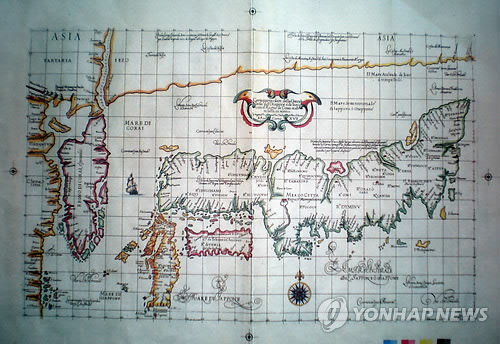


First of all,You can easily find " Mare di Corai" just east of Korea.
Second, it is bit difficult to check, but you can read two "Mare di Giapon", east and west of Kiusiu island.

Their explain finish here.

But...keep serching. Something written right side of double-head bird symbol, draw in the center of this map..

This Korean media photo is vague and difficult to detect what it is written.
So, check more clear image of very similar Dudley 1646 map stoared in Finland natinale library.

Click here to Finland national digital archive http://www.doria.fi/handle/10024/59106
Then choose P105-106 _kr201619_maps12.pdf (12.66MB) 
Quote;http://uni.2ch.net/test/read.cgi/newsplus/1334486803/175


Again, something is written right side of double-head bird symbol
。
”Il Mare Il Mare Sewenvorionale de lappone o Giappone”
(North Japan or habon Sea)


Yes, this map says Sea of Japan is "NORTH SEA OF JAPAN"
"Mare di Corai " is drawn at the just a east coast of Corean peninsula. It is not the position of Sea of Japan.

Yes, now you realise that stupid revisionist Korean Kim Munguil's typical method of historical distorture. He use vague map images and wrong map explanation to decieve Korean and world wide people with WICKED AMBITIOUS to justifies historical distorture for Korean national pride!


Ok, let me check other Dudley's 1646 map.
http://seaofjapan-noeastsea.blogspot.jp/2008/12/mer-du-co...

1646. ASIA CARTA DI CIASETE PIU MODERNA by R.Dudley

you can check the word of "Mer de corai" at the east coastal area of Chosun(Korean) peninsula and " Oceano Boriane Del Gappone" at Sea of Japan position.


That is to say, judging from those two Dudley's map , "Mare di Corai" means not the Sea of Japan today . It is just shows just a "East Coast of Korean peninsula".

I really don't understand why Korean scholor always abuses those stupid method of historical distorture and trimming. Shame on him.


I know everone here already underestand "the name of Sea of Japan" is NOT from the Japan's annexatin of Korea on 1910. the explorer La Perouse and Krusenstern who sailed around Sea of Japan and Korean coast, they draw two sea name, One is "Sea of Japan" and the other is "Strait of Korea" and makes it grobal standard around 1780-1830. La Perouse and Krusenstern established the definiation of Sea of Japan today, that is to say, Sea of Japan is the sea between
Tartary Str, La Perouse Str, Tsugar Str, Strait of Korea today.

On the other hand , Mer du Coree finally transformed to Brougton bay, and East Korean gulf today. Korea should rename East Korean Gulf to "East Sea" if they want. But,,,it is nonsense and arrogant claim they request name change of the Sea of Japan .

4/01/2012

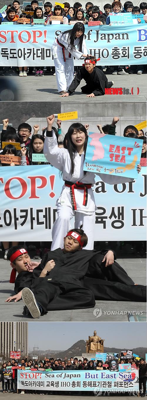
Brainwashed Korean student performance!

People who read my blog had already realise that the name of "Sea of Japan" become internatinal standard by the La perouse and Krusenstern's ages and Great Korean Imprerial (Daehan Imperial) also use the name of Sea of Japan before annexation of Korea.

Sadly, there still have a korean who can't accept the fact and believe Korean brainwashed Anti-Japan fabricated Propagandas incruding Takeshima illegal invasion and Sea of Japan naming dispute.

There are brainwashed extreme-natinalist Korean students protest against Sea of Japan.
They perform offensive protest against Japan with hatred.
I had just thought it is April fool joke....But it is real news lol.
http://news.naver.com/main/read.nhn?mode=LSD&mid=sec&sid1=102&oid=003&aid=0004419276

(Seoul-Newsis) report; Park Sunfung. 1st of April there are a protest against State of department and MOFA of UK which decide single-name description of "the Sea of Japan". at the Kuanfa-gate park.

【ソウル=ニューシス】パク・サンフン記者= 1日午前ソウル、光化門(クァンファムン)広場で独島(ドクト)アカデミー教育生が'SEA OF JAPAN'単独表記を支持した米国務省と英国外務省を糾弾するパフォーマンスを行って東海(日本海)を'EAST SEA'で表記することを促している。


O B E Y
NEVER TRUST HISTORICAL PRIMARY SOURCES ON YOUR EYES
BELIEVE THAT YOU ARE TOLD IN KOREAN SCHOOL
    BELIEVE THAT SHIN YEONNG-HA AND DR.YELLOW
  Brainwash IN KOREA
http://www.youtube.com/watch?v=aAK64INxLWk


2/17/2012

US to keep using term `Sea of Japan,` not `East Sea`

According to the Dong-a ilbo in South Korea on 17th Feb 2012, US replies to Korean lobbiest that US to keep using term `Sea of Japan,` not `East Sea`

It is quite fair decision US doesnt accept Korean fake propaganda of East sea -NOsea of Japan which Korean claims it derives from Japan's annexation of Korea 1910.

The blogger all here realize that Commandar Mattew Perry on boarding USS Sasquehana use the name of "Sea of Japan" on 1850's and Daehan Imperial (Korean Imperial) use the name of "Sea of Japan from late or 1880's , before annexation of Korea on 1910.
1856.(1855)Narrative of expedition of American squadron to Japan by Mattew.C.Perry Narrative of the expedition of an American Squadron
Korean use the name of "Sea of Japan" before annexation "

Dave Marsden was cheated by Koreans, but the Department of State isn't cheated by Korean fake propaganda.
Dave Marsden, You are CHEATED by KOREANS!


Quote; from Dong-A irbo http://english.donga.com/srv/service.php3?biid=2012021733968
US to keep using term `Sea of Japan,` not `East Sea`
a Korean-American group’s request for using the moniker “East Sea,” the official name used by Korea, the U.S. State Department responded that it will keep referring to the body of water separating Korea and Japan as “Sea of Japan.”

In a letter to the New York Korean-American Parents Association, which made the request, the State Department said that while it understood Korea’s use of the name "East Sea," Washington’s long-standing and consistent policy is to refer to the body of water as “Sea of Japan.”

Signed by U.S. Assistant Secretary of State for East Asian and Pacific Affairs Kurt Campbell, the letter said the U.S. hopes that Korea and Japan seek an agreement on the name of the sea through the International Hydrographic Organization.

The Korean-American association informed The Dong-A Ilbo of the letter Thursday. The letter was in response to the group’s request for a meeting with U.S. Secretary of State Hillary Clinton to petition Washington’s use of “East Sea” early this month.

http://english.donga.com/srv/service.php3?biid=2012021733968

2/12/2012

1870.Journeys in north China, Manchuria, and eastern Mongolia

Journeys in north China, Manchuria, and eastern Mongolia (1870)
Author: Alexander Williamson
Publisher:?

http://www.archive.org/details/journeysinnorth00willgoog

Attached map;
Sea of Japan:Sea of Japan.
Broughton bay:broughton bay
http://www.archive.org/stream/journeysinnorth00willgoog#page/n460/mode/2up

2/11/2012

1895.The Lands of the Rising Sun: A Talk with English Boys and Girls about China, Corea and Japan

The Lands of the Rising Sun: A Talk with English Boys and Girls about China, Corea and Japan (1895)
Author: William Theodore Aquila Barber
Publisher: C.H. Kelly
http://www.archive.org/details/landsrisingsuna00barbgoog

Attached Map
Sea of Japan: Sea of Japan
Strait of Korea:Corea Strait
Broughton Bay:Broughton Bay
http://www.archive.org/stream/landsrisingsuna00barbgoog#page/n38/mode/1up

2/10/2012

1863.Yedo and Peking. A narrative of a journey to the capitals of Japan and China

Yedo and Peking. A narrative of a journey to the capitals of Japan and China (1863)
Author: Fortune, Robert, 1813-1880
Publisher: London, J. Murray
Year: 1863
http://www.archive.org/details/yedoandpekingan02fortgoog

attached map:"The map of Japan and north China"
Sea of Japan: "Sea of Japan"
http://www.archive.org/stream/yedoandpekingan02fortgoog#page/n439/mode/1up
http://www.archive.org/stream/yedoandpekingan03fortgoog#page/n435/mode/1up


This site provides the full image of this map and confirms the name of Sea of Japan.
植物:和名および学名に関する話題

Sea of Japan: The Sea of Japan
Strait of Korea; Strait of Korea
Broughton Bay;Broughton Bay
East China Sea: Eastern Sea or Tunghai
http://www2.odn.ne.jp/had26900/wild_plant/wp_irumti/topics_on_pl_names.htm
http://www2.odn.ne.jp/had26900/wild_plant/wp_irumti/fareast_map1861.htm


Text: East China Sea : Tung-Hai or Eastern Sea,
http://www.archive.org/stream/yedoandpekingan02fortgoog#page/n344/mode/1up/search/japan+sea
On the morning of the 29th of July, 1861, the "Fiery Cross,' Captain Crockett, in which I was a passenger, got her steam up and stood out to sea. As we passed rapidly onwards towards the mouth of the bay, the towns of Yokuhama and Kanagawa, with the well^-known beadIslands in their vicinity, gradually to the green hills and lovely scenery of Japan. We had a pleasant passage down the North Pacific Ocean, through Van Dieman's Strait, and across the Tung-Hai or Eastern Sea, and arrived at Shanghae in China on a hot morning on the 4th of August.

2/09/2012

1788.A new system of modern geography

A new system of modern geography: or, A geographical, historical, and commercial grammar; and present state of the several kingdoms of the world .. (1788)
Author: Guthrie, William, 1708-1770; Ferguson, James, 1710-1776
Publisher: London : C. Dilly [etc.]
http://www.archive.org/details/newsystemofmoder00guth

text;the Sea of Japan.
http://www.archive.org/stream/newsystemofmoder00guth#page/600/mode/2up/search/japan
But the religion and government of the kingdom of Thibet,and Lassa, a large tract of Tartary, bordering upon China, are most remarkable and the most worthy of attention. The Thibetians are govened by the Grand Lama, or Dalai Lama, who is not only submitted to, and adored by them, but is also the great object of adoration for the various tribes or Heathern Tartars, who roam through the vast tract of continent which stretches from the banks of the Wolga, to Corea on the Sea of Japan.


A new system of modern geography : or, A geographical, historical, and commercial grammar ; and present state of the several nations of the world ... (1794)
Author: Guthrie, William, 1708-1770; Knox, John, 1720-1790
Volume: v.2
Subject: Geography
Publisher: Philadelphia : Mathew Carey
http://www.archive.org/details/newsystemofmoder02guth

http://www.archive.org/stream/newsystemofmoder02guth#page/58/mode/2up/search/Tartary
But the religion and government of the kingdom of Thibet,and Lassa, a large tract of Tartary, bordering upon China, are most remarkable and the most worthy of attention. The Thibetians are govened by the Grand Lama, or Dalai Lama, who is not only submitted to, and adored by them, but is also the great object of adoration for the various tribes or Heathern Tartars, who roam through the vast tract of continent which stretches from the banks of the Wolga, to Corea on the Sea of Japan.


A new system of modern geography, or, A geographical, historical and commercial grammar and present state of the several kingdoms of the world [microform] : containing, I. the figures, motions and distances ... : to which are added, I. a geographical index ... II. a table of the coins ... III. a chronological table ... (1795)
Author: Guthrie, William, 1708-1770; Ferguson, James, 1710-1776
Subject: Geography; Historical geography; Géographie; Géographie historique
Publisher: London : Printed for C. Dilly ... and G.G. and J. Robinson
http://www.archive.org/details/cihm_38822

http://www.archive.org/stream/cihm_38822#page/n731/mode/2up
But the religion and government of the kingdom of Thibet,and Lassa, a large tract of Tartary, bordering upon China, are most remarkable and the most worthy of attention. The Thibetians are govened by the Grand Lama, or Dalai Lama, who is not only submitted to, and adored by them, but is also the great object of adoration for the various tribes or Heathern Tartars, who roam through the vast tract of continent which stretches from the banks of the Wolga, to Corea on the Sea of Japan.


2/03/2012

1820.An Introduction to Ancient and Modern Geography

An Introduction to Ancient and Modern Geography: On the Plan of Goldsmith and Guy : Comprising ... (1820)
Author: Jacob Abbot Cummings
Publisher: Cummings and Hilliard
http://www.archive.org/details/anintroductiont05cummgoog

text: sea of Japan.
http://www.archive.org/stream/anintroductiont05cummgoog#page/n123/mode/2up/search/japan
Burrampooter, a few miles from Lassa. The foot of this mountain is inhabited by many thousand Lamas or priess, who according to their respective rank, are placed nearer or at a greater distance rom the sovereign pontiff. He is worshipped not only by the inhabitants of Thibet, but by various tribes of heathen Tartars who roam through the wast country that spreads from the Wolga to the sea of Japan.

1843.Guy's school geography on a new and easy plan

1843.Guy's school geography on a new and easy plan : comprising not only a complete general description but much topographical information, in a well digested order, exhibiting three distinct parts and yet forming one connected whole; expressly adapted to every age and capacity and to every class of learners, both in ladies' and gentlemen's schools (1843)
Author: Guy, Joseph
Publisher: London : Cradock; Whittaker
http://www.archive.org/details/cihm_48547

Attached Map:
Sea of Japan:Sea of Japan
East China Sea: Eastern Sea
http://www.archive.org/stream/cihm_48547#page/n109/mode/2up

betrayer :Untrustable United States Navy

United States Navy website delete the explanation of the name of Yellow Sea and the Sea of Japan with silence although on my past post(http://seaofjapan-noeastsea.blogspot.com/2010/08/20100718.html) I introduced that United States Navy website which explains West sea and East Sea is Yellow sea and Sea of Japan for Americans.

Past post on August 2010 :http://seaofjapan-noeastsea.blogspot.com/2010/08/20100718.html
“This is the first in a series of ROK-U.S. combined naval exercises that will occur in both the East and West Seas,” the two defense ministers said in their joint statement. To Americans, the East Sea is the Yellow Sea and the West Sea is the Sea of Japan.

the deleted text(I confiemed on 02/02/2012); http://www.defense.gov//News/NewsArticle.aspx?ID=60074
This is the first in a series of ROK-U.S. combined naval exercises that will occur in both the East and West Seas,” the two defense ministers said in their joint statement.

These kind of betray by the U.S Navy makes Japanese less and less frendly.

日本語版:
過去投稿 http://seaofjapan-noeastsea.blogspot.com/2010/08/20100718.htmlにおいて、
文中ではWest SeaとEast Seaを記載するも、To Americans, the East Sea is the Yellow Sea and the West Sea is the Sea of Japan.(アメリカ人にとってそれは黄海と日本海のことである、と注意書きを加えております。)と当時のサイトに説明があったのですが、2012/02/03に確認したところ、その文章が削除されていることがわかりました。つまり、West Sea/East Seaの単独表記にしているわけです。これだから米国は信用できません。

以下が過去の米国海軍のサイトの転写内容
http://seaofjapan-noeastsea.blogspot.com/2010/08/20100718.html
60074

“This is the first in a series of ROK-U.S. combined naval exercises that will occur in both the East and West Seas,” the two defense ministers said in their joint statement. To Americans, the East Sea is the Yellow Sea and the West Sea is the Sea of Japan.

そして、2012/02/03に確認された、削除後の内容

“This is the first in a series of [South Korean]-U.S. combined naval exercises that will occur in both the East and West Seas,” the two defense ministers said in their joint statement. 

この通り、今回
To Americans, the East Sea is the Yellow Sea and the West Sea is the Sea of Japan
.の部分がいつの間にか削除されていることが判明しました。

このような裏切りは、日本人のアメリカに対する親近感がますます薄くなっていくことになるでしょう。

2/02/2012

1881.Transactions of the Asiatic Society of Japan

Transactions of the Asiatic Society of Japan (1881)
Author: Asiatic Society of Japan
Publisher: The Society
Year: 1881

text:the Japan sea/
http://www.archive.org/stream/transactionsasi01japagoog#page/n69/mode/1up/search/sea
The greater snow-fall of west Japan is appearently due to the cold dry north and north-west winds which prevail during the winter months, picking up moisuture from the Japan sea and depositing it upon the first high Isnd, which will be the mountains of West and North Japan, with which it comes in contact.


http://www.archive.org/stream/transactionsasi01japagoog#page/n83/mode/1up
The Strait of La Perouse may have been formed in a manner similar to those of Tsugaru, and just as Yezo was cut off from the mainland, if marine denudation continues and Volcano Bay become much deeper, Northern Yezo may be cut off from Southern Yezo, and one more channel will be opened to connect the Japan sea with the Pacific Ocean.


検索作業途中備忘録:http://www.archive.org/search.php?query=Transactions%20of%20the%20Asiatic%20Society%20of%20Japan%20AND%20collection%3Aamericana

2/01/2012

1834.The Journal of the Royal Geographical Society, Volumes 41-50

The Journal of the Royal Geographical Society ..., Volumes 41-50
Author: Royal Geographical Society (Great Britain), Norton Shaw, Hume Greenfield, Henry Walter Bates
Publisher: J. Murray, 1834

http://www.archive.org/stream/journalroyalgeo33bategoog#page/n34/mode/2up/search/japan
Kuanetsof's expedition in Western Russia;Straitsky's to the Sea of Japan, Russian Manchuria, Sakhalin , &c

http://www.archive.org/stream/journalroyalgeo33bategoog#page/n224/mode/2up/search/japan
TYPHOONS in the Sea of Japan, xlii,142
Observations on, in the Japanese Sea, by Commander St, John, xli,p.elxii

1/31/2012

1897.Korea and Her Neighbours by Isabella Lucy Bird

Korea and Her Neighbors: A Narrative of Travel, with an Account of the Recent Vicissitudes and ... (1897)
Author: Isabella Lucy Bird
Publisher: Revell
Year: 1897
http://www.archive.org/details/koreaandherneig02birdgoog


Text: Sea of Japan
http://www.archive.org/stream/koreaandherneig02birdgoog#page/n100/mode/1up/search/japan

The Han itself, rising in the Diamond Mountain of Kong-won-Do, and formed by a number of nearly paralellaffuents, next to the border river Am-nok, is the river of Korea, which it cuts nearly across, its eastern extremity being within 25 miles of the Sea of Japan and its western at Chemulpo. I ascended it to within 40 miles of the Sea of Japan, and estimate the length of its navigable waters for small flat-bottomed craft at about 170 miles.

Attached map; unconfirmed (data defect)
http://www.archive.org/stream/koreaandherneig02birdgoog#page/n90/mode/1up

There are some descriptions of "east coast (of Korea)", although there are no "East Sea" and there are the name of Sea of Japan on the text.
http://www.archive.org/stream/koreaandherneig02birdgoog#page/n29/mode/1up/search/east
Owing to the configuration of the peninsula there are few good harbors, but those which exist are open all the winter. The finest are Fusan and Won-san, on Broughton Bay/ Chemulpo, which, as the port of Seoul, takes the first place, can hardly be called a harbor at all, the "outer harbor," where large vessels and ships of war Lie, being nothing better than a roadstead, and the "nner harbor," close to the wtown, in the fierce tideway of the esturary of the Han, is only available for fve or six vessels of small tonnage at time .The east coast is steep and rocky, the water is deep, and the tide rises and falls from 1 to 2 feet only. On the southwest and west coasts the tide rises and falls from 26 to 38 feet!


I can confirm "Sea of Japan" on attached map of Korea and her neighbor on 1898 eddition
Korea and her neighbors; a narrative of travel, with an account of the recent vicissitudes and present position of the country (1898)
Author: Bird, Isabella L. (Isabella Lucy), 1831-1904
Subject: Korea -- Description and travel
Publisher: New York, Chicago [etc.] F.H. Revell Co.
http://www.archive.org/details/koreaherneighbor00bird
Attached map;
Sea of japan: Sea of Japan
Broughton bay: Broughton bay
Strait of Korea: Strait of Korea
http://www.archive.org/stream/koreaherneighbor00bird#page/n20/mode/1up

1/25/2012

1856.(1855)Narrative of expedition of American squadron to Japan by Mattew.C.Perry

Narrative of the expedition of an American squadron to the China Seas and Japan : performed in the years 1852, 1853, and 1854, under the command of Commodore M.C. Perry, United States Navy, by order of the Government of the United States (1856)
Author: Perry, Matthew Calbraith, 1794-1858; Lilly, Lambert, 1798-1866; Jones, George, 1800-1870
Volume: v. 1
Subject: United States Naval Expedition to Japan, 1852-1854
Publisher: Washington : Beverley Tucker, printer
Year: 1856 (Attached map:1855)

Attached map;http://www.archive.org/stream/narrativeofexped0156perr#page/n346/mode/1up
Sea of Japan:J A P A N S E A
Strait of Korea:KOREA CHANNEL
broughton bay; Gulf of Corea


The photos below are the another images of Chart by Commandar Mattew Perry , another blogger's post. Ofcourse they use the name of "Sea Of Japan"

http://blog.daum.net/sabul358/14309068


http://sea.ap.teacup.com/seiasouan/6.html
井蛙草庵(せいあ そうあん) 第一巻 2006/6/1 「第5話 古地図(3) 日本列島」  古地図


http://saltyfriendstsushin.seesaa.net/article/109374494.html
Salty Freinds通通信:2008年11月10日 ■□ 船長の見たペリー艦隊 ☆最終回☆ By大河原明徳さん □■


P.S Dear Dave Merdison, you claimed "the name of Sea of Japan distorted during annexation of Korea on 1910"? I guess LIER Korean association cheats you with fake Korean govemental anti-Japan propagaganda. You must realize their propaganda is fake, by the Mattew Perry Map and Korean Imperial's textbooks and official documents before 1910. shame on you.

Korean scholor Sangbok D. Hahn(韓相復)'s blog explained the name of Sea of Japan had already established as a international mane when China pilot (1861)was published.

동해의 국제적 명칭은 Sea of Japan으로 이미 이 때 굳어졌으며, 그 근원은 La Perouse의 과학적 탐사결과 입니다. 이제 우리가 할 일은 동해를 접하고 있는 연안국 모두가 부르기 좋은 이름으로 고치는 협의 입니다. China Pilot는 중국수로지(中國水路誌)라고 번역할 수 있으며, 동북이시아 해역의 항해안전을 위한 안 http://seaofjapan-noeastsea.blogspot.com/2009/07/1861china-pilot-third-edidtionking-john.html
Sea of Japan ,the international name for Donghae(East Sea) had already estabished, that is originate from the survey and study by La Perouse (on 1790's).

It means, he admit the name of Sea of Japan is NOT Japan's imperiarism under the annexation of Korea.


Dear Virginia citizens, Please not vote for Sen.Dave Mardison the nuts. He was easily cheated by Korean fake govemental anti-Japan propaganda and I dont think he can decide right political decision who supports SB200 are just judges from Korean wrong propaganda paper.

1/24/2012

Dave Marsden, You are CHEATED by KOREANS!

According to the Korean media, Mersdin explained that there are the naming confusion about Sea of Japan after during the annexation of Korea (*1910)

But, those Marsdin's explanation is totally wrong. It is the around 1780-1830 the name of Sea of Japan estblished as a global standard, ofcourse it is before annexation of Korea. I guess Dave Marsden are cheated by Korean lier-fascist nationalist. Dave Mardin's epic fail!リンク
Korean claims that the name of Sea of Japan by the japan's imperiarism, is totally wrong claim.

Korean Imperial (Daehan Imperial) use the name of Sea of Japan before annexation of Korea on 1910. There are a Korean textbook published on 1897 and 1899 which writes sea of Japan.
https://sites.google.com/site/japanseamerdujapon/Home/korean-use-the-name-of-sea-of-japan-i

Ofcourse, in the United States they use the name of Sea of Japan at least 1850's when commandar Mattew Perry on boarding USS Sasquehana and arrival Japan, he use the name of Sea of Japan in his chart.
http://seaofjapan-noeastsea.blogspot.com/2011/12/dear-mark-kirkkorean-lies-about-sea-of.html

The name of Sea of Japan was established by the effort of the survey by La Perouse and Krusenstern around the Sea of Japan during 1790-1830 ages. The blanc waters of the chart solved by their survey and "the Sea of Japan" and "Strait of Corea" become internatinal standard name. UK and France sailing guide around east asia they all write the name of "Sea of Japan" around 1830-1850's.
https://sites.google.com/site/japanseamerdujapon/Home/hidrographic-magazine-and-admirary-chat-and-sea-of-japan-strait-of-corea-and-brougthon-bay

Dave Mersden's SB200 are stupid.

1/22/2012

Korean historical distorture movement on library

The Youtube video brainwashed nationalist Korean appeal and promote the movement to put the "East Sea" patch onto atlas having a original descrpition of "Sea of Japan". Original description of document ,maps and primary source should not be distort.


以下の動画は、韓国人が図書館においてある”日本海”を記した地図に、”East Sea"のシールを貼り付けよう、という動画です。 一次資史料や地図の改竄はとんでもない暴挙です。


The movie above seems to be the library in South Korea. Korean media reported that Korean association in Chicago will do a movmement "delete Sea of Japan" at the Library of U.N Hammarskjöld, main universities and so on.

この動画は韓国国内の図書館であると考えられますが、韓国側報道によると、日本海削除運動をを米国内のほかの図書館でも行う計画があると報道されています。
また、シカゴ韓人会は、アメリカ議会図書館、UNハマーショルド図書館、 アメリカの主要大学の図書館や出版社が所蔵する文献で竹島と日本海表記を 独島と東海と正す、独島守護国際連帯の事業に積極的に協力する計画だ。
聯合ニュース(韓国語) 2011/12/10
http://www.yonhapnews.co.kr/bulletin/2011/12/10/0200000000AKR20111210040200009.HTML
http://awabi.2ch.net/test/read.cgi/news4plus/1323665924


Those insane movement comes from their Anti-Japan brainwashed propaganda education when they were in kindergarden . Then they do the justification of illegal occupation of Takeshima(Liancourt Rocks) and rewrite chats of Sea of Japan with wrong grounds claimed by Korean govt".
韓国人のこういった狂った運動は、幼児期からの強い反日教育プロパガンダが病巣となっています。これらによって韓国人は反日を刷り込まれるようになります。そして地図歪曲動画や竹島侵略を正当化し始めます。


Korean's anti-Japan brainwash propaganda at the school list.

Ofcourse, reader of my blogger knows Sea of Japan is right term and nothing to do with Japan's annexation of korea or imperiarism. It is international standard/conventional term comes from La Peoruse or Krusenstern's effort to survey around the Sea of Japan and Korean Imperial use the name of Sea of Japan alredy in 1899 before Russo-Japan war 1904 and annexation of Korea 1910 without "forced by Japan imperial".
・Age of Voyage of Discovery around Sea of Japan 1780-1830
・Pilot ,Hidrographic magazine ,and Admiraly Chart 、Geography gazette and Sea of Japan, Strait of Corea, and Brougthon bay.
・Korean use the name of "Sea of Japan" before annexation "

もちろん、私のブログの読者の皆様は、日本海という名称は国際名称としては正しいものであり、韓国併合とは関係なく成立した名前であることはご理解いただけたと思いますが、日本海の名称はこの日本海や韃靼周辺の海域を調査したラペローズやクルーゼンシュテルンの努力によるもので1929年のIHO総会以前に既に国際慣習名でしたし、大韓帝国も「日本海」を日韓議定書や日露戦争以前に普通に使っていました。