REPORTS ON THE WORK OF THE IHO FOR THE PERIOD 2007 - 2011
http://www.iho.int/mtg_docs/conf/18IHC2012/docs/CONF18_WP1_Add.1.pdf
Addendum 1 to WORK PROGRAMME No. 1 CORPORATE AFFAIRS
REPORT ON WORK TO REVISE IHO PUBLICATION S-23
Report on work to revise IHO Publication S-23 – “Limits of Oceans and Seas”
PDF P4
A. DESCRIPTION OF ACTIVITY UP TO THE XVIIth IHC IN 2007 PDF P2 (omit)
B. DESCRIPTION OF ACTIVITY FROM XVIIth IHC IN 2007 TO THE XVIIIth IN 2012 PDF P2 (omit)
C. WAY FORWARD PDF P4
9. The work of the S-23 WG and the positions expressed by various members of the WG have been affected significantly by diplomatic lobbying of the interested States. The highly political nature of the issue is, to a large degree, overwhelming the technical purpose of the publication and of the Organization. Based on the history of efforts over the last 20 years to find a way forward in naming this sea area, it has to be recognized that a new edition of the publication S-23 can not be progressed until an agreement between the interested States is reached. This position has been reflected most recently in the responses expressed by various Member States to CL 24/2012.
10. In the circumstances, noting the lack of any significant progress made over such a considerable number of years and considering that the proposals of the S-23 WG have not been accepted by Member States as indicated in CL 38/2012 the question that now has to be asked is whether Member States still wish to pursue the development of an up-to-date edition of S-23.
If the answer to this question is YES, then Member States must be prepared to indicate how this can now be achieved.
If the answer is NO, then Member States must decide
whether the current but out of date 3rd edition of S-23, which has not been revised for nearly 60 years, will continue to be an active, but ineffective, IHO reference publication
or
whether the publication should be discontinued.
In deciding the way forward, Member States should also consider the adverse effect on the reputation and the credibility of the Organization and its publications if it is unable to resolve this matter after so long.
Referemce:CL24/2012 2012/02/20
http://www.iho.int/mtg_docs/circular_letters/english/2012/Cl24e.pdf
reference:CL38/2012 2012/03/30
http://www.iho.int/mtg_docs/circular_letters/english/2012/Cl38e.pdf
PDF P8
Item 4. As there has been no consensus between the members of the S‐23 WG on the issue of naming the sea area between the Korean peninsula and the Japanese archipelago, what are your views on possible ways
forward for progressing a new edition of S‐23?
• Thirty‐one (31) Member States provided comments to the question of possible ways forward for progressing a new edition of S‐23. Eleven (11) Member States did not comment. Twenty‐two (22) Member States indicated that the concerned States must continue their efforts to find a common accepted way to name the sea area in question, some of them indicating views on how the issue could be handled. It may be noted that three (3) Member States indicated that the updating of S‐23 should be considered on a regional level or chapter by chapter;
4/26/2012
I.H.O 「日本海単独表記」S-23改訂版は今回は失敗・議論延期?
日本側報道で、「日本海単独表記が決定」と報道しているようですが、決定されたと言うのは適切ではなく、1953年に発行された「日本海単独表記」の海図の改定の延期もとそれにともなう現状維持にすぎないと言う話です。
第4版改定S-23の発行は、日本海単独表記か、東海併記かを含めて2017年に持ち越しもしくは今後の予定未定と言う話だと考えられます。
日本の提案ですが、報道によると、既に合意が形成されている部分に関してはそれを修正した上で新版を発行し、合意が未形成の部分(たとえば日本海)に関しては、第三版の内容(日本海単独表記)を記載して発行し、WGで引き続き議論を行なっていくというものです。
しかし、この日本の提案は否決されました。
これにより、今後S-23の改定がどうなるのか、よくわからない状態になっています。外務省発表では、「新たな決定を行なわない」との話ですが、それでは今後のS-23の改定作業に関する話がどうなったのか?よくわかりません。
IHOサイトのS-23WGのページにおいて、時期ミーティングはTo be decidedと有るだけです。ただし、S-23WGが解散という話もありません。
http://www.iho.int/srv1/index.php?option=com_content&view=article&id=446&Itemid=402
どの国が賛成し、どの国が反対・棄権したか、外務省は日本の提案に協力していない国家名を逐一報告し、どの国が日本に協力的で、どの国がそうでないか、懸案ごとに国民に公表し、リスト化すべきです。
以下、現時点の報道から推測される状況
・IHO加盟国は、日本の提案によるS-23の新版への更新を承認しなかった。
(米国や英国も含む)。日本の提案とは、合意が形成されているところは、その内容を更新しし、合意が形成されていない内容は、従来の第三版の合意内容(日本海の件については日本海単独表記)を掲載して出しながらも、WGで継続して作業を進めていく」すと言うもの。
米国と英国は事前に単独表記を支持しておきながらも、日韓両国の合意が形成されることが望ましいと事前に表明していたと報道がありましたが、この発言は 日本を擁護しているように見える一方で、実はまったくそうではなく、日韓のトラブルに巻き込まれるのを避ける中立的な発言。このことから今回のIHOでの 日本の提案に賛成しなかったと考えられる。つまり米国は実質上日本を裏切っているわけです。今回、日本の提案に賛成した国は日本以外に皆無。
・韓国は「東海を併記する」よう議決を提案していない。つまり、東海を併記するかという議決自体が行なわれていなかったわけであり、東海併記をIHO加盟国が拒否したとは言えない。ここが曲者
・IHOのS-23WG各国の殆どが日本提案の投票は棄権。これは ”52 Japan Sea" については、関係国(日本と韓国(+北朝鮮))で協議して解決して合意されるべき、という言うもの。
これは総会に先立ってIHOからWG加盟国に対するCL 38/2012による問い合わせの各国の回答でこのような意見が目立った。
・日本の提案に反対したのは中国韓国北朝鮮キューバ。
・S-23の改訂作業とそのためのWGについては計画未定。
「合意形成」等で新版更新と発行を目指すか、S-23自体の更新・発行作業は時代遅れなのでもうやめるか(IHOの定義による国際標準名というコンセプト自体の廃止)、と言う議論も含めて全く行動計画が未定
・加盟国には、既にS-23は海図の統一のためと言う本来の目的ではなく、外交問題になっている節があり、電子海図等が発達している現在、無理に存続させていくのか疑問という意見。
・そのため、S-23については、更新しないまま現状のものを存在させる(つまりS-23の第三版は廃棄も無効ともせずにとりあえず一応存続させている
という流れです。
日本のメディアとかTwitter(おそらくTwitter民≒2chの話)では勝利宣言的な内容が圧倒的に目立ちますが、
たしかに、韓国の主張する「東海」併記は今回は行なわれなかったわけですので、韓国側から見たら、「失敗」ですが、
一方で、「日本海単独表記」による新版への更新は国際社会は認めなかったわけです。
それ故、「日本海単独表記」が改めて世界に認められた、とは言えない状況であり、実質的な日本外交の敗北でもあると私は判断しています
以下、関連報道のまとめ
平成24年4月26日 外務省
http://www.mofa.go.jp/mofaj/kinkyu/2/20120426_231904.html
国際水路機関(IHO)総会をめぐる議論について
1.4月23日(月曜日)から27日(金曜日)の日程でモナコにおいて国際水路会議(国際水路機関(IHO)総会)が行われ,日本海呼称問題についても議論が行われました。
2.その結果,26日(木曜日)に,世界の海域の境界と名称を記載したIHO出版物(「大洋と海の境界」(S-23))の現行版(1953年版)について 新たな決定を行わないことが確定しました。この結果,IHOとしてこれまでどおり,日本海単独表記を継続維持することとなりました。
3.今次総会においては,我が国より日本海は国際的に確立された唯一の名称であり,これを変える必要性も根拠もない旨発言するとともに,責任あるIHO加盟国として,建設的に貢献する用意がある旨表明しました。
4.我が国としては,日本海は国際的に確立した唯一の呼称であるとの確固たる原則の下で,今後ともIHOの関連作業に建設的に関与していく考えです。
2012.04.26 22:15
http://www.47news.jp/CN/201204/CN2012042601002003.html
「日本海」の呼称、他は認めず 国際水路機関決める
【モンテカルロ共同】世界の海図や海、海峡の名称などを調整する国際水路機関(IHO)は26日、モナコのモンテカルロでの総会で、韓国が「日本海」の呼称を「東海」と併記するよう求めている問題を討議、「日本海」単独呼称のままとすることを決めた。
韓国代表団はこの決定を「結論先送り」と受け止めており、今後も国際機関の会合の場などで併記実現を働き掛けていく方針。
IHOの刊行物「大洋と海の境界」は1953年発行以降、現在の第3版まで「日本海」単独の表記が続いてきた。総会は改訂作業の進め方については結論を出しておらず、今後も問題が再燃する可能性はある。
2012.04.26 20:30
http://news.searchina.ne.jp/disp.cgi?y=2012&d=0426&f=national_0426_178.shtml
韓国の外交通商部当局者によると、議長は今回の総会では何も決定しないと宣言したという。 【韓国メディア】は、結論は2017年の次回総会に持ち越しになったと報道。
2012.04.26 19:41
http://headlines.yahoo.co.jp/hl?a=20120426-00000140-jij-int
【ソウル時事】「東海」併記は見送り=「日本海」単独表記を維持―海図集の改訂をめぐり...........議論がまとまらず、2017年の次回総会に持ち越しとなった。「日本海」単独表記の現行版が維持される。【韓国の聯合ニュース】が26日伝えた。 (→S23の第4次改訂版は今回出ず、次回に持ち越しと報道)
2012.4.26 19:19
http://sankei.jp.msn.com/world/news/120426/erp12042619210004-n1.htm
韓国が「日本海」の呼称を「東海」と併記するよう求めている問題を討議、「日本海」単独呼称のままとすることを決めた。【共同】(→S-23の第4次改訂版に単独表記と出るのかでないのかが不明)
2012.04.26 19:08
http://www.koreaherald.com/national/Detail.jsp?newsMLId=20120426001355
The International Hydrographic Organization on Thursday delayed its decision on Seoul’s request that the name “East Sea” be used together with “Sea of Japan” for the body of water between the two countries.
The issue will be dealt with in the next meeting of the intergovernmental organization representing maritime bureaucrats around the world in 2017, Seoul officials said.
(From news reports)
2012/04/26 18:36 (Monaco 10:36)
http://www.47news.jp/news/flashnews/
「日本海」は単独呼称維持 国際水路機関は総会で、日本海の単独呼称の維持を決定。韓国は東海との併記を求めている。 2012/04/26 18:36 【共同通信】
(→*S-23の第4次改訂版に単独表記と出るのかでないのかが不明)
2012/04/26 18:07
http://japanese.joins.com/article/164/151164.html?servcode=A00§code=A10
国際水路機関(IHO)が「東海併記」の国際標準採択について結論を出せず、結局、5年後の2017年に持ち越されることになった。.........「大洋と海の境界」(第3版)の改訂版も延期される見込みだ。
2012-04-26 17:46
http://news.naver.com/main/ranking/read.nhn?mid=etc&sid1=111&rankingType=popular_day&oid=032&aid=0002213266&date=20120426&type=0&rankingSeq=1&rankingSectionId=100
日本代表団は先立って25日<海洋と海の警戒(境界)>の最近版(1953年)の3版を基準として修正に合意した部分だけ直して、残りは3版そのまま内資は案を出したが否決された。 日本側が出した抱いた3版に表記された‘日本海’は新しい合意がないから3版そのまま維持しようとの趣旨であった。 この案に日本だけ賛成票を投げて、残り国家は反対または、棄権したと伝えられた。
................白紙国際機構局長が導いた韓国代表団はあえて東海(日本海)と日本海を併記する中(案)を表決に送ることはなかった。 日本側が会員国らを相手に作業をしておいたので表決に送っても否決される可能性が非常に高いと見たためだ。
政府は今回の総会を控えて東海(日本海)を併記するために最善を尽くして外交折衝戦を展開すると明らかにしたことがある。
一方IHO総会期間途中韓国、北朝鮮代表団はときおり会って情報を交換して共同歩調を取る姿を見せて目を引いた。 北朝鮮代表団(団長キム・ウンチョル北朝鮮水路局副局長)は今回の会議で‘朝鮮東海(日本海)(East Sea of Korea)’で表記しなければなければならないと主張して日本海単独表記を強力に非難した。 人民軍最高司令部特別作戦行動塑造の対南挑発予告で韓半島の緊張が最高潮に上がった中で韓国、北朝鮮は東海(日本海)表記問題では共同戦線を形成したわけだ。
2012-04-26 14:06
http://news.nate.com/view/20120426n15571?mid=n0200
http://www.kjclub.com/jp/exchange/theme/read.php?tname=exc_board_65&uid=60948&fid=60948&thread=1000000&idx=1&page=1&number=42298
今回は最低目標である"日本海単独表記"を防ぐも、2017年、次期総会の結果は予測できない可能性が大きくなった。....................
1953年改定された3版"日本海単独表記"を維持する"ペテン"だ。合意されていない事項は、現行版を維持するという趣旨であるからである。このため、提案の議論かどうかを決定する投票でも日本だけ承認した。南北と中国·キューバが反対し、残りのほとんどが棄権しての提案は自動的に廃棄された。
2012/04/26 10:11 Korea times
HO rejects Japan's proposal to rule out East Sea name
http://www.koreatimes.co.kr/www/news/nation/2012/04/117_109729.html
Japan suggested partly revising the global chart without touching on contentious issues, in an apparent bid for the status quo, but only Tokyo voted for the proposal, Seoul officials said.
2012/04/26 08:34
http://www.chosunonline.com/site/data/html_dir/2012/04/26/2012042600530_2.html
東海呼称問題:4日間の議論で結論出ず、併記は留保か
2012/04/26 09:55
http://news.searchina.ne.jp/disp.cgi?y=2012&d=0426&f=national_0426_056.shtml
日本海」の単独表記案、賛成は日本の1票のみで否決=韓国
IHOは、現地時間の26日午前、東海の表記に関する議論を再開する。
日韓間のし烈な外交戦の中で4日目を迎える総会は、今日にも最終的に決定する見通し
Korean claim; Defect on the Chart S-23?
The previous text "Japan Sea(52)" on S-23
52 Japan Sea
On the Southwest
The Northeastern limit of the Eastern China Sea (50) and the Western Limit of the Inland Sea (53).
Kim-Shin claimed it is invalid of the S-23 Japan Sea text ,lack of limit definiation of southwestern limit of the Japan Sea(Japanese.yonhapnews 25thApr2012) But it must not be a ground that the name of Sea of Japan is invalid and ground to add "East Sea". It is just a very easy solution of the text to fix a text below example. The boundary between Eastern China Sea and Sea of Japan is already defined. In addition, the definiation of the Yellow Sea(51) southeast boundary is already explained in S-23.
52 Japan Sea
On the Southwest
The Northeastern limit of the Eastern China Sea (50) and the Western Limit of the Inland Sea (53)and "Southeastern limit of Yellow Sea (51)

より大きな地図で S-23 Japan Sea, Yellow Sea and East China Sea を表示
(日本人向けに簡単に説明:確かに52日本海の南西端の説明があいまいなことは確かである。一方、50東海(東シナ海)の北端と、53黄海の南東端は既に定義が出来ている。このことから50日本海の説明に、”53黄海の南東端”を付け加えればよいだけ)
References; S-23
http://www.iho-ohi.net/iho_pubs/standard/S-23/S23_1953.pdf
52.-Japan Sea
On the Southwest
The Northeastern limit of the Eastern China Sea (50) and the Western Limit of the Inland Sea (53).
On the Southeast
In Simonoseki Kaikyo.
A line running from Nagoya Saki (130"49'.05E) in Kyusyu through the island of Uma Sima and Muture Sima (33"58'05 N) to Murasaki Hana (34"01' N) in Honsyu.
50-East China Sea (Tung Hai)
On the east.
From Haderuma Sima a line including the Miyako Retto to the east point of Miyako Sima and thence to Okinan Kaku, the southern extremity of Okinawa Sima[註 4] through this island to Ada-Ko Sima (Sidmouth Island) on to the East point of Kikai Sima (28°20'N) through Tanegra Sima (30°30'N) to the north point thereof and on to Hi-Saki (31'17'N) in Kyūshū.
On the north.
From Nomo Saki (32°35'N) in Kyusyu to the south point of Hukae Sima (Goto Retto) and on through this island to Ose Saki (Cape Goto)[註 5] and to Hunan Kan, the South point of Saisyu To (Quelpart), through this island to its western extreme and thence along the parallel of 33°17' north to the mainland.
51-Yellow Sea
On the South.
The parallel of 33度17分 North from Saisyu To (Quelpart) to the mainland.
On the Southeast.
From the Western extreme of Quelpart to Ka Nyo or West Pinnacle Island( 34.13N) in the Mengoru Group, thence to the North point of Oku To (34.22.N), to the West point of Small South Stone Island (Syo Zyonan To) and the North point of Great South Stone Island (Zyonan To) (34.24'N) to the point of the coast of Tin To (34.25'N) along the Northwest coast of this island to the North Point thereof , and thence of a line in a Northeasterly direction to the mainland of Tyosen (Korea)
53-Inland Sea of Seto Naikai
On the West
The Southeastern limit of the Japan Sea (52)
52 Japan Sea
On the Southwest
The Northeastern limit of the Eastern China Sea (50) and the Western Limit of the Inland Sea (53).
Kim-Shin claimed it is invalid of the S-23 Japan Sea text ,lack of limit definiation of southwestern limit of the Japan Sea(Japanese.yonhapnews 25thApr2012) But it must not be a ground that the name of Sea of Japan is invalid and ground to add "East Sea". It is just a very easy solution of the text to fix a text below example. The boundary between Eastern China Sea and Sea of Japan is already defined. In addition, the definiation of the Yellow Sea(51) southeast boundary is already explained in S-23.
52 Japan Sea
On the Southwest
The Northeastern limit of the Eastern China Sea (50) and the Western Limit of the Inland Sea (53)and "Southeastern limit of Yellow Sea (51)

より大きな地図で S-23 Japan Sea, Yellow Sea and East China Sea を表示
(日本人向けに簡単に説明:確かに52日本海の南西端の説明があいまいなことは確かである。一方、50東海(東シナ海)の北端と、53黄海の南東端は既に定義が出来ている。このことから50日本海の説明に、”53黄海の南東端”を付け加えればよいだけ)
References; S-23
http://www.iho-ohi.net/iho_pubs/standard/S-23/S23_1953.pdf
52.-Japan Sea
On the Southwest
The Northeastern limit of the Eastern China Sea (50) and the Western Limit of the Inland Sea (53).
On the Southeast
In Simonoseki Kaikyo.
A line running from Nagoya Saki (130"49'.05E) in Kyusyu through the island of Uma Sima and Muture Sima (33"58'05 N) to Murasaki Hana (34"01' N) in Honsyu.
50-East China Sea (Tung Hai)
On the east.
From Haderuma Sima a line including the Miyako Retto to the east point of Miyako Sima and thence to Okinan Kaku, the southern extremity of Okinawa Sima[註 4] through this island to Ada-Ko Sima (Sidmouth Island) on to the East point of Kikai Sima (28°20'N) through Tanegra Sima (30°30'N) to the north point thereof and on to Hi-Saki (31'17'N) in Kyūshū.
On the north.
From Nomo Saki (32°35'N) in Kyusyu to the south point of Hukae Sima (Goto Retto) and on through this island to Ose Saki (Cape Goto)[註 5] and to Hunan Kan, the South point of Saisyu To (Quelpart), through this island to its western extreme and thence along the parallel of 33°17' north to the mainland.
51-Yellow Sea
On the South.
The parallel of 33度17分 North from Saisyu To (Quelpart) to the mainland.
On the Southeast.
From the Western extreme of Quelpart to Ka Nyo or West Pinnacle Island( 34.13N) in the Mengoru Group, thence to the North point of Oku To (34.22.N), to the West point of Small South Stone Island (Syo Zyonan To) and the North point of Great South Stone Island (Zyonan To) (34.24'N) to the point of the coast of Tin To (34.25'N) along the Northwest coast of this island to the North Point thereof , and thence of a line in a Northeasterly direction to the mainland of Tyosen (Korea)
53-Inland Sea of Seto Naikai
On the West
The Southeastern limit of the Japan Sea (52)
4/21/2012
1827.A geographical, historical, and commercial grammar exhibiting the present state of the world
1827.A geographical, historical, and commercial grammar exhibiting the present state of the world [microform] : and containing, I. The figures, motions, and distances of the planets ... XI. The chief cities, structures, ruins, and artificial curiosities : to which are added, I. A geographical index, with the names of places alphabetically arranged ... eminent and illustrious persons of every age and nation (1827)
Author: Guthrie, William, 1708-1770; Ferguson, James, 1710-1776
Publisher: [London? : s.n.]
attached map (world map ):
Sea of Japan;Sea of Japan
East China Sea; Eastern Sea
http://www.archive.org/stream/cihm_18885#page/n9/mode/2up

text:Sea of Japan
http://www.archive.org/stream/cihm_18885#page/n767/mode/2up/search/japan
Tibet.......... be in the hands of the lamas, or pontiffs, of whom the cheif, caled the Dalai Lama, is not only submitted to and adored by the Tibetans, but is also the great objet of veneration among the various tribes of Tartars who roam through the vast tract of continent which stretchs from the banks of the Wolga, to Corea on the Sea of Japan.
Draft of I.H.O resume 2007-2011
”Draft"
In AuXVIIIth INTERNATIONAL HYDROGRAPHIC CONFERENCE MONACO, 23 - 27 April 2012gust 2002 a final draft of the 4th edition was again submitted to Member States for approval(refer to CL N°30/2002 dated 9 August 2002)
REPORTS ON THE WORK OF THE IHO FOR THE PERIOD 2007 - 2011
http://www.iho.int/mtg_docs/conf/18IHC2012/docs/CONF18_WP1_Add.1.pdf
4/18/2012
1879.亜細亜地誌
亜細亜地誌(百科全書);Geography of Asia (encyclopedia)
Author Yotsuya Junzaburo: [東京] 文部省 1879(明治12)
Attached map; (Sea of Japan) 日本海
http://opac.lib.hiroshima-u.ac.jp/image/20823/20823003.jpg

Text:日本海(Sea of Japan)
水勢 (Oceans)
http://opac.lib.hiroshima-u.ac.jp/image/20823/20823008.jpg
1872.萬国地理啓蒙
1872.萬国地理啓蒙
by Goldsmith( 哥徳斯米) Trabskate;Mochizuki Makoto 望月誠訳
出版・頒布等 東京 甘泉堂 1872(明治5)
Attached map; Sea of Japan (日本海)
http://opac.lib.hiroshima-u.ac.jp/image/10482/10482028.jpg

by Goldsmith( 哥徳斯米) Trabskate;Mochizuki Makoto 望月誠訳
出版・頒布等 東京 甘泉堂 1872(明治5)
Attached map; Sea of Japan (日本海)
http://opac.lib.hiroshima-u.ac.jp/image/10482/10482028.jpg
4/16/2012
Korean revisionist White House "petition" filled up with distorture
The text below are korean claim on White House "East Sea" petition. I point out how their claim is filled up with distorture by the Korean revisionist and fascist. I dare say people who join this petition must be Korean revisionist.
Sources from Yonhapnews.(ROK) http://english.yonhapnews.co.kr/news/2012/04/06/26/0200000000AEN20120406000200315F.HTML
1. As a result of gruesome military expansionism, Japan changed "East Sea" (the original name of sea bordered by Korea, Russia, and Japan) to "Sea of Japan" in 1928
・True history: There are no EAST SEA on the chart before 1928. all of Pilot/Hydrographic magazine ,and Admiraly Chart 、Geography gazette use Sea of Japan and Strait of Corea.
The Korean claim "1" is fake propaganda.The Name of East Sea had never been in any world maps. Some maps describes "Sea of Korea", mostly before La Perouse's Sea of Japan navigation.but it had become rapidly minority from the world map after the La Perouse and Krusenstern's inspection on the Sea of Japan ,during 1780's to 1810's. Finally on 1840's minority "Sea of Korea" completely extinct. See Japanese goverment map reserch. http://www.mofa.go.jp/policy/maritime/japan/index.html#5)
2. Korea was liberated in 1945, but Japan still refuses to return "East Sea" to its original identity.
3. Our veterans were the major force defeating Japan in World War II. We helped Korea to regain its freedom.
・True history:Korean use the name of "Sea of Japan" before annexation "
Before annexation of Korea by Japan on 1910, Global community includes United States use the name of Sea of Japan. In addition, Korean imperial already use the name of "Sea of Japan" as the global name. So, their issue "2" and "3" is nothing gound to rename Sea of Japan.
4 .However, we are still teaching our children a FALSE history that was manipulated by the invader who attacked "Pearl Harbor".
・True history:United States already use the name of Sea of Japan :1856.(1855)Narrative of expedition of American squadron to Japan by Mattew.C.Perry
United States already use the name of Sea of Japan till at least around 1850's ,before annexation of Korea(1910). they had never use the name of "East Sea". Those fact proves it is right name of " "Sea of Japan"
Please join us and sign this petition to correct a FALSE history in our textbooks. Our children have right to learn a TRUE history!
・Why Korean claims "East Sea"? It is because of Unwholesome nationalism
Those Korean education video which makes children spolied anti-Japanese propaganda.American teach false history??? Joke. Check Commandar Mattew Perry map aboarding USS Sasquehana, U.S navy also use the name of "Japan Sea" on 1850's. So, Korean claim "4" is FALSE propaganda which is not a HISTORY. In addition, Korean purpose to rename with revisionist theory is to justifies the illegal invasion of Takeshima island (Liancourt Rocks) on the Sea of Japan which are not signed in the Peace treaty with Japan as the isaland which Japan renounces"
Joining Korean false propaganda with anti-Japan movment makes it justifies you are Korean fascist and revisionist! See those video you can realize how they are brainwasied by Korean goveremental propaganda!.
references:http://gogakudojo.com/article9/index.html
日本語版:
韓国側の主張1: As a result of gruesome military expansionism, Japan changed "East Sea" (the original name of sea bordered by Korea, Russia, and Japan) to "Sea of Japan" in 1928
本当は:1928年の時点でも「East Sea」という表記は海図に存在しない。すべての水路誌や地名辞典は1850年代には既に日本海と朝鮮海峡を記述している。
・True history: all of Pilot/Hydrographic magazine ,and Admiraly Chart 、Geography gazette use Sea of Japan and Strait of Corea.
韓国側の主張”1!は事実を歪曲している反日プロパガンダです。 西洋の地図には「East Sea」という表記は最近まで記載されたことはありません。一時期、「Sea of Korea」と表記された地図は、あります。それは主にD'anvilleのRoyaume de Coree以降、ラペローズの日本海探検発表前の期間です。しかしながら、ラ・ペルーズやクルーゼンシュテルンの日本海探検によって、この「Sea of Korea」という表記が急減少、極僅かになり、最終的には1840年代に完全消滅します。
これについては日本外務省の古地図調査資料をご覧ください。 http://www.mofa.go.jp/policy/maritime/japan/index.html#5)
韓国側の主張 2.3
2. Korea was liberated in 1945, but Japan still refuses to return "East Sea" to its original identity.
3. Our veterans were the major force defeating Japan in World War II. We helped Korea to regain its freedom.
本当は:大韓帝国時代も、韓国は既に「日本海」を使用していた。これは1910年の日韓併合や、1905年の日露戦争以前のお話です。
・True history:Korean use the name of "Sea of Japan" before annexation "
韓国は、近代化教育を始める準備としてまず学部編纂局が教科書を作成しますが、それらは当時既に国際慣習名称として定着していた「日本海」を書いています。つまり、第二次大戦云々は余り関係がありません。韓国が、日本海呼称問題にクレームを主張し始めたのは、1992年。ちょうど韓国の国内政治の失敗からIMF経済危機にいたる時期にほぼ適合します。失政を反日運動で誤魔化す目的があったかもしれません。
韓国の主張4 .:However, we are still teaching our children a FALSE history that was manipulated by the invader who attacked "Pearl Harbor".
本当は:米国も、ペリー提督の時代(1850年代)には既に日本海という呼称を使っていました。
・True history:United States already use the name of Sea of Japan :1856.(1855)Narrative of expedition of American squadron to Japan by Mattew.C.Perry
ペリーがサスケハナ号で日本に来航したのが1850年代ですが、アメリカはその後もSailing direction等の水路誌でも、「日本海」を使っています。これらは日露戦争(1905)や韓国併合(1910)よりも昔の出来事です。つまり、アメリカは別に間違った歴史を教えているわけではないのです。間違えた歴史で反日を煽っているのは、韓国政府です。
韓国の主張:Please join us and sign this petition to correct a FALSE history in our textbooks. Our children have right to learn a TRUE history!
本当は:
このようなYoutube動画や説明は、韓国がどのようにして反日プロパガンダを子供に植え付け、必要の無い敵意を無垢な子供たちに刷り込んでいくか、韓国政府やプロパガンダ学者、民族主義者の反平和的な悪意を知ることが出来ます。
今まで述べてきたとおり、「日本海」と言う呼称は日本の拡張主義とは何等関係がありません。アメリカ人の歴史的観点から考えるとペリー提督の時代既に日本海をアメリカ自身が使っていたことから明らかですし、併合前の大韓帝国の史料からもそれが確認できます。
韓国が「日本海」の呼称を「東海」に変えたがるその動機は、侵略している日本の島根県竹島が、「日本海」にあることが不愉快であるからです。彼らは「東海」に「独島」があることで、韓国の侵略犯罪のイメージを和らげることを企図しています。また、この日本海呼称問題は主に韓国の歴史修正主義者の竹島不法占拠の正当化を行なっているプロパガンダ学者が加担しています。
竹島がサンフランシスコ平和条約において「日本が放棄する領土」に書かれていないことは世界の人々が知ることであり、もちろんアメリカも知っています。
4/15/2012
1646 Dudley Map and Kim Munguil's historical distorture.
Korea Yonhap news reported that KIM Moon_Gil(金文吉) "discovered" the map which have a description of "Sea of Korea" on the Sea of Japan location. in Sir Robert Dudley's map in 1646.
http://english.yonhapnews.co.kr/news/2012/04/15/0200000000AEN20120415000400315.HTML
The chart drawn by Sir Robert Dudley in 1646 was revealed just a week ahead of a general assembly meeting of the International Hydrographic Organization (IHO) scheduled for April 23 through 27 in Monaco, which may possibly change the name of the waters currently named as the Sea of Japan.
Anyway there are the Mateo Ricci map published on 1602 which draws Sea of Japan already.
I DONT KNOW WHY THEY DONT ATTACHED THE EVIDENCE OF MAP ON ENGLISH EDITION NEWS??? IT IS BECAUSE THOSE CHEATING EASILY DETECTED BY EUROPEAN! LOL
Accordnig to Korean and Japanese Yonhap news, "Sea of Korea" on the Sea of Japan and "Sea of Japan" on the southwest and east of Japan Kiusiu island.
http://japanese.yonhapnews.co.kr/relation/2012/04/15/0400000000AJP20120415000800882.HTML
今回確認された内容は「海の神秘」の「アジア海図17章」に描かれたもので、現在の韓国東側海域を「韓国海」と表記し、日本の鹿児島南端海域を「日本海」と表記している。
(Translate;Today he confiemd that "mistery of the Sea, chapter 17 chart of Asia countries which draws "Sea of Korea" on east korean peninsula and "Sea of Japan" on the South of Kiusiu (kagosima) island")
OK lets check this map!
The map from Yonhap news
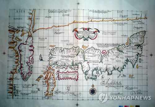
First of all,You can easily find " Mare di Corai" just east of Korea.
Second, it is bit difficult to check, but you can read two "Mare di Giapon", east and west of Kiusiu island.
Their explain finish here.
But...keep serching. Something written right side of double-head bird symbol, draw in the center of this map..

This Korean media photo is vague and difficult to detect what it is written.
So, check more clear image of very similar Dudley 1646 map stoared in Finland natinale library.
Click here to Finland national digital archive http://www.doria.fi/handle/10024/59106
Then choose P105-106 _kr201619_maps12.pdf (12.66MB)
Quote;http://uni.2ch.net/test/read.cgi/newsplus/1334486803/175

Again, something is written right side of double-head bird symbol
。
”Il Mare Il Mare Sewenvorionale de lappone o Giappone”
(North Japan or habon Sea)
Yes, this map says Sea of Japan is "NORTH SEA OF JAPAN"
"Mare di Corai " is drawn at the just a east coast of Corean peninsula. It is not the position of Sea of Japan.
Yes, now you realise that stupid revisionist Korean Kim Munguil's typical method of historical distorture. He use vague map images and wrong map explanation to decieve Korean and world wide people with WICKED AMBITIOUS to justifies historical distorture for Korean national pride!
Ok, let me check other Dudley's 1646 map.
http://seaofjapan-noeastsea.blogspot.jp/2008/12/mer-du-co...
1646. ASIA CARTA DI CIASETE PIU MODERNA by R.Dudley
you can check the word of "Mer de corai" at the east coastal area of Chosun(Korean) peninsula and " Oceano Boriane Del Gappone" at Sea of Japan position.
That is to say, judging from those two Dudley's map , "Mare di Corai" means not the Sea of Japan today . It is just shows just a "East Coast of Korean peninsula".
I really don't understand why Korean scholor always abuses those stupid method of historical distorture and trimming. Shame on him.
I know everone here already underestand "the name of Sea of Japan" is NOT from the Japan's annexatin of Korea on 1910. the explorer La Perouse and Krusenstern who sailed around Sea of Japan and Korean coast, they draw two sea name, One is "Sea of Japan" and the other is "Strait of Korea" and makes it grobal standard around 1780-1830. La Perouse and Krusenstern established the definiation of Sea of Japan today, that is to say, Sea of Japan is the sea between
Tartary Str, La Perouse Str, Tsugar Str, Strait of Korea today.
On the other hand , Mer du Coree finally transformed to Brougton bay, and East Korean gulf today. Korea should rename East Korean Gulf to "East Sea" if they want. But,,,it is nonsense and arrogant claim they request name change of the Sea of Japan .
http://english.yonhapnews.co.kr/news/2012/04/15/0200000000AEN20120415000400315.HTML
Korea finds 17th century marine chart depicting Sea of Korea
SEOUL, April 15 (Yonhap) -- South Korea has found a 17th century nautical chart made by a British explorer marking the expanse of water between Korea and Japan as the Sea of Korea.The chart drawn by Sir Robert Dudley in 1646 was revealed just a week ahead of a general assembly meeting of the International Hydrographic Organization (IHO) scheduled for April 23 through 27 in Monaco, which may possibly change the name of the waters currently named as the Sea of Japan.
Anyway there are the Mateo Ricci map published on 1602 which draws Sea of Japan already.
I DONT KNOW WHY THEY DONT ATTACHED THE EVIDENCE OF MAP ON ENGLISH EDITION NEWS??? IT IS BECAUSE THOSE CHEATING EASILY DETECTED BY EUROPEAN! LOL
Accordnig to Korean and Japanese Yonhap news, "Sea of Korea" on the Sea of Japan and "Sea of Japan" on the southwest and east of Japan Kiusiu island.
http://japanese.yonhapnews.co.kr/relation/2012/04/15/0400000000AJP20120415000800882.HTML
今回確認された内容は「海の神秘」の「アジア海図17章」に描かれたもので、現在の韓国東側海域を「韓国海」と表記し、日本の鹿児島南端海域を「日本海」と表記している。
(Translate;Today he confiemd that "mistery of the Sea, chapter 17 chart of Asia countries which draws "Sea of Korea" on east korean peninsula and "Sea of Japan" on the South of Kiusiu (kagosima) island")
OK lets check this map!
The map from Yonhap news
First of all,You can easily find " Mare di Corai" just east of Korea.
Second, it is bit difficult to check, but you can read two "Mare di Giapon", east and west of Kiusiu island.
Their explain finish here.
But...keep serching. Something written right side of double-head bird symbol, draw in the center of this map..

This Korean media photo is vague and difficult to detect what it is written.
So, check more clear image of very similar Dudley 1646 map stoared in Finland natinale library.
Click here to Finland national digital archive http://www.doria.fi/handle/10024/59106
Then choose P105-106 _kr201619_maps12.pdf (12.66MB)
Quote;http://uni.2ch.net/test/read.cgi/newsplus/1334486803/175

Again, something is written right side of double-head bird symbol
。
”Il Mare Il Mare Sewenvorionale de lappone o Giappone”
(North Japan or habon Sea)
Yes, this map says Sea of Japan is "NORTH SEA OF JAPAN"
"Mare di Corai " is drawn at the just a east coast of Corean peninsula. It is not the position of Sea of Japan.
Yes, now you realise that stupid revisionist Korean Kim Munguil's typical method of historical distorture. He use vague map images and wrong map explanation to decieve Korean and world wide people with WICKED AMBITIOUS to justifies historical distorture for Korean national pride!
Ok, let me check other Dudley's 1646 map.
http://seaofjapan-noeastsea.blogspot.jp/2008/12/mer-du-co...
1646. ASIA CARTA DI CIASETE PIU MODERNA by R.Dudley
you can check the word of "Mer de corai" at the east coastal area of Chosun(Korean) peninsula and " Oceano Boriane Del Gappone" at Sea of Japan position.
That is to say, judging from those two Dudley's map , "Mare di Corai" means not the Sea of Japan today . It is just shows just a "East Coast of Korean peninsula".
I really don't understand why Korean scholor always abuses those stupid method of historical distorture and trimming. Shame on him.
I know everone here already underestand "the name of Sea of Japan" is NOT from the Japan's annexatin of Korea on 1910. the explorer La Perouse and Krusenstern who sailed around Sea of Japan and Korean coast, they draw two sea name, One is "Sea of Japan" and the other is "Strait of Korea" and makes it grobal standard around 1780-1830. La Perouse and Krusenstern established the definiation of Sea of Japan today, that is to say, Sea of Japan is the sea between
Tartary Str, La Perouse Str, Tsugar Str, Strait of Korea today.
On the other hand , Mer du Coree finally transformed to Brougton bay, and East Korean gulf today. Korea should rename East Korean Gulf to "East Sea" if they want. But,,,it is nonsense and arrogant claim they request name change of the Sea of Japan .
4/12/2012
Korean media: East Sea rename lobby are going to fail on IHO
According to the Korean media, Korean are going to give up their anti-Japan brainwashed propaganda of "East Sea" and now undertaking new propaganda "Sea of Korea"
(I dont know why Jonngairbo dont report this news on english edition?)
2012/04/12
http://japanese.joins.com/article/327/150327.html?servcode=A00§code=A10
Related news;Korean media: East Sea rename going to fail on IHO and United States
Korea times 2012/03/25 Korean lobby against White house.
http://dc.koreatimes.com/article/719289
Korea times 2012/03/27 US reconfirms single-name of "Sea of Japan"
http://ny.koreatimes.com/article/719808
Yonhapnews 2012/04/04 Korean lobby against USBGN
http://www.yonhapnews.co.kr/international/2012/04/04/0601180100AKR20120404069200009.HTML
中央日報/韓国語(2012/04/10 09:57) IHO are going to use only Sea of Japan?
http://article.joinsmsn.com/news/article/article.asp?total_id=7854685
Serchina@ 2012/04/10 Sea of Japan/East Sea plural description going to fail on IHO
東海併記「事実上失敗」…IHO総会で紛争化を目指す=韓国
http://news.searchina.ne.jp/disp.cgi?y=2012&d=0410&f=national_0410_023.shtml
Sea of Japan had been common after La Peoruse's circumnavigation and reported "Strait of Korea" and "Sea of Japan". "Sea of Korea" had been disappeared after La Perouse navigation but some map use it to show it as "Broughton Bay"- today's East Korean gulf. The solution of this naming dispute , I suggest, Korean must give up rename Sea of Japan, and Korea rename "East Korean gulf " to East Sea.
http://seaofjapan-noeastsea.blogspot.jp/2008/12/mer-du-coree-is-broughton-bay-not-area.html
4/01/2012
Brainwashed Korean student performance!
People who read my blog had already realise that the name of "Sea of Japan" become internatinal standard by the La perouse and Krusenstern's ages and Great Korean Imprerial (Daehan Imperial) also use the name of Sea of Japan before annexation of Korea.
Sadly, there still have a korean who can't accept the fact and believe Korean brainwashed Anti-Japan fabricated Propagandas incruding Takeshima illegal invasion and Sea of Japan naming dispute.
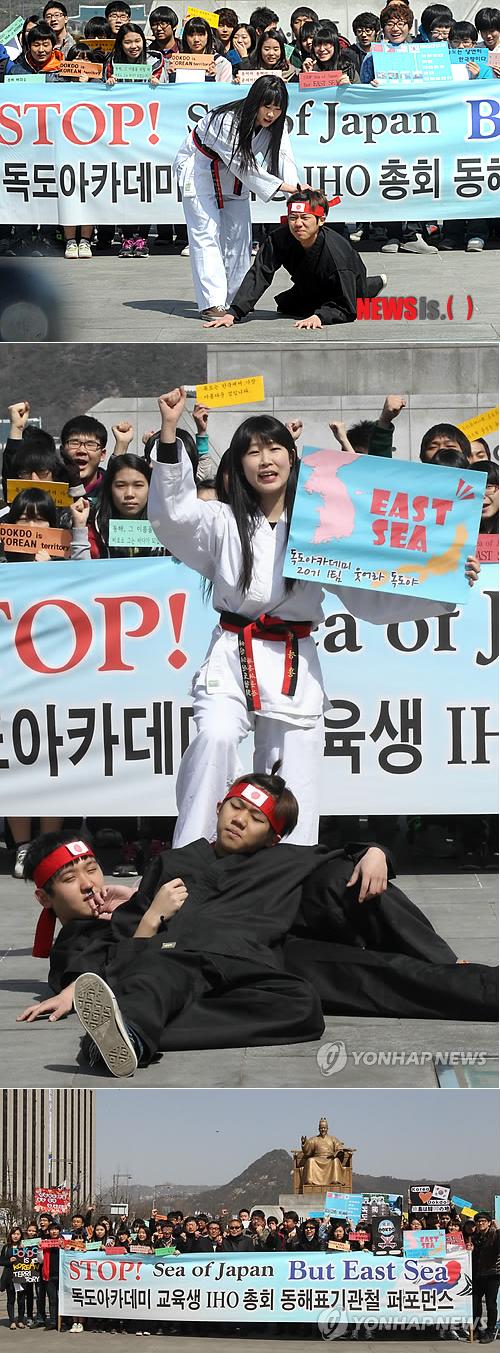
There are brainwashed extreme-natinalist Korean students protest against Sea of Japan.
They perform offensive protest against Japan with hatred.
I had just thought it is April fool joke....But it is real news lol.
http://news.naver.com/main/read.nhn?mode=LSD&mid=sec&sid1=102&oid=003&aid=0004419276
(Seoul-Newsis) report; Park Sunfung. 1st of April there are a protest against State of department and MOFA of UK which decide single-name description of "the Sea of Japan". at the Kuanfa-gate park.
【ソウル=ニューシス】パク・サンフン記者= 1日午前ソウル、光化門(クァンファムン)広場で独島(ドクト)アカデミー教育生が'SEA OF JAPAN'単独表記を支持した米国務省と英国外務省を糾弾するパフォーマンスを行って東海(日本海)を'EAST SEA'で表記することを促している。

Sadly, there still have a korean who can't accept the fact and believe Korean brainwashed Anti-Japan fabricated Propagandas incruding Takeshima illegal invasion and Sea of Japan naming dispute.
There are brainwashed extreme-natinalist Korean students protest against Sea of Japan.
They perform offensive protest against Japan with hatred.
I had just thought it is April fool joke....But it is real news lol.
http://news.naver.com/main/read.nhn?mode=LSD&mid=sec&sid1=102&oid=003&aid=0004419276
(Seoul-Newsis) report; Park Sunfung. 1st of April there are a protest against State of department and MOFA of UK which decide single-name description of "the Sea of Japan". at the Kuanfa-gate park.
【ソウル=ニューシス】パク・サンフン記者= 1日午前ソウル、光化門(クァンファムン)広場で独島(ドクト)アカデミー教育生が'SEA OF JAPAN'単独表記を支持した米国務省と英国外務省を糾弾するパフォーマンスを行って東海(日本海)を'EAST SEA'で表記することを促している。
O B E Y
NEVER TRUST HISTORICAL PRIMARY SOURCES ON YOUR EYES
BELIEVE THAT YOU ARE TOLD IN KOREAN SCHOOL
BELIEVE THAT SHIN YEONNG-HA AND DR.YELLOW
Brainwash IN KOREA
http://www.youtube.com/watch?v=aAK64INxLWk

NEVER TRUST HISTORICAL PRIMARY SOURCES ON YOUR EYES
BELIEVE THAT YOU ARE TOLD IN KOREAN SCHOOL
BELIEVE THAT SHIN YEONNG-HA AND DR.YELLOW
Brainwash IN KOREA
http://www.youtube.com/watch?v=aAK64INxLWk
登録:
投稿 (Atom)


