Author: Bering Sea Tribunal of Arbitration; Bering Sea Commission, 1892
Publisher: Washington, Govt. print. off.
11/03/2012
Memo;Survey of India
Survey of India
http://www.surveyofindia.gov.in/
The Survey of India (Hindi: भारतीय सर्वेक्षण विभाग ) is India's central engineering agency in charge of mapping and surveying. Set up in 1767 to help consolidate the territories of the British East India Company, it is one of the oldest Engineering Departments of the Government of India
http://en.wikipedia.org/wiki/Survey_of_India
Indian Naval Hydrographic Department
http://www.hydrobharat.nic.in/
The Indian Naval Hydrographic Department (INHD) functions under the Chief Hydrographer to the Government of India. The Department, being the nodal agency for Hydrographic surveys and Nautical charting in India, has a very well established organizational setup. INHD has nine indigenously built modern survey ships including one Catamaran Hull Survey Vessel ((CHSV) fitted with state-of-the-art surveying equipment and a well established 'National Institute Hydrography' which is recognized as the Centre for Imparting Training in Hydrography' for South East Asia by IHO.
The Indian express;India’s official mapmaker does not recognise Sea of Japan, irks Tokyo
http://www.indianexpress.com/news/india-s-official-mapmaker-does-not-recognise-sea-of-japan-irks-tokyo/1023339/
9/23/2012
1885.La Coree - Paul Tournafond.
La Coree
Paul Tournafond.
Paris, 1885
this book also write it "MER DU JAPON" (Sea of Japan) the sea between Korea,tartary and Japan. Aye, this book published on 1885 , it is earlier than Japan annexed Korea on 1910. So Korean claim which "the name of Sea of Japan established under the colonial rule of Korea", is distorture.
page i
http://books.google.co.jp/books?id=bBH19xKvw94C&q=japon#v=snippet&q=japon&f=false
Le royaume de Coree, situe au nord-est de l'asie, se compose d'une presquile de forme oblongue et d'un nombre assez considerable d'iles semees sur toute sa cote ouest.Il est situe entre 33°15’ et 42°25’ de latitude nord, 122°45’ et 128°30’ de longtitude est de Paris. Nous avons vu qu'il est ferme au nord par la fleuve du Ya-lou-Kiang, qu'il est ferme a nord par le fleuve du Ya-lou-kiang, qui vient se jeter a l'oucst dans la mer Jaune, et par le Mi-Kiang, qui se jette a l'est dans la mer du Japon.
P113
http://books.google.co.jp/books?id=bBH19xKvw94C&q=japon#v=snippet&q=japon&f=false
La Russie prepare en Orient les fondementals D7un empire vaste. Ses posessions, a I'heure presente, se terminent a la frontiere meme de la Coree, depuis que L'Habilete du general Ignatieff a su arracher a la faiblesse de la Chine la posession des immenses territories de la Mandchourie, que baigne a l'est la mer du Japon.
La coree stored in Koreana museum , published on 1894.
http://www.book1950.co.kr/main.html?menu=view&uid=519&category=Geology/Geography
9/17/2012
1890.FROM COREA TO QUELPAERT
Journal of the American Geographical Society, Vol22,1890.
From Corea to Quelpaert Island: In the Footprints of Kublai Khan
C. Chaillé-Long
Page [218] of 218-266 attached map; Sea of Japan.
http://www.jstor.org/stable/196630
Sea of Japan: Sea of Japan
Strait of Korea: Strait of Corea
East Korean sea or gulf or Broughton Bay; Broughton Bay
Yellow Sea : Yellow Sea
Argonaut Island
Dagelet Island
this map also write it "MER DU JAPON" (Sea of Japan) the sea between Korea,tartary and Japan. Aye, this book published on 1890 , it is earlier than Japan annexed Korea on 1910. So Korean claim which "the name of Sea of Japan established under the colonial rule of Korea", is distorture.
From Corea to Quelpaert Island: In the Footprints of Kublai Khan
C. Chaillé-Long
Page [218] of 218-266 attached map; Sea of Japan.
http://www.jstor.org/stable/196630
Sea of Japan: Sea of Japan
Strait of Korea: Strait of Corea
East Korean sea or gulf or Broughton Bay; Broughton Bay
Yellow Sea : Yellow Sea
Argonaut Island
Dagelet Island
 |
this map also write it "MER DU JAPON" (Sea of Japan) the sea between Korea,tartary and Japan. Aye, this book published on 1890 , it is earlier than Japan annexed Korea on 1910. So Korean claim which "the name of Sea of Japan established under the colonial rule of Korea", is distorture.
9/15/2012
West Philippine Sea??? No it is South China Sea!
President Aquino newly claimed the name of West Philippne Sea on 5Sep2012 and refutal claim by Communist China on 13Sep.
http://www.philstar.com/nation/article.aspx?publicationsubcategoryid=63&articleid=848078
BEIJING, Sept. 13 (Xinhua) -- Despite China urging the Philippines to ease tensions over Huangyan Island and promote bilateral ties, the country has officially named maritime areas near its coast, including part of China's territories in the South China Sea, the "West Philippine Sea."
On the other hand, , China's claim is groundless too that they claim "incruding part of China's terrotiries in the South China Sea". Sea name is nothing to do with EEZ or territorial issue.It is just a geographical or hydrographical naming issue. South Korea claims sea name with territorial issue , the illagally assaulted and illegally occupied by Korea, Takeshima(Liancourt Rocks) ,territory of Japan in Japan Sea.

49-South China Sea
On the East: From Tanjong Sambar through the West coast of Borneo to Tanjong Sampanmangio, the North point, thence a line to West Points of Balabac andSecam Reefs, on the West point of Bancalan Island and to Cape Buliluyan, the Southwest point of Palawan, through this island to Cabuli Point, the Northern point thereof, thence to the Northwest point of Busuanga and to Cape Calavite in the island of Mindanao, to the Northwest point of Lubang Island and Point Fuego in Luzon Island, thorugh this island to Cape Engano, the Northeast point of Luzon, along a line joining this cape with the East point of Balintang Island and to the East point of Y'Ami Island thence to Garan Bi, the Southern point of Taiwan (Formosa), through this island to Santryo its North Eastern Point.
On the North: From Fuki kaku the North point of Formosa to Kiushan Tao (TurnabourIsland) on to the South Point of Haitan Tao and thence Westward on the paralell of 25'24 Nort to the coast of Fukien
56-Philippine Sea
Is that area of the North Paicific Ocean off the Eastern coasts of the Philippne Islands, It is bounded;
On the west By the Eastern limits of the East Indian Archipelago (48) South China Sea 849) and the Eastern China Sea (50)
On the East By the ridge joining Japan to the Bonin, Volcano and Ladrone (mariana) islands, all these being included in the Philippine Sea
i can understand phlippine's anger against China commie because they got robbed their schaborough reef by China. but Sea name and territorial dispute should be separated.
Also,United States Board of Geo Name recognized South China Sea is "Approved" name.
http://geonames.nga.mil/ggmagaz/
Aquino signs order on West Philippine Sea
The Philippine Star Updated September 12, 2012 04:30 PM 35 comments to this post
The Philippine Star Updated September 12, 2012 04:30 PM 35 comments to this post
http://www.philstar.com/nation/article.aspx?publicationsubcategoryid=63&articleid=848078
BEIJING, Sept. 13 (Xinhua) -- Despite China urging the Philippines to ease tensions over Huangyan Island and promote bilateral ties, the country has officially named maritime areas near its coast, including part of China's territories in the South China Sea, the "West Philippine Sea."
On the other hand, , China's claim is groundless too that they claim "incruding part of China's terrotiries in the South China Sea". Sea name is nothing to do with EEZ or territorial issue.It is just a geographical or hydrographical naming issue. South Korea claims sea name with territorial issue , the illagally assaulted and illegally occupied by Korea, Takeshima(Liancourt Rocks) ,territory of Japan in Japan Sea.
49-South China Sea
On the East: From Tanjong Sambar through the West coast of Borneo to Tanjong Sampanmangio, the North point, thence a line to West Points of Balabac andSecam Reefs, on the West point of Bancalan Island and to Cape Buliluyan, the Southwest point of Palawan, through this island to Cabuli Point, the Northern point thereof, thence to the Northwest point of Busuanga and to Cape Calavite in the island of Mindanao, to the Northwest point of Lubang Island and Point Fuego in Luzon Island, thorugh this island to Cape Engano, the Northeast point of Luzon, along a line joining this cape with the East point of Balintang Island and to the East point of Y'Ami Island thence to Garan Bi, the Southern point of Taiwan (Formosa), through this island to Santryo its North Eastern Point.
On the North: From Fuki kaku the North point of Formosa to Kiushan Tao (TurnabourIsland) on to the South Point of Haitan Tao and thence Westward on the paralell of 25'24 Nort to the coast of Fukien
56-Philippine Sea
Is that area of the North Paicific Ocean off the Eastern coasts of the Philippne Islands, It is bounded;
On the west By the Eastern limits of the East Indian Archipelago (48) South China Sea 849) and the Eastern China Sea (50)
On the East By the ridge joining Japan to the Bonin, Volcano and Ladrone (mariana) islands, all these being included in the Philippine Sea
i can understand phlippine's anger against China commie because they got robbed their schaborough reef by China. but Sea name and territorial dispute should be separated.
Also,United States Board of Geo Name recognized South China Sea is "Approved" name.
http://geonames.nga.mil/ggmagaz/
9/12/2012
承政院日記粛宗20年5月24日 南九萬蔚陵島問題
http://sjw.history.go.kr/inspection/insp_result.jsp?mode=k&sjwid=SJW-D20051240-01900
承政院日記粛宗20年5月24日
南九万などが入試して朝鮮人が蔚陵島に入らないようにするという倭人の伝言に対して対処する問題に対して議論する
*文献の内容自体はすでに知られているものですが、見える見えないの記述の議論において、どこから何が見えるのか?(半島東岸から鬱陵島がみえる、と文献に書いてあるのか?それとも鬱陵島から竹島が見えると文献に書いてあるのか?)に関係する記述に気がつきましたので貼っておきます。要するに、この文章でも、半島の東岸の大関峯に登れば鬱陵島が見える、と記載があるわけです。
○南九萬曰, 卽見東萊府使狀啓, 則向者倭人來言, 朝鮮人入於五竹島, 此後則無使更入云。彼所謂竹島, 卽我國蔚陵島也。臣見芝峯類說則曰, 倭奴占據礒竹島, 礒竹, 卽蔚陵島也。島一也, 而名稱有異, 彼不曰蔚陵, 而曰竹島者, 此不過厭其有蔚陵之名也。彼漢一出來, 尙可惡說, 再出則其爲害, 將至無窮, 豈不大可慮哉? 臣意則宜遣接慰官, 前去書啓還送事言之。且以回賓作主事, 責之矣。上曰, 予見芝峯類說及輿地圖, 則蔚陵島數字缺飄風人所居之地也。倭人所謂竹島, 必是蔚陵島也。其據名稱說, 意慮巧矣。以此責之, 可也。申汝哲曰, 倭人之據名稱說, 其造意之巧險, 於此可見。若不辨別, 任其所爲, 則彼將來據其地, 略無忌心。其爲貽害, 必至無一字缺矣。柳尙運曰, 彼漢, 一向施惡, 使我國之人, 不得接足於其島, 或有入去者, 則彼必捉送致責, 其弊難支矣。上曰, 若無變通之擧, 則必將有如此之弊矣。南九萬曰, 臣於向者, 登大關嶺, 望見其地勢, 則其島與蔚珍縣相對, 其中多有崇山峻嶺, 地方可百餘里矣。申汝哲曰, 臣適往觀魚臺, 望見其島, 則其間相距, 不甚遼遠, 視若南山之近矣。問諸漁人曰, 汝等漁於彼乎? 答曰, 彼處, 多有大魚, 故時時往漁矣。且其上, 有大木參天, 竹大如杠, 地且沃饒云。彼若知其可居而來據之, 則其附近三陟·江陵等地, 受害必多, 甚可慮也。南九萬曰, 臣見新羅圖, 則此島, 亦有國名, 降新羅納土貢。高麗太祖時, 島人獻方物, 我太宗朝, 不勝倭患, 遣按撫使, 刷出流民, 而空其地。卽今倭人來據, 非但以祖宗之地, 棄與他人, 將來之患, 有不可勝言者矣。更遣接慰官, 前去書狀還送事, 言之, 何如? 上曰, 前去書狀還送事, 送言, 可也。
鬱陵島関連 朝鮮側史料 備忘録
雪汀詩集卷之七 七言律詩 曺文秀
雪汀詩集卷之七 七言律詩 曺文秀
偶題 以下丹陽錄 b_024_475a
此老人稱有僊分。丹陽太守舊蓬萊。只憐衰境從多024_475b病。誰謂明時棄不才。地近十洲邊蔚島。天低百尺上魚臺。治繩於我知何有。高卧河淸但引杯。
忘窩先生文集卷之三 次寄孝徵 金榮祖
忘窩先生文集卷之三 次寄孝徵 金榮祖
關東行盡向僊槎。路幷滄溟萬頃波。今古山河元大地。往來豪傑亦恒沙。開囪俯瞰扶桑日。騁目平臨蔚島霞。彊步君詩留後識。年惟乙亥月淸和。
松沙先生文集卷之十七 烈婦裵氏旌閭重修記 奇宇萬
松沙先生文集卷之十七 (奇宇萬)
烈婦裵氏旌閭重修記 a_345_419d
肅宗辛酉。命旌故判事尹趪妻裵氏之閭。判事公當壬辰燹。舟師勤王。已有定筭。先移其家率于竹島。禦賊于蔚島。 賊衆我寡。被執不屈而死。裵夫人聞變號慟。方欲自裁。猝遇賊大罵。雖亂斫而不少挫。竟被害。少女年僅十四。以身翼蔽。同時遇害。二子之立之發方幼。被俘而 去。至倭橋得逃還。收母屍葬於先塋之側。事行在續三綱。曾孫參奉濟民上言。成命始降。表宅以時擧行。參奉公記其事。年久而閭圮。後孫以今年甲寅重修。秀士 哲成,炫植求爲記事之文。宇萬老且病。不堪爲役。而見今壬辰遺種。其禍有浮。三綱絶矣。臣而忘君者。滔滔皆是。夫忠與烈是一致。判事公之臣死於君。裵夫人之婦死於夫。皆足以樹風聲於後世。而及今而重修。道路改觀。或將爲激勵忠義之一大消息歟。然則先旌重修。雖尹氏一家之私。而寔有補於世風不少也。屢欷而
水村集卷之四 임방(任埅)
水村集卷之四 임방(任埅)
追寄通川守黃翰卿 鎭 別語 a_149_093a
通州絶境飽曾知。請爲吾君賦一詩。叢石亭眞天下勝。金幱窟亦海東奇。層層玉立蓬山近。渺渺萍浮蔚島欹。盡管風煙閒作主。倘非仙分孰能斯。
恬軒集卷之八 西河任相元公輔 登高丘而望遠海行
恬軒集卷之八/詩 西河任相元公輔著
登高丘而望遠海行
登高丘而望遠海行 a_148_226a
海水浸天天正碧。天水茫茫兩無極。三山可望不可到。
安得長風駕兩腋。此中神仙竟有無。但見雲霞日月爭朝夕。
中國之東五臺西。海道約量三千強。徐生騁誕五利誑。
秦皇漢武聞若狂。若登臺山更東臨。又有蔚島橫蒼蒼。
十洲扶桑更何在。夸父渴死章亥僵。九州之外裨海環。此語吾欲徵鄒陽。天風吹雲笙鶴過。仙人向我皆盧胡。渤海天與龍蜃窟。神州地入腥膻區。不知身在蓬萊中。更望東海何其愚。
汾厓遺稿卷二 萊山錄 一
汾厓遺稿卷二/詩○萊山錄 一
萊館謾吟。 二首。
萊館謾吟。 二首。 a_129_334a
萇子千年國。東南傍海濆。颶驚能走石。瘴潤自生氛。市積長崎貨。山連蔚島雲。天涯身到此。衰白日紛紛。
又
郡郭依山麓。蕭條擁小村。雨頻梅結子。煙濕竹生孫。海日官居暖。蠻天野戍昏。倦遊千里客。留滯謾銷魂。
東里集卷之八 登大關嶺 李殷相
東里集卷之八/詩 李殷相
登大關嶺
披蓑嶺下卸征鞍。石逕逶迤百八盤。天設曾爲何代險。氷陰不放去年寒。玄溟波浪杯中瀉。蔚島雲煙脚底看。渺渺鄕關千里隔。心隨西日向長安。
梨山集 角 :送李秀才天駿歸蔚陵島
梨山集 角
送李秀才天駿歸蔚陵島 (作者不詳)
細雨初晴夕日低, 故人南去蔚島棲, 亦知求友鶯遷木, 頻 賀歸程鷰蹴泥, 白雲持贈心還鬱, 明月相思意倍悽, 回頭 悵立春天暮, 垂柳藤蔓一樣齊
竹老先生文集卷之三
http://db.itkc.or.kr/index.jsp?bizName=MM&url=/itkcdb/text/nodeViewIframe.jsp%3FbizName=MM%26seojiId=kc_mm_b131%26gunchaId=av003%26muncheId=02%26finId=004
雜著
書蔚陵島圖後 b_019_045c (著者:申活?)
歲戊申之夏四月旣晦。余往棲于箕城之白巖山。山之絶頂有一菴。名曰桑日。蓋取扶桑日出之義也。觀其東臨大海。一望無際。上天下水。氣像萬千。眞勝境也。遙望東北。有一山聳出於烟海縹緲之中。所謂蔚陵島也。 是日纖雲捲盡。天朗氣淸。玉峀瑤岑。壁立雲表。千奇萬狀。箇箇呈露。或如三軍奮躍。劒戟交森。或如羣鯨噴海。怒鬣縱橫。或如層雲潑墨。疊影紛披。其餘獻奇 於眼前境019_045d界者不可一二計。何造化手段若是之奇巧也。世傳漢武帝求神仙。東廵海上。至碣石而還。安知一時迂怪之輩。指此爲蓬萊。使之候仙於 玆山也邪。噫三十六洞天。無則已。有則此山當爲之第一。若借得一片風帆。使鯤鵬翼舲。鯨鯢皷柁。萬里烟波。一瞬飄到。則紫府丹丘。擧足可躡。夫根月窟。翻 手可攀。蘇仙駕鶴之遊。博望乘槎之問。不期而當我之前矣。然後招王喬訪安期。共坐支機石上。吸盡無限金華。以資桑楡一半糧料。則可以凌霄漢出宇宙。俯視塵 寰。不知隔幾重雲水邪。顧以塵繮縛人。凡骨未蛻。咫尺崑崙。仙路杳茫。誠可以睹北嶽山019_046a靈之譏。發千古眞人之歎矣。雖然與其騁想於無何之 域。而取必於不可必之事。莫如收拾奇觀。幻諸一幅霜綃。掛之中堂。收入雙眸。則十洲三島之勝。自然森列於几案之間。而其得於胷次者。亦將助發吾浩然之氣 矣。豈特巍然其高。坎然其深者。只爲悅目喪心之具而已哉。然則其必有翫而樂之者矣。其必有樂而不知老之將至者矣。於是使山僧摸得一本而藏之。且書四韻詩二 絶。以爲他日遣懷之一資云。
鬱陵島関連 日本史料 備忘録
1872.副島種臣に与へて朝鮮地図の件を問合する書面
西郷南洲書簡集 図書 加治木常樹 編 (実業之日本社, 1911)
http://kindai.ndl.go.jp/info:ndljp/pid/781419/101
1872.09.25
御壮剛奉恐賀候、池上四郎、煙台より九月二十五日仕出之書簡
省より御居被下候所、封中に朝鮮朝鮮地図差遣候趣、申来候得共、不相
見得候に付、御省え差出もの欺もも不被測候に付、相居候哉、卒度御
尋申上候将又別神御序之節、何卒相屈候様、御取計被下度御願申
上候、此段乍略儀御頼旁奉得貴意候頓首
解説 煙台は芝?の別名なり、五年の秋池上四郎より南洲宛の書簡、外務省へ届きたるを、南洲に伝送したるに対し、折返して、地図の事を問い合わせたるなり
*この書簡に書かれた地図はどのようなものなのかが不明
九月二十五日、四郎、外務省経由で西郷に書簡と朝鮮地図を送る(『西郷隆盛全集』第三巻、八一)
http://www16.ocn.ne.jp/~hideumi/index3.html
1925.明け行く朝鮮
著者 松村松盛
出版地 (publicationPlace) 東京
出版者 (publisher) 帝国地方行政学会
http://kindai.ndl.go.jp/info:ndljp/pid/983121/148
鬱陵島紀行
1931.5 島めぐり
島めぐり
西亀正夫 著 著者 1883-1945
出版地 東京 出版者 厚生閣書店
日本海の島 鬱陵島 お銭の無い国 獅子をつれて征伐
朝鮮の東岸、江原道の海岸からざつと百三十キロを離れた東方海上にあり、ぼつり
と浮かんでいるたったひとつの離れ小島、これこそは朝鮮の名で鬱陵島、日本名は
松島と呼ばれる島です。
それは東西の直径も南北の直径もともに十キロばかりの四角形に近い島です。
広いに日本海のただ中にあって、
1932.偉人伝全集. 第12巻
第11 長崎留守訳時代の岩崎弥太郎
「鬱陵島占領計画の失敗」
白柳, 秀湖, 1884-1950 東京 出版者 (publisher) 改造社
http://kindai.ndl.go.jp/info:ndljp/pid/1186605/113
その頃長崎に白楽と呼ぶ朝鮮人が居て少しは文字を解し酒間の斡旋くらい は出来た。弥太郎はこの白楽と、對週の浪士天草二郎(著者註:多分辮名であらう)と呼ぶものを介して識合になつた。筆談は弥太郎の得意とする所であったか ら、弥太郎はこの白楽からだんだんと朝鮮の事情を知ることが出来た
後日、英船を雇い、かの天草二郎を通辮件案内役として先ず鬱陵島(竹島)に渡り、材木を伐出したる後朝鮮京城に入り、国王に謁見して牛皮の交易を出願する目的であったのことだった
8/28/2012
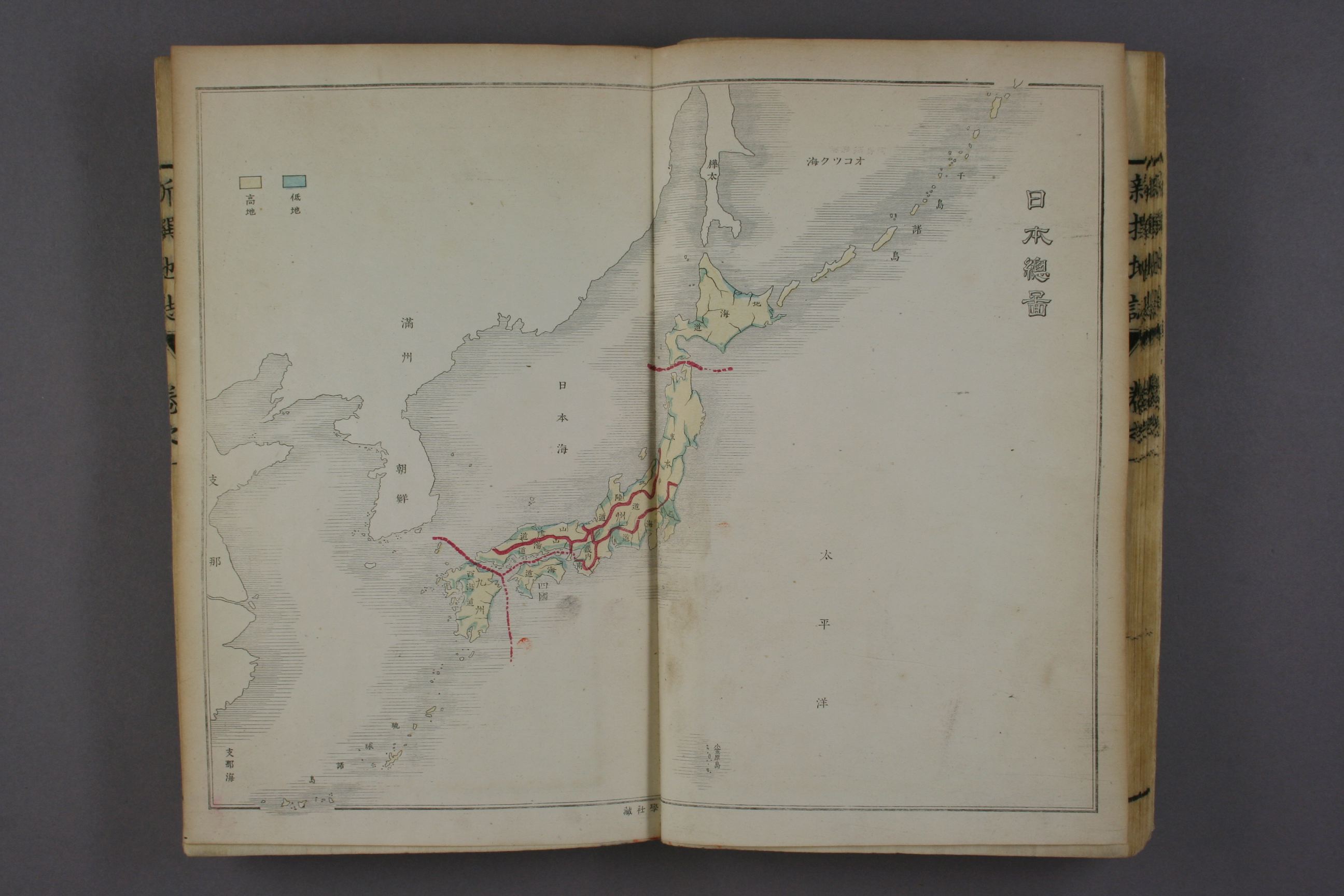
1887.岡村松太郎編纂‘新撰地誌
1887.岡村松太郎編纂‘新撰地誌 (Okamura Matsutaro, New Geography)
巻1:日本総図(vol1: outline map of Japan):日本海(Sea of Japan)
(stored in Washeda Univ. Library)
1888:青木恒三郎 分邦詳密日本地図
1888:青木恒三郎 分邦詳密日本地図 ;日本海(Sea of Japan)
http://kindai.ndl.go.jp/info:ndljp/pid/767761/7
Btw, Korean media distorts there are Ulleungdo and Liancourt Rocks(=Takeshima) on this map, is wrong
http://www.munhwa.com/news/view.html?no=2012082801030143186004
It is appear that the two island in the sea of Japan, one is Argonaut island and the other is Dagelet-Ulluengdo and It is not Liancourt Rocks on this map.
https://sites.google.com/site/takeshimaliancourt/Home/Korean-media-black-propaganda/20120828
Google Earth Argonaut-Dagelet-Liancourt Rocks Position check tool; (download; no virus)
Moreover, there are many Japanese map on Meiji era which describes Liancourt Roocks(Takeshima).
7/28/2012
1915.韓国痛史(Painful History of Korea)
Painful History of Korea (韓国痛史) by Park Eun-sik(朴殷植)
There are a book titled "Painful history of Korea" by Park Eun-sik who is independent movemennt activist. Even Korean independentist use the name of Sea of Japan and he distinguish Korean coast and the deep sea -Sea of Japan.
According to the articles by Prof Shimojo and Sen.Sindo, Korean recognizes east coastal water and deep sea are different, east coast and the Sea of Japan witten in Painful History of Korea.
「韓国は亜細亜東南の突出に在る半島国なり。その境界は東、滄海に濱(沿って)日本海を隔て、西は黄海に臨んで中国の山東江蘇二省に対す」
"Korea is the peninsula country at the southeast of Asia. There are east boundary of Blue Sea which separate to the Sea of Japan, west one of Yellow Sea,to the China's two proince-Shandong and Jiangsu."
reference;
実事求是第35回 竹島問題の封印策としての「東海」呼称について
http://www.pref.shimane.lg.jp/soumu/web-takeshima/takeshima04/takeshima04-2/takeshima05-q.html
A Study of the Naming Issue of Japan Sea Yoshitaka Shindo Member of the House of Representatives National Diet of Japan
http://www.shindo.gr.jp/%E8%B3%87%E6%96%99%E4%B8%80%E5%BC%8F%EF%BC%88%E7%B1%B3%E5%9B%BD%E3%81%82%E3%81%A6%EF%BC%89.pdf
There are another korean records textbook written by Korean before the annexation, which distinguish east coast and the deep sea of Japan Sea.
1909.1910.
(新訂)中等萬國新地志 金鴻卿 編纂 廣學書館
http://seaofjapan-noeastsea.blogspot.jp/2009/07/1907.html
第二章 亜細亜 (Second chapter;Asia)
第一節 総論 (First Section: general)
沿海 P52 (Coastal sea)
%E4%B8%AD%E7%AD%89%E8%90%AC%E5%9C%8B%E6%96%B0%E5%9C%B0%E5%BF%97.jpg)
reference;
実事求是第35回 竹島問題の封印策としての「東海」呼称について
http://www.pref.shimane.lg.jp/soumu/web-takeshima/takeshima04/takeshima04-2/takeshima05-q.html
A Study of the Naming Issue of Japan Sea Yoshitaka Shindo Member of the House of Representatives National Diet of Japan
http://www.shindo.gr.jp/%E8%B3%87%E6%96%99%E4%B8%80%E5%BC%8F%EF%BC%88%E7%B1%B3%E5%9B%BD%E3%81%82%E3%81%A6%EF%BC%89.pdf
There are a book titled "Painful history of Korea" by Park Eun-sik who is independent movemennt activist. Even Korean independentist use the name of Sea of Japan and he distinguish Korean coast and the deep sea -Sea of Japan.
According to the articles by Prof Shimojo and Sen.Sindo, Korean recognizes east coastal water and deep sea are different, east coast and the Sea of Japan witten in Painful History of Korea.
「韓国は亜細亜東南の突出に在る半島国なり。その境界は東、滄海に濱(沿って)日本海を隔て、西は黄海に臨んで中国の山東江蘇二省に対す」
"Korea is the peninsula country at the southeast of Asia. There are east boundary of Blue Sea which separate to the Sea of Japan, west one of Yellow Sea,to the China's two proince-Shandong and Jiangsu."
reference;
実事求是第35回 竹島問題の封印策としての「東海」呼称について
http://www.pref.shimane.lg.jp/soumu/web-takeshima/takeshima04/takeshima04-2/takeshima05-q.html
A Study of the Naming Issue of Japan Sea Yoshitaka Shindo Member of the House of Representatives National Diet of Japan
http://www.shindo.gr.jp/%E8%B3%87%E6%96%99%E4%B8%80%E5%BC%8F%EF%BC%88%E7%B1%B3%E5%9B%BD%E3%81%82%E3%81%A6%EF%BC%89.pdf
If someone have a screenshot of Painful history of Korea, pls advice. thank you.
There are another korean records textbook written by Korean before the annexation, which distinguish east coast and the deep sea of Japan Sea.
1909.1910.
(新訂)中等萬國新地志 金鴻卿 編纂 廣學書館
http://seaofjapan-noeastsea.blogspot.jp/2009/07/1907.html
第二章 亜細亜 (Second chapter;Asia)
第一節 総論 (First Section: general)
沿海 P52 (Coastal sea)
日本海、渤海、黄海、東海、朝鮮海(別称蒼海)、支那海、逞羅湾
..............................................................................
右諸海中、北氷洋 舟編 不通●●●●海●●●日本海.....
Japan Sea, Bol-hae,Yellow Sea, East Sea(*East China Sea?), Korean Sea(another name;Blue Sea) and China Sea (south china Sea*), Gulf of Siam,
...........................................................................
in those sea at the north Pacific.................Sea of Japan.
%E4%B8%AD%E7%AD%89%E8%90%AC%E5%9C%8B%E6%96%B0%E5%9C%B0%E5%BF%97.jpg)
reference;
実事求是第35回 竹島問題の封印策としての「東海」呼称について
http://www.pref.shimane.lg.jp/soumu/web-takeshima/takeshima04/takeshima04-2/takeshima05-q.html
A Study of the Naming Issue of Japan Sea Yoshitaka Shindo Member of the House of Representatives National Diet of Japan
http://www.shindo.gr.jp/%E8%B3%87%E6%96%99%E4%B8%80%E5%BC%8F%EF%BC%88%E7%B1%B3%E5%9B%BD%E3%81%82%E3%81%A6%EF%BC%89.pdf
7/25/2012
1903. 韓海通漁指針 (Korean coast Fishery guideline)
1903. 『韓海通漁指針』葛生修亮 (Korean coast Fishery guideline)
http://kindai.ndl.go.jp/info:ndljp/pid/802140/109
This book explains that "East Sea" is just a one part of "Sea of Japan",big marginal sea between Siberial, Korea and Honsyu island of Japan.
東海ー東北咸鏡道の豆満江より東南慶尚道釜山付近に至る沿海を指す。
East coast is the Coastal area between Tumen_River ,Hamgyong Province to Busan, Gyeongsang Province.
ここ地方は朝鮮西函比利亜及我が本州と相 ?みて、一大内海を形成せる日本海の一部なるが故に、
These region( East Sea) is a one part of Sea of Japan the marginal sea between Korea, Siberia and Honsyu island of Japan, ,
attached map;韓海沿岸略図 (Brief map of Korean coast)
http://kindai.ndl.go.jp/info:ndljp/pid/802140/1
broughton bay- 朝鮮海湾 (Korean sea gulf)
http://kindai.ndl.go.jp/info:ndljp/pid/802140/2
Sea of Japan- 日本海(Sea of Japan)
Yellow Sea- 黄海 (Yellow Sea)
実事求是第35回 竹島問題の封印策としての「東海」呼称について
http://www.pref.shimane.lg.jp/soumu/web-takeshima/takeshima04/takeshima04-2/takeshima05-q.html
A Study of the Naming Issue of Japan Sea Yoshitaka Shindo Member of the House of Representatives National Diet of Japan
http://www.shindo.gr.jp/%E8%B3%87%E6%96%99%E4%B8%80%E5%BC%8F%EF%BC%88%E7%B1%B3%E5%9B%BD%E3%81%82%E3%81%A6%EF%BC%89.pdf
http://kindai.ndl.go.jp/info:ndljp/pid/802140/109
This book explains that "East Sea" is just a one part of "Sea of Japan",big marginal sea between Siberial, Korea and Honsyu island of Japan.
東海ー東北咸鏡道の豆満江より東南慶尚道釜山付近に至る沿海を指す。
East coast is the Coastal area between Tumen_River ,Hamgyong Province to Busan, Gyeongsang Province.
ここ地方は朝鮮西函比利亜及我が本州と相 ?みて、一大内海を形成せる日本海の一部なるが故に、
These region( East Sea) is a one part of Sea of Japan the marginal sea between Korea, Siberia and Honsyu island of Japan, ,
attached map;韓海沿岸略図 (Brief map of Korean coast)
http://kindai.ndl.go.jp/info:ndljp/pid/802140/1
broughton bay- 朝鮮海湾 (Korean sea gulf)
http://kindai.ndl.go.jp/info:ndljp/pid/802140/2
Sea of Japan- 日本海(Sea of Japan)
Yellow Sea- 黄海 (Yellow Sea)
 |
実事求是第35回 竹島問題の封印策としての「東海」呼称について
http://www.pref.shimane.lg.jp/soumu/web-takeshima/takeshima04/takeshima04-2/takeshima05-q.html
A Study of the Naming Issue of Japan Sea Yoshitaka Shindo Member of the House of Representatives National Diet of Japan
http://www.shindo.gr.jp/%E8%B3%87%E6%96%99%E4%B8%80%E5%BC%8F%EF%BC%88%E7%B1%B3%E5%9B%BD%E3%81%82%E3%81%A6%EF%BC%89.pdf
6/30/2012
Answer to the Petition on the Sea of Japan naming issue by WhiteHouse
There are a petition both Japanese and Korean about Sea of Japan naming dispute in White house petition site. Korean abuses fake propaganda about distorted Propagnada of anti-Sea of Japan.
.Unted States replies the answer to Japanese and Korean about single-ocean-name usage policy and Sea of Japan is right term and explained that United States historicall use the name of sea of Japan long years.
White house's statement is reasonable because Commander Mattew Perry aboarding the USS Sasquehana to Japan on 1855 they already use the name of Sea of Japan in their navy chart. Also Korean use the name of Sea of Japan before annexation , e,g their text book published on1895. Those histical records totally denies korean fake propaganda claims which the name of Sea of Japan established after the annexation of Korea.
http://seaofjapan-noeastsea.blogspot.jp/2012/04/korean-revisionist-petition-filled-up.html
There are my personal solution against naming dispute of the name of Sea of Japan here.
http://seaofjapan-noeastsea.blogspot.jp/2012/05/solution-of-sea-of-japan-naming-dispute.html
The text below is the answer to those petition about Sea of Japan and anti-Sea of Japan Quote from:.http://www.whitehouse.gov/blog/2012/06/29/response-we-people-petition-sea-japan-naming-issue?utm_source=wh.gov&utm_medium=shorturl&utm_campaign=shorturl
-------------------------------------------------------------------
Response to We the People Petition on the Sea of Japan Naming Issue
By Kurt CampbellThank you for using the "We the People" platform to express your views on the usage of the term "Sea of Japan."
View this response in Korean | View this response in Japanese.
It is longstanding United States policy to refer to each sea or ocean by a single name. This policy applies to all seas, including those bordered by multiple countries that may each have their own names for such bodies of water. Concerning the body of water between the Japanese archipelago and the Korean peninsula, longstanding U.S. policy is to refer to it as the "Sea of Japan." We are aware the Republic of Korea refers to the body of water as the "East Sea," and the United States is not asking the Republic of Korea to change its nomenclature. U.S. usage of the "Sea of Japan" in no way implies an opinion regarding any issue related to sovereignty.
We understand that this naming issue is an important and sensitive one for both the Republic of Korea and Japan. I assure you the United States remains committed to our deep and indispensable alliances with the Republic of Korea and Japan, relationships based on shared values and mutual trust. We will continue to work with the Republic of Korea and Japan to address regional and global challenges together.
Kurt M. Campbell is Assistant Secretary of State for East Asian and Pacific Affairs
Tell us what you think about this petition and We the People.
Korean translation of response:
일본해 명명 표기 관련 위더피플 청원에 대한 회신
작성: 커트 캠벌
"일본해"라는 용어 사용에 관한 귀하의 의견을 밝히고자 “위더피플”의 플랫폼을 이용해 주셔서 감사합니다.
각각의 바다, 또는 해양을 하나의 이름으로 지칭하는 것은 미국의 오랫동안에 걸친 방침입니다. 이 방침은 모든 바다에 적용하므로, 각국의 고유한 수역 이름을 가질 수 있는 다수 국가의 국경에 접하는 경우도 포함합니다. 일본 열도와 한반도 사이에 있는 수역에 관하여, 미국의 오랜 방침은 "일본해"로 지칭하는 것입니다. 우리는 대한민국이 그 수역을 "동해"로 지칭하고 있음을 인지하고 있으며, 미국은 대한민국으로 하여금 그 명명을 변경하도록 요구하지 않습니다. 미국의 "일본해" 명칭 사용은 국가 주권에 관련된 어떤 사안에서 그에 관한 의견을 함축하는 것은 결코 아닙니다.
저희는 이 명명에 관한 사안이 대한민국과 일본 양국에 모두 중요하며 민감한 문제라는 것을 이해하고 있습니다. 본인은 귀하에게 미국은 대한민국 및 일본과의 깊고도 긴요한 동맹 관계와 공유한 가치 및 상호 신뢰를 바탕으로 한 국가 관계를 계속 지켜나갈 것을 이에 분명히 다짐하는 바입니다. 저희는 대한민국 및 일본과 함께 지역적으로나 세계적으로 어려운 문제에 공동으로 대처하는 노력을 계속할 것입니다.
커트 엠. 캠벌은 동아시아 태평양지역 담당 국무부 차관임.
Japanese translation of response:
日本海命名問題に関する 人民陳情に対する回答
カート・キャンベル執筆
「我ら人民」のプラットフォームを使って、「日本海」という言葉の使用に関する見解を表明していただいて、ありがとうございます。
各々の海洋を単一の名称で言及することは、米国の長年にわたる方針です。この方針は全ての海洋に適用されており、その中にはこうした水域についてそ れぞれ独自の名称をつけている複数の国々の国境が接している海域も含まれます。日本列島と朝鮮半島の間にある水域については、「日本海」と呼ぶのが長年に わたる米国の方針です。我々は、韓国が同水域を「東海」と呼んでいることに気付いており、米国は韓国にその命名法を変更するよう求めてはいません。米国が 「日本海」という名称を使用することは主権に関連した何らかの問題についての意見を示唆するものではありません。
我々は、この命名問題が韓国と日本両国にとって重要で慎重に扱うべき問題であることを理解しています。米国が韓国と日本との深くかけがえのない同盟 関係、共有する価値観と相互信頼に基づく関係に対するコミットメントを維持し続けていくことを、私は保証します。我々は、地域的・世界的な挑戦課題に共に 対処するため、韓国および日本と協力し続けます。
カート・M・キャンベルは、東アジア太平洋問題担当の国務次官補である。
5/31/2012
IHO S-23WG draft summery record
XVIIIth INTERNATIONAL HYDROGRAPHIC CONFERENCE DRAFT SUMMARY RECORD OF THE SECOND PLENARY SESSION
23 April 2012 1410-1730
The Conference took note of the report.
Report on work to revise IHO Publication S-23 – “Limits of Oceans and Seas”
The PRESIDENT invited comments on the report as a whole and, in particular, on the issues relating to the future of Publication S-23
Captain KORTENOEVEN (Netherlands) reiterated that his country took no position, as before, on the naming of the sea area between the Japanese archipelago and the Korean peninsula.
Dr Shigeru KATO (Japan) (made a statement1.)
IGA FRACHON (France) said that, in the absence of an agreed technical approach, he could not express a view on any specific dispute over the naming of an area. In view of the need for a publication to be used for cartographic and hydrographic purposes, he hoped that the interested parties could resolve their dispute so that consensus could be reached on a new edition of Publication S-23. Given the importance of IHO’s numerous other commitments, he recommended that the resources devoted to the question of updating the publication should be limited until either the dispute had been resolved or a general methodology had been approved.
Ambassador PAIK (Republic of Korea) made a statement1.
Mr. KIM (Democratic People’s Republic of Korea) made a statement2.
Rear Admiral ANDREASEN (United States of America) expressed his country’s view that Publication S-23 was an important reference for Member States in the publication of charts and related documentation, for mariners to know which sea areas they were in, and for all those involved in marine Geographic Information Systems. It established the technical boundaries of the areas concerned and, in the absence of a new edition, there could be still further politicization of our work through national adoption of politically derived limits rather than unique water bodies defined by coastal shapes or unique oceanographic character such as the Antarctic Convergence zone limit of the Southern Ocean. The United States does not want to see “no” S-23. He was therefore in favour of pursuing work on the revision of S-23. However, that work had been in progress for 35 years and not a single page had yet been updated. In his country’s view, that reflected badly on IHO, an organization which it held in the highest regard. The United States considers it important to find an acceptable way forward. In view of the failure to revise the publication as a whole he therefore suggested adopting a high-level approach, on a chapter-by-chapter basis, which could lead to the revision of a significant number of chapters. A proposal along those lines would be submitted to the Secretariat for distribution to Member States, and the Conference could decide whether to approve it after the customary 24-hour consideration period.
Mr. NG (China) observed that Member States were clearly committed to the task of finalizing a new edition of Publication S-23, and had devoted a great deal of time, energy and resources to the task. He acknowledged the importance of reaching a consensus on its content and Member States would like to see it updated. However, any agreement reached between coastal States on the naming of a particular area must be respected. In 2005, China and Viet Nam had jointly registered with the United Nations two sets of maps reflecting a mutual agreement on the delimitation of their territorial waters, EEZ and continental shelf, and bearing the names Beibu Gulf/ Băc Bô Gulf. That agreement had not been accepted as evidence of the need to amend the information in S-23. Furthermore, China had registered with the United Nations its own system for the naming of land masses and islands, but that too had been rejected by Members of the Working Group. After nearly four decades of effort, no progress had been made. His delegation would have no objection to the Group continuing its work of revising S-23, but nor would it stand in the way of a decision to scrap the publication.
Colonel ALSHAMSI (United Arab Emirates) suggested giving the countries concerned more time to reach an agreement.
Commander BASHIR (Pakistan) endorsed the previous speaker’s suggestion. The S-23 Working Group had been in existence for only a few years and had met on just two occasions, most of the work having been done through paperwork and electronic communications. That did not suffice for the resolution of such an important and long-standing international issue. The Group should therefore continue its work on Publication S-23, and the countries concerned should have more time and support to present their respective cases and settle their differences.
Rear Admiral GAVIOLA (Peru), suggested that thet the questions presented by the President of the Directing Committee concerning the treatment of Publication S-23 should be put to a vote.
Rear Admiral GUY (Director, IHB), speaking at the invitation of the PRESIDENT, supported the proposal by the representative of the United States. His own view was that any political decision on the naming issue was a matter for the States concerned. Considering that the publication of S-23 reflected on the public image and technical ability of the Organization, it was important at some point to discuss whether it should be abandoned completely and replaced by another publication with terms of reference capable of accommodating disputed issues.
Captain CABELLO (Ecuador) drew attention to the fact that a number of aspects touched on by the Working Group, which was a multilateral body, had been dealt with on a bilateral basis. The countries concerned should settle their differences by consensus and then another working group should be formed.
The PRESIDENT summed up the various viewpoints expressed during the discussion. In the absence of any objection, he took it that the Conference wished to consider the proposal to be submitted by the United States of America, within the statutory 24-hour period.
It was so agreed.
The PRESIDENT closed the meeting at 17:30.
24 April 2012 1400-1730
PRO 8 – PROPOSED WAY FORWARD FOR REVISION OF IHO PUBLICATION S‑23, “LIMITS OF OCEANS AND SEAS”
Captain LOWELL (United States of America) recalled that after the previous day’s discussion on the challenging question of Publication S-23, which in the view of his delegation and many others was important but outdated, the United States had submitted a proposal suggesting a possible way forward. It had hoped that a chapter-by-chapter approach to the revision of S-23 would allow progress to be made on those chapters where there was agreement. Such an approach would depend on the support of all the Member States affected, which however did not appear to be forthcoming. The United States was therefore withdrawing its proposal. It nevertheless remained committed to finding a solution that would allow for the much-needed updating of S-23.
25April 2012 0910-1220
PRO 8 – PROPOSED WAY FORWARD FOR REVISION OF IHO PUBLICATION S‑23, “LIMITS OF OCEANS AND SEAS” (continued)
The PRESIDENT asked the Conference whether it wished to continue the discussion on a 4th edition of Publication S-23 in an attempt to reach a consensus.
Mr. HIRAMATSU (Japan) said that neither his Government nor that of the Republic of Korea disagreed with the view of the United States delegation, that Publication S-23 could be revised in a way that would not undermine the document’s integrity. He suggested setting up a working group with the remit of ensuring that the revision process allowed for part or parts of the document to be revised swiftly and flexibly; that it should cover all sea areas around the world; and that all sections of the document would be regarded as integral parts of the whole, regardless of differences in the dates of revision. The proposed working group should try to finish its work in time to report to the 5th Extraordinary International Hydrographic Conference. His suggestion should enable the IHO to overcome the current impasse over the name Japan Sea, as well as to deal with possible future disputes over sea names. He reiterated the importance for Japan of retaining the name Japan Sea. While maintaining its basic position, his Government had accepted the proposal of the President of the Directing Committee in the interests of the IHO as a whole.
While the Conference President then summarized the proposal by Japan, Ms PAIK (Republic of Korea) then requested that the proposal by the representative of Japan be made available in writing. She said that the Republic of Korea had commented upon the basic idea of a chapter-by-chapter revision previously, but it was not clear which parts of the document were being referred to. Given the extensive work already carried out in her country on the new edition, she would prefer it to be published in its entirety.
Mr. AL KIYUMI (Oman) said that before proceeding with a chapter-by-chapter revision, agreement must be reached on the wording of the preamble and the inclusion of the suggested “important notice”.
The PRESIDENT said that as he understood it, the proposal by the delegation of Japan did not include any discussion of the preamble.
Mr. NG (China) asked whether, in reality, continuing the negotiations would serve any useful purpose. The technical significance of Publication S-23 might have been over-emphasized and its increased political sensitivity under-estimated in recent years. It was questionable whether the IHO, as a technical organization, should continue to be involved with a political issue. His own delegation had refrained from making any proposal, in order not to waste more time and resources. The matter had been a bone of contention within the Organization for between 35 and 40 years; it was, therefore, unrealistic to imagine that it could be resolved in a comparatively short time frame. It was time to move on.
Commodore NAIRN (Australia) said he had no objection to either the establishment of a working group, although he would not wish to participate in it, or the suggestion by the representative of China. His country had always striven to ensure that the names and limits of oceans and seas were available in official IHO documents in a consolidated format. Pending a new edition of S-23, Australia had decided to publish its own information about the seas and oceans around Australia. That version was available on the AHO web site, and would remain there until there was a suitable alternative.
Mr. HIRAMATSU (Japan) requested more time for Member States to reflect on the matter before Conference took a decision. He further requested a roll-call vote.
The PRESIDENT agreed to the request for more time, and asked the representative of Japan to prepare a written proposal for consideration by Member States. The discussion would then be suspended and resumed during the afternoon session, at which time the formal proposal would be considered.
Mr. NG (China) observed that in paragraph 10 of document CONF.18/WP.1/Add.1 it was stated that if Member States wished to pursue the development of an up-to-date version of S-23 they should indicate how that could be achieved, noting that options had already been presented in the report. If they did not wish to proceed, then they must decide whether the current, but out-of-date 3rd edition of S-23, which had not been revised for nearly 60 years, could continue to be an active, but ineffective, IHO reference publication, or whether it should be discontinued. Member States had received the document well in advance of the Conference, and had therefore had ample time to form an opinion on the matter.
Captain BERMEJO BARO (Spain) agreed with the previous speaker that a decision on the way forward had effectively been taken already.
The PRESIDENT replied that the proposal by the delegation of Japan would be distributed to the Conference, and the matter would be taken up again during the afternoon session. Consideration of Proposals
25 April 2012 1420-1730
CONSIDERATION OF PROPOSALS (CONF.18/G/02/Rev1) (Agenda item 3) (continued) PRO 9 - SUGGESTION ON THE REVISION OF THE S-23 (CONF.18/G/02/Rev1/Pro 9)
Mr. HIRAMATSU (Japan) introduced his delegation’s Proposal 9, on the revision of S-23. It represented an attempt by his Government to advance the revision of S-23 in a practical and flexible manner. The main aim of the proposal was to establish a small working group, made up of the countries concerned and other interested Member States, to discuss the revision of S-23. He would welcome any suggestions to improve the proposal. He emphasized that Japan was anxious to pursue the discussions with the parties concerned.
The PRESIDENT explained the procedure for proposals submitted during the Conference. The Conference had first to decide whether to consider the proposal. If it decided to take up the proposal, it could then discuss when to deal with it. Mr. KIM (Democratic People’s Republic of Korea) said he did not support the proposal. With a view to completing the publication of S-23 as promptly as possible, he recommended publishing the fourth draft, leaving the page relating to the Sea of Japan or the East Sea blank. The third edition, which was now out of date, should be abandoned. If agreement could not be reached, another option would be to abolish the S-23 publication in its entirety.
Captain CHEN (China) said that the proposal submitted by the delegation of Japan was very similar to the one submitted earlier in the week by the delegation of the United States. which had since been withdrawn. He welcomed that delegation’s decision to withdraw it. Moreover, the new proposal was not clear. It referred to the format of the revision of the publication, whereas the point at issue was its content. The lack of novelty in the proposal could result in the repetition of arguments already advanced, and he could not support its being considered.
Ms. PAIK (Republic of Korea) agreed. The new proposal was also very similar to a proposal considered at the XVIIth International Hydrographic Conference in 2007. She did not support its being considered by the Conference.
Colonel REGALADO GOMEZ (Cuba) agreed with the previous speaker. The matter at issue was political, and fell outside the remit of the Conference and the IHO. The countries concerned should discuss it and reach an agreement in the framework of the United Nations. His own country had decided that pending agreement on the issue, the area in question would be designated the Sea of Japan/East Sea.
Captain BERMEJO BARO (Spain) suggested taking a vote by a show of hands on whether to consider the proposal.
The PRESIDENT explained the procedure for a simple vote. A roll call would be taken in order to count the number of Member States present and voting. Those in favour of considering the proposal would then be asked to raise their flags, which would be counted. The same procedure would be repeated to count those against and those abstaining. It was not a roll call vote.
Ms. PAIK (Republic of Korea) said that in the absence of express support for the proposal by the delegation of Japan, it was unclear why a time-consuming vote should be held.
The PRESIDENT explained that according to the Rules of Procedure, a vote was necessary when one had been requested by a Member State. The delegation of Spain had suggested taking a vote. Captain
BERMEJO BARO (Spain) pointed out that he had merely suggested a vote by a show of hands, not a roll call vote. A roll call vote could be taken as a last resort if a simple vote did not produce a majority.
Following a count, the PRESIDENT announced that 67 Member States with voting rights were present, making the required two-thirds majority 34 votes.
A vote was taken by a show of hands, the results of which were:
In favour: 1
Against: 4
Abstain: 62
Proposal 9, Suggestion on the revision of the S-23, was not considered.
Dr. HIRAMATSU (Japan) requested a postponement of any further discussion of the S-23 issue until later in the Conference, to allow time for further consultations. The PRESIDENT suggested that the S-23 issue should be taken up at the next session.
It was so agreed.
SEVENTH PLENARY SESSION
26 April 2012 0910 -1235
Report on work to revise IHO Publication S-23 – “Limits of Oceans and Seas” (CONF.18/WP/1/Add.1) (continued)
The PRESIDENT said that as no proposals on the agenda item were now before the Conference, and there had not been any positive outcome from the work of the Working Group on S-23, the Conference could not take any decision on the matter, apart from noting the report on work to revise IHO Publication S-23.
Commodore NAIRN (Australia), supported by Rear Admiral ANDREASEN (United States of America), objected to any withdrawal of IHO Publication S-23. No consensus had been reached on the matter.
Ms. PAIK (Republic of Korea) referred to an error in paragraph 5 of the report of the Working Group on S-23.
The PRESIDENT suggested that her delegation submit a reservation concerning that paragraph.
Ms. PAIK (Republic of Korea) said that a reservation would not be appropriate, because the paragraph contained a factual error.
The PRESIDENT OF THE DIRECTING COMMITTEE said that any necessary editorial corrections would be made to the report. Otherwise, it should be borne in mind that none of the work done by the Working Group on S-23, including matters mentioned in its paragraph 5, had yet been considered by Member States.
The PRESIDENT invited the Conference to take note of the report, subject to any necessary editorial corrections.
The Conference took note of the report.
The PRESIDENT said he would take it that the Conference did not wish to take any further decision on S-23 at present.
It was so agreed.
Ms. PAIK (Republic of Korea) said that the discussion on how to proceed with the publication of the new edition of S-23 had been both meaningful and useful. Her delegation much appreciated the support expressed by many delegations concerning the inclusion of the term “East Sea” in the new S-23. The use of that term concurrently with that of “Japan Sea” was the only fair and realistic way forward. Her country would spare no effort to achieve agreement among the parties concerned on the name of the sea area between the Korean peninsula and the Japanese archipelago. She looked forward to the early publication of a new edition of S-23.
Eastern ocean means Pacific Ocean for Japanese.
Japan call "East Sea” for Sea of Japan in the Japan Imperial Military Song?
There are Aikoku Kousin kyoku (愛国行進曲・Patriot march). These days Korean insist that Japanese call it East Sea" for Sea of Japan in the song (Korea maeil economy news). It is wrong claim. In Japan, Tokai (東海) means the ocean eastern side of Japan.
In Japan, Tokai (east sea) means Pacific ocean side because it faced to the pacific ocean located on east of J Japan Archipelago.Those place of name which incrudes "East" doesn't mean the "Sea of Japan". those "East" meant the Pacific Ocean side.
Tokai chihou 東海地方 (Eastern ocean region): http://en.wikipedia.org/wiki/T%C5%8Dkai_region
Tokai do 東海道 (Eastern ocean road)
Tokai Mura東海村 (Eastern oceana village) http://en.wikipedia.org/wiki/T%C5%8Dkai,_Ibaraki
Tokai shi 東海市 (Eastern ocean city) http://en.wikipedia.org/wiki/T%C5%8Dkai,_Aichi
The lyrics of the song says Sun rising from the "eastern "ocean of Japan Archipelago. So the "east ocean" in this song could be the ocean eastern side of Japan, it means Pacific ocean side.
見よ 東海の 空あけて Looki! the eastern ocean and daybreak
旭日 高く輝けば The sun rise high and shinny.
天地の正気 溌剌と There are the vivid justice in the sky and land
希望は躍る 大八洲 hope heartbeating, main eight islands.
小学校音楽指導書. 実際篇 近森, 一重, 1903
「大八州」は日本のこと。 大は尊称で、八州は日本である。古事記には、「淡道島・伊予の二名島(四国)隠岐島、筑紫島(九州)、伊夜島・津島(對馬)佐渡島・大倭豊秋津島(本土)を大八島といふ」とある。
The news wrongly reported the song is made by Korean Park SiChung.. But. checking the music record it says that this song made by Jpaapnese SetoguchiToukichi. There are a images of the music record and it says made by Japaapnese SetoguchiToukichi(作曲:瀬戸口藤吉)
http://www.youtube.com/watch?v=ZC3RFHDSkzo
小学校音楽指導書. 実際篇 近森, 一重, 1903
http://kindai.ndl.go.jp/info:ndljp/pid/1463457/75
歌詞当選発表とともに、一棟当選作に対する作曲の懸賞募集がおこなわれた。締め切り期日十一月三十日迄に集った応募作品は九五五五篇。一等当選の栄冠は、瀬戸口藤吉氏(当時70歳、東京氏麻布区今井町3)の頭上に輝いた)
http://kindai.ndl.go.jp/info:ndljp/pid/1463457/76
因に、選者は次の諸氏である。(歌詞) 【省略】...(作曲)内閣情報部 陸軍軍楽隊長岡田国一 海軍軍楽隊長長内藤清五 橋本国彦 堀内敬三 信時潔 山田耕作 小松耕輔 近衛秀鷹
In addition,Kim munguil told no Japanese use the name of Sea of Japan, is wrong. Japanese already use the Japan Sea in the text book 1870's.
http://seaofjapan-noeastsea.blogspot.jp/2008/12/index-for-sea-of-japan-no-east-sea.html
---------以下日本人むけーーーーー
日帝強制支配期当時、日本政府が軍人の閲兵や国民の国家儀式の時、歌った戦時動員歌謡に
「東海」という名称が明記されていることが確認された。
正しい生活運動釜山鎮区協議会会長をしていた随筆家パク・キヨン(67)氏は祖先が残した日帝強
制占領期間の蓄音機板と作曲集などを整理していると、「朴是春(パクシチュン)その他作曲集」
の「愛国行進曲」という戦時歌謡で「東海」が表記された歌詞を発見したと23日明らかにした。
この作曲集は日帝の朝鮮人強制徴兵と戦時動員体制が本格化した1935年(昭和10年)を前後し
た時期に発行されたもので作曲家、朴是春(1913~1996)の代表曲を集めた本だ。
作曲集一番の曲「愛国行進曲」で「見よ東海の空あけて旭日(昇る日、日本帝国主義を象徴)高く
輝けば・・・」の一節で東海と表記されたものが出てくる。この曲の作曲者は朴是春だが、作詞家
は「内務部情報課選定」と明示されている。
ここで東海は日本の東側の海という意味の普通名詞ではなく、私たちが呼ぶ固有の海の名称「東
海」を指すと分析される。別の戦時歌謡である「太平洋行進曲」では日本の東側の海を太平洋と
明示しているためだ。
韓日本文化研究所金文吉(キム・ムンギル)所長は「朝鮮人徴用者などはもちろん日本国民まで
愛国行進曲を歌ったということは、当時、日本人たちはやはり日本海という名称を使わなかったし
東海と呼んでいたことを傍証する」として資料的価値を評価した。
ソース:毎日経済(韓国語) [日帝が呼んだ戦時動員歌謡に'東海(日本海)'表記]
http://news.mk.co.kr/se/view.php?sc=30000023&cm=%EB%AC%B8%ED%99%94%C2%B7%EC%97%B0 %EC%98%88%20%EC%A3%BC%EC%9A%94%EA%B8%B0%EC%82%AC&year=2012&no=314912&selFlag= sc&relatedcode=&wonNo=&sID=507
>作曲集一番の曲「愛国行進曲」で「見よ東海の空あけて旭日(昇る日、日本帝国主義を象徴)高く
輝けば・・・」の一節で東海と表記されたものが出てくる。
そもそも、このでの東海は、日本列島からみた東の海つまり太平洋側のことを指しています。
大八州から見て、東の海の空が開けるわけです。日本海は日本から見て西側ですので、この東海は日本海を示しているとはいえません。
見よ 東海の 空あけて
旭日 高く輝けば
天地の正気 溌剌と
希望は躍る 大八洲
S14.1939.小学校音楽指導書. 実際篇 近森, 一重,
「大八州」は日本のこと。 大は尊称で、八州は日本である。古事記には、「淡道島・伊予の二名島(四国)隠岐島、筑紫島(九州)、伊夜島・津島(對馬)佐渡島・大倭豊秋津島(本土)を大八島といふ」とある。
>この曲の作曲者は朴是春だが、作詞家 は「内務部情報課選定」と明示されている。
次に、この作曲者が朴是春であるのか?国立国会図書館で愛国行進曲に関して書かれている蔵書を見てみます。
http://kindai.ndl.go.jp/search/searchResult?searchWord=%E6%84%9B%E5%9B%BD%E8%A1%8C%E9%80%B2%E6%9B%B2
http://kindai.ndl.go.jp/info:ndljp/pid/1121376
ここには「内閣情報部選定」との記載が有るのみ。
国立公文書館の資料を見てみましょう。アジア歴史資料センターのアーカイブ
S12.(1937)11.10.(A06031021800)週報 第56号 P2 (アーカイブ内の6ページ目)
愛国行進曲懸賞募集 当選歌詞発表について
http://www.jacar.go.jp/DAS/meta/image_A06031021800?IS_STYLE=default&IS_KIND=SimpleSummary&IS_TAG_S1=InfoD&IS_KEY_S1=%E6%84%9B%E5%9B%BD%E8%A1%8C%E9%80%B2%E6%9B%B2&IS_LGC_S32=&IS_TAG_S32=&
去9月二五日内閣情報部に於て汎く国民より愛国行進曲の歌詞を懸賞応募することを発表して医ら、全国から応募された原稿は日々にその数を増し、締切日間近には八千首から一万首に達する有様で結局五万七千五百余主という数字を示すにいたった。..................................
S12.(1937)12.15.(A06031022400)週報 第62号 P41
愛国行進曲なる 内閣情報部
http://www.jacar.go.jp/DAS/meta/image_A06031022400?TYPE=DjVu
S14.1939.小学校音楽指導書. 実際篇 近森, 一重,
http://kindai.ndl.go.jp/info:ndljp/pid/1463457/75
歌詞当選発表とともに、一等当選作に対する作曲の懸賞募集がおこなわれた。締め切り期日十一月三十日迄に集った応募作品は九五五五篇。一等当選の栄冠は、瀬戸口藤吉氏(当時70歳、東京氏麻布区今井町3)の頭上に輝いた)
http://kindai.ndl.go.jp/info:ndljp/pid/1463457/76
因に、選者は次の諸氏である。(歌詞) 【省略】...(作曲)内閣情報部 陸軍軍楽隊長岡田国一 海軍軍楽隊長長内藤清五 橋本国彦 堀内敬三 信時潔 山田耕作 小松耕輔 近衛秀鷹 。
http://kindai.ndl.go.jp/info:ndljp/pid/1121376 等の譜面には、「内閣情報部選定」との記載が有るのみですが、
愛国行進曲で画像を探してみるとたいていPolydoorのレコードの画像が出てきますが、これらには作曲が瀬戸口藤吉氏となっております。どこにも朴是春なる人物の話は出てきません。
韓日本文化研究所金文吉(キム・ムンギル)所長は「朝鮮人徴用者などはもちろん日本国民まで
愛国行進曲を歌ったということは、当時、日本人たちはやはり日本海という名称を使わなかったし
東海と呼んでいたことを傍証する」として資料的価値を評価した。
既に文部省発足当時から日本海という固有名詞を教科書や地理書に既に載せていますので、この説明も歪曲されたものです。
http://seaofjapan-noeastsea.blogspot.jp/2008/12/index-for-sea-of-japan-no-east-sea.html
S-23 working group disbanded
Last nite i checked IHO page and S-23WG is not on the chart which had used to be there.
existing IHO bodies:http://www.iho.int/srv1/index.php?option=com_content&view=article&id=404&Itemid=362.
checking the Disbanded IHO Bodies on the upper leftside icon there are list of disbanded bodies and it incrudes S-23WG(Working Group), for the revised devision of S-23 (Limits of Oceans and Seas (1953).
http://www.iho.int/mtg_docs/com_wg/disbanded_IHO_bodies.htm

..
5/21/2012
1952.Giaponne Corea
1952.Giaponne Corea. (insets) Osaka. Tokyo.
http://www.davidrumsey.com/luna/servlet/detail/RUMSEY~8~1~212773~5500697:Giaponne-Corea---insets--Osaka--Tok?sort=Pub_List_No_InitialSort%2CPub_Date%2CPub_List_No%2CSeries_No
Mar del Giappone
Takeshima(Liancourt Rocks)1953.Manchuria. Korea. Japan. (insets) (Vicinity of Osaka and Tokyo).
http://www.davidrumsey.com/luna/servlet/detail/RUMSEY~8~1~218058~5504021:Manchuria--Korea--Japan---insets---?sort=Pub_List_No_InitialSort%2CPub_Date%2CPub_List_No%2CSeries_No&qvq=q:japan;sort:Pub_List_No_InitialSort%2CPub_Date%2CPub_List_No%2CSeries_No;lc:RUMSEY~8~1&mi=254&trs=256
Sea of Japan
Takeshima(Liancourt Rocks)
5/17/2012
朝鮮東海という名称を北朝鮮が主張?
いつもの如く、サーチナの電波記事ですが、目を通して見ます。(斜字部はサーチナ記事より引用)
http://news.searchina.ne.jp/disp.cgi?y=2012&d=0517&f=politics_0517_009.shtml
日本は「日本海」の単独表記の主張を正当化しており、藤村内閣官房長官は「『日本海」は国際的に確立された唯一の『呼称』であり、 『原則の問題』と主張したが、これはまさに荒唐無稽な詭弁(きべん)であると批判した。
同紙は、日本は明治維新以来、私たちの国の植民地化政策を段階的に推進する過程において、「朝鮮東海」を「日本海」と歪曲したと主張。 破廉恥なことに、1929年には植民地宗主国の地位を悪用し、「朝鮮東海」を「日本海」と国際水路機関に登録したと指摘した。
そもそも韓国併合以前にEast SeaやEast Sea of Korea(朝鮮東海)と記載された海図はありません。 大韓帝国ですら併合以前に「日本海」を使っていました。(Korean use the name of "Sea of Japan" before annexation " )国際的にもラペルーズやクルーゼンシュテルン以降、ペリーの時代も含めて「日本海」が既に日韓併合以前に定着していました。
Age of Voyage of Discovery around Sea of Japan 1780-1830 Pilot ,Hidrographic magazine ,and Admiraly Chart 、Geography gazette and Sea of Japan, Strait of Corea, and Brougthon bay. 1850's~
そのような中で、当時から既に定着していた「日本海」という呼称を「朝鮮東海」という存在しない名称に変更すると主張してもどの国も賛同しなかったでしょう。
確かに1700-1800年前半の古地図にはSea of KoreaやEastern SeaやOriental SeaやJapan Seaなどがありますし、外務省が認めています。しかし”East Sea"や”East Sea of Korea"などというものはありません。おそらくはSea of KoreaとEast Seaを混ぜた造語なのではないでしょうか。 また、外務省古地図調査結果により、1800年台前期に日本海呼称がほぼ定着した結果を発表しています。
http://www.mofa.go.jp/mofaj/area/nihonkai_k/index.html
東海の名称は、朝鮮半島の東に位置する海という意味でも公正である。海の名称表記の国際的な慣例は、歴史はもちろん、大陸からの命名が優位であり、旧植民地の残滓(ざんし)は清算しなければならないと説明した。
まず、日本海と言う呼称は旧植民地の残滓とは関係なく成立した名称であることは日韓条約以前の大韓帝国の教科書や、欧米の水路誌、ラペルーズやクルーゼンシュテルン、ペリーの海図等で確認ができるのは前述の通りであり、この北朝鮮の主張も韓国同様に馬鹿げています。
海の名称は、大陸基準で命名している海の名称もあれば、日本海の例のように、島嶼によってある海域がさえぎられている場合はその名称を付与しているケースも多数見受けられます。
そもそも大陸からの命名で考えると、日本海はそもそもロシア沿海州と朝鮮半島東岸の海を日本列島がさえぎって緑海を形成しているのが特徴です。つまり日本がなければこのロシア沿海州と朝鮮半島東岸のあたりは太平洋になります。
また、日本海と接している沿岸部の距離は大雑把にGoogle Earthで測りましたが、
ロシア 1773KM(帰属未確定の南樺太地域(約400KM)は除く)
日本 2.373KM
韓国・北朝鮮 1328KM
とあり、仮に大陸基準で命名するのであれば朝鮮半島よりはむしろ、沿海州こそが「大陸基準」とするのが妥当でしょう。
本題を島嶼の話に戻します。S-23に記載されている海の例で見てみましょう。以下の例は前者が大陸・島で、後者がそれよりも小さい諸島名を海の名前につけている例です。
http://www.iho-ohi.net/iho_pubs/standard/S-23/S23_1953.pdf
19 アイリッシュ海l (ブリテン島とアイルランドの間)
21 英国海峡:(ヨーロッパ大陸とブリテン島の間)
27 カリブ海 (南アメリカとカリブ諸島の間)
42 ラッカディブ海 (Between インドとラッカディブ諸島の間)
65 ソロモン海 (ニューギニア島とソロモン諸島の間)
66 ビスマルク海 (ニューギニア島とビスマルク諸島の間)
日本の「朝鮮東海」の名称変更というねつ造ゲームを絶対に許してはならず、それを容認することは、日本の保守派の領土膨張野望をあおることになる。前世紀は、日帝の策動によって、神聖なわが国の海の名前が「日本海」に変更されたがその名を奪うことに加担した国際水路機構は、この問題を正さなければならない義務を負っていると述べた。
韓国・北朝鮮の反日プロパガンダの一環である日本海呼称問題における捏造ゲームに絶対に妥協してはなりません。それは、韓国・朝鮮の歴史歪曲を是認することになるからです。そもそも、日本が「朝鮮東海」という存在が確認されない名称を「日本海」に変更したという事実はありませんし、これは領土膨張野望は関係ありません。どちらかというと西洋が日本海と使用していた基準をそのまま取り入れたに過ぎません。 北朝鮮や韓国は歴史歪曲の反日プロパガンダを国内・海外であおっていますが、これらが領土拡張野望の結果として侵略し強奪した島根県竹島の侵略正当化のための口実と考えているからこそ、また、北朝鮮は工作船で日本海を渡り、その目的が邪悪な領土拡張や攻撃準備の野望を持っているからこそ、このような考えが浮かぶのでしょうか?
北朝鮮 工作船 http://gunnzihyouronn.web.fc2.com/kousaku/kousakusenn.htm
・韓国の教育は、「教育」ではなく、反日洗脳プロパガンダ
・軍国主義国家韓国
実は労働新聞は2007年4月12.日にも同じような内容の記事を出しています。そのときも、「朝鮮海」なのか「朝鮮東海」なのか、「朝鮮海」なのか、主張に一貫性がありません。
「小林よしおの研究室」様のページによると、
http://tabakusoru.hahaue.com/shiriyo.rekishi.2007091200.html
朝鮮中央通信によると、12日付の「労働新聞」は、「恥知らずな『朝鮮海』表記歪曲行為」と題する署名入りの論評を載せた。その全文は次のとおり。との話が掲載されていたとの事で、内容を見てみました。
古い歴史記録には、我が国の東方の海を「日本海」と表記したものがない。「朝鮮海」が歴史的に「日本海」として認められてきたという日本の主張は真っ赤なうそである。
こ れは、そもそも朝鮮王朝は、歴史的に鎖国をしていた関係上、西洋を中心とした先進的な地理学の成果がまったく入ってこなかったわけで、まあ、これらが入り 始めるのが1880年くらいからなのでしょうか?なのですが、成果が入ってきてからは何の疑問も無く国際名称として朝鮮側も日本海を使用してきました。
我が国で出版、発行された古書や地図にはもちろん、我が国を探険し、往来した外国の探険家と地理学者らが出版した古い文献や地図にも、「日本海」という 名称は表記されていない。我が国の東方の海の名称は、数千年前から「東海」と呼ばれてきた。国外では、その名称を「朝鮮海」「朝鮮東海」、または「高麗 海」「高麗東海」と呼んだり表記してきた。
そもそも、朝鮮半島東岸部や日本海を航行したラペローズの海図が日本海を使用していますし、クルーゼンシュテルンもその通りです。
https://sites.google.com/site/japanseamerdujapon/Home/age-of-discovery-expedition-around-sea-of-japan
それに、金澤榮が翻訳を担当し発行した「士民必知」。これは西洋人が書いたものを翻訳して発行したのですが、これにも「日本海」が記載されています。
Korean use the name of "Sea of Japan" before annexation "
朝鮮を旅行した有名人にイザベラバードが居ますが、彼女の書いた「Korea and her neighbors;」
にもしっかりと「日本海」を記した地図が添付されていますね。
http://www.archive.org/stream/koreaherneighbor00bird#page/n21/mode/1up
これらの事実から、我が国を探険し、往来した外国の探険家と地理学者らが出版した古い文献や地図にも、「日本海」という 名称は表記されていない。 というのは嘘であることがわかります。
「日本海」という名称は元来、日本列島の東方の海の名称として表記されていた。
日 本と欧州で出版された数多くの古い地図では、本州と四国、九州の東方の海を「日本海」と表記した。1715年にドイツ、オランダの地図製作者たちが作っ た地図に、まさしくそのように表記されている。1816年に出版された日本地図にも、「日本海」という名が太平洋側に表記されている。
ところが、日本はこのような歴史記録を故意に無視、歪曲している。日本列島の東方の海の名称として表記されていた「日本海」の名称を我が国の東方の海に移して表記するため、そうした醜い行為を働いているのである。
まあ、この話は確かに一部の地図において、日本列島の東にそう書かれた地図もありますが、それが国際的に定着したとは言いがたいです。
また、日本海が国際的に慣習名と成ったのは、ラペローズやクルーゼンシュテルンなどの海図がスタンダードと成ったためであり、日本はあまり関係がありません。
「日本海」の名称が日帝の植民地支配とは関係がないという日本の主張も、荒唐無稽なものである。
朝鮮東海が「日本海」という名称にかわり始めたのは、我が国に対する日帝の植民地占領策動と時を同じくしている。
日本外務省の綿密な古地図調査でもそうですが、日本海の呼称が増えるのはラペローズ以降つまり18世紀末期からであり、1905年の日韓議定書以降の話ではありません。
また、古地図における「朝鮮海」は、「朝鮮海峡」の名称がまたこれラペローズ以降に採用されることで、次第にBroughton Bay=東朝鮮海に継承されていきます。
The Process Mer Du Coree become Broughton Bay, TongJoseonMan today.
20世紀に我が国を軍事的に占領した日帝は、1929年に行われた国際水路会議で朝鮮東海を「日本海」と表記するよう狡猾に策動した。これが、日帝が朝 鮮という国名を地図からも永遠になくしてしまおうとする悪らつな策動の一環として行われたというのは言うまでもない。
朝鮮東海に対する「日本海」表記は、日帝の対朝鮮植民地占領・支配政策の所産であった。
まあ、1929年のIHO会議で日本が特に「日本海」と表記するために「策動」した節はなく、これは自然の成り行きつまりラペローズ以降ークルーゼンシュテルンー英国海図1249号など、一連の流れで既に日本海の呼称が定着しており、その際確認程度です。
そもそも、朝鮮地誌や大韓地誌等の大韓帝国の教科書のみならず、大韓自強会といった民族派でさえ、「日本海」を使用していたくらいですから。なるべくしてなったと思います。
Korean use the name of "Sea of Japan" before annexation "
朝 鮮東海に対する「日本海」表記問題は国際的に認められていない。世界的に最も優れたものとして認められ、英語圏で最も長い歴史をもつ英国のブリタニカ 百科事典(2007年版)が朝鮮東海を「東海」と表記した事実からもそう言える。これまで朝鮮東海を「日本海」と表記していた同百科事典はことし、朝鮮東海を「東海」という名称で表記した。
百科事典を根拠にするのであれば、「日本海」は歴史的は正当であったといえます。それは古い百科事典に日本海と記されているためです。また、ブリタニカ百科事典が「東海」と書いたということはそれは北朝鮮の主張「朝鮮東海」は否定されたことになります。
日 本が我が国の神聖な固有の領土である独島(日本名・竹島)を「日本の島」であると主張するのも、朝鮮再侵略の悪巧みによるものである。言い換えれば、日 本は独島を「日本の領土」、朝鮮東海を「日本海」として合法化し、それを足場にして朝鮮再侵略野望を実現しようと企んでいる。
竹 島が朝鮮王朝・大韓帝国時代を通じて韓国による「実行支配」がなされた記録は無く、韓国・朝鮮側最大の根拠「ウサン島が独島である」というのが歴史歪曲で あることが判明していますので、まあ、この主張も無理があります。 それに日本自身、朝鮮再侵略なんか考えていません。 それどころか軍国主義なのは核武装・工作船の北朝鮮や竹島侵略犯罪国家の韓国であり日本ではありません。
韓国の歴史歪曲に騙され動く米国議員リスト
First Post on 26Apr2012
2012.04.25 「日本海」表記 米連邦議員の「東海併記」支持増える 韓国紙
http://kohada.2ch.net/test/read.cgi/liveplus/1335353219/
スティーブ・ロスマン下院議員(民主、ニュージャージー州9選挙区)
ビル・パスクレル下院議員(民主、ニュージャージー州8選挙区)
2012.03.12 韓国人の力…“東海併記”の方向に動く米議会
http://awabi.2ch.net/test/read.cgi/news4plus/1330572218/
ドナルド・マンズロ 共和党 イリノイ州 米連邦下院外交委員会アジア太平洋環境小委員長
エニ・ファレオマバエガ議員 民主党、アジア太平洋小委民主党幹事
http://seaofjapan-noeastsea.blogspot.jp/2012/03/donald-manzullo.html
2012.01.16 米バージニア州が「東海」併記を推進
http://japanese.joins.com/article/389/147389.html
http://seaofjapan-noeastsea.blogspot.jp/2012/01/dave-marsddin-you-are-cheated-by.html
デーブ・マースデン (民主党 ヴァージニア州)
2011.11.30 アメリカ韓人会、東海併記請願のためクリントンとの面談を要請
http://kamome.2ch.net/test/read.cgi/news4plus/1322664888/
マーク・カーク 共和党イリノイ連邦上院議員
日本メディアが報じない「日本海呼称問題」 韓国の4つの主張検証
【動画追加】日本メディアが報じない「日本海呼称問題」 韓国の4つの主張検証 【朝ズバッ!】
(テレビに騙されないぞ!Blogさん)
http://dametv.cocolog-nifty.com/blog/2012/04/post-5131.html
5/08/2012
1895.Fur seal arbitration. Proceedings
Fur seal arbitration. Proceedings (1895)
Text;Sea of Japan
Arrowsmith's
Chart of the Pacific Ocean. This is a large and important Map in nine
sheets, specially devoted to the Pacific Ocean. Originally published in
1798. This edition with corrections to 1810. The northern edge of the
Map runs about latitude 62 degrees north, and it includes the greater
part of Behring Sea but shows it as a large blank unnamed space. Bristol
Bay alone is rather prominently named. By constrast, the Sea of
Okhotsuk: Sea of Japan, and other enclosed seas are names.
*it is interesting text in the followwing page they said Sea of Corae is Yellow Sea. Sea of Japan is Sea of Japan.
http://archive.org/stream/fursealarbitra00beri#page/524/mode/2up/search/japan
Senator
MORGAN,- I meant to state the attitude of the United States Government
towards that country- they claimed no Treaty right of going through the
Straits of shimonoseki at all. They claimed it on the ground that it
was part of the high sea, because it was a strait connectiong two great
seas- the Sea of Japan on the south, and they Yellow Sea, I think it was, or the Sea of Corea on the north.
The Russian fur-seal islands (1896)
text; the Japan Sea
http://archive.org/stream/russianfursealis00stej#page/8/mode/2up/search/japan
+7.1' was fpimd at 25 meters and +4.3' at 50 meters. We jave jere absolutely the same phenomenon as in the Japan Sea, viz, that the cold water predominates in the lower beds of the western portion of the sea. the identical phenomenon has been observerd in the Okhotsuk Sea and the Straits of Tartary.
The Russian fur-seal islands (1896)
Author: Stejneger, Leonhard, 1851-1943
Publisher: Washington, Govt. print. off.
http://archive.org/details/russianfursealis00stej
Publisher: Washington, Govt. print. off.
http://archive.org/details/russianfursealis00stej
text; the Japan Sea
http://archive.org/stream/russianfursealis00stej#page/8/mode/2up/search/japan
+7.1' was fpimd at 25 meters and +4.3' at 50 meters. We jave jere absolutely the same phenomenon as in the Japan Sea, viz, that the cold water predominates in the lower beds of the western portion of the sea. the identical phenomenon has been observerd in the Okhotsuk Sea and the Straits of Tartary.
5/06/2012
1878.History of the American whale fishery from its earliest inception to the year 1876 (1878)
History of the American whale fishery from its earliest inception to the year 1876 [microform] (1878)
Author: Starbuck, Alexander, 1841-1925 Subject: Whaling; Baleines
http://archive.org/details/cihm_35343
text: Japan Sea
http://archive.org/stream/cihm_35343#page/n481/mode/2up/search/japan
Japan Sea......Dec.30.........Bought from Sag Harbor 1849;sailed October 17; returned December 6. leaking 2.000 strokes in 24 hours; lost in iee near East Cape 1851.
..........................
Japan Sea Oct.4 Aor 22.1851 69 2107 13800
http://archive.org/stream/cihm_35343#page/n555/mode/2up
Pacific Ocean...Nov. 13...Captain Champlin died in Japan Sea 1858; sent home 200 sperm, 300 whale, 3675 bone,; condemned at Honolulu 1859.
5/04/2012
The solution of Sea of Japan naming dispute
My personal opinion about Sea of Japan naming dispute
1. South Korea must appologizes to Japan for distorting the story the name of Sea of Japan ,the distorted story it is establihed during Japan's annexation of Korea and expansionism. Korea abused anti-japan brainwash propaganda with fabricated story.
2. It is impossible to divide Sea of Japan two zone because Sea of Japan is marginal sea and there are no prominent obstruction under the sea between Japan Archipelago and East coast of Korean peninsula. peninsula.
3.Japan and Korea agrees the name of "Sea of Japan" as a international standard name and nautical chart name.
4.Japan and Korea agrees the name of "Strait of Korea" as a international standard name, which is named as Tsusima Strait in Japan, which had been in common on nautical chart after La Perouse's discovery tour on the Sea of Japan
5.In English articles or texts use "Sea of Japan" in general topics and use "East coast of Korea (or East coast of Korean peninsula) on the Sea of Japan" the topic about nearby east coast of korean peninsula. East Sea doesn't mean the full marginal sea area of Sea of Japan rather than it is just a one of the western part of the Sea of Japan. Also, East Sea is "East China Sea"in common so that we dont use the term of "East Sea" for east coast of Korean peninsula in English.
6.Tsushima Strait for Japanese and East Sea for Koreans, both sides don't protest those domestic usage each other.
私の個人的な意見ー日本海呼称問題の解決法
1.まず、韓国は、日本海の名称の起源について、世界中で反日プロパガンダの一環として日本海の呼称が「日本の植民地主義や韓国併合で押し付けられた」という歴史歪曲のでっち上げを反省し、日本に謝罪を表明する。
2.日本海の海底地形を二つに分割するのは困難である。それは日本海は縁海であり、日本列島と朝鮮半島東岸部の間には海の地形を分けるような要素がないためである。
3.海図では植民地支配以前に、そして韓国併合以前に既に世界で使用されていた呼称”Sea of Japan"を引き続き国際表記することに日本と韓国は異議を唱えないし、名称変更に就いて如何なる提案も今後一切行わない。
4.海図ではLa Perouseの日本海調査以降m”Sea of Japan"とほぼ同時期に定着したもうひとつの海の名称”Strait of Korea"、これは日本では対馬海峡と呼ぶが、それを国際表記することに日本と韓国は異議を唱えないし、名称変更に就いて如何なる提案も今後一切行わない。
5.学術的な記事のみならず、一般的な記事では日本海を使う。ただし、韓国東沿岸部での自称を表現するときは、(日本海の)”朝鮮半島東岸部”と言う表現を用いることを努力する。ただし、韓国国内の報道ではその朝鮮半島東岸部に当たる英訳”East Koast of Korean peninsula”を東海と言う国内名称で呼ぶことには問題がないと考える。東海は広大な日本海のを構成する西の一部分である。しかし、日本海は東海の一部ではない。また、East Seaという言葉は一般に英語では東シナ海(East China Sea)をさす。
6.日本ならびに韓国がそれぞれ国内名称として日本の対馬海峡、韓国の東海の表記を使用する場合はそれらに異議を唱えない。この解決法はあくまで英語など国際的な会議・組織・学会における表記に対する解決方法である。
登録:
投稿 (Atom)


