La Coree
Paul Tournafond.
Paris, 1885
this book also write it "MER DU JAPON" (Sea of Japan) the sea between Korea,tartary and Japan. Aye, this book published on 1885 , it is earlier than Japan annexed Korea
on 1910. So Korean claim which "the name of Sea of Japan established
under the colonial rule of Korea", is distorture.
page i
http://books.google.co.jp/books?id=bBH19xKvw94C&q=japon#v=snippet&q=japon&f=false
Le royaume de Coree, situe au nord-est de l'asie, se compose d'une presquile de forme oblongue et d'un nombre assez considerable d'iles semees sur toute sa cote ouest.Il est situe entre 33°15’ et 42°25’ de latitude nord, 122°45’ et 128°30’ de longtitude est de Paris. Nous avons vu qu'il est ferme au nord par la fleuve du Ya-lou-Kiang, qu'il est ferme a nord par le fleuve du Ya-lou-kiang, qui vient se jeter a l'oucst dans la mer Jaune, et par le Mi-Kiang, qui se jette a l'est dans la mer du Japon.
P113
http://books.google.co.jp/books?id=bBH19xKvw94C&q=japon#v=snippet&q=japon&f=false
La Russie prepare en Orient les fondementals D7un empire vaste. Ses posessions, a I'heure presente, se terminent a la frontiere meme de la Coree, depuis que L'Habilete du general Ignatieff a su arracher a la faiblesse de la Chine la posession des immenses territories de la Mandchourie, que baigne a l'est la mer du Japon.
La coree stored in Koreana museum , published on 1894.
http://www.book1950.co.kr/main.html?menu=view&uid=519&category=Geology/Geography
9/23/2012
9/20/2011
1811.Précis de la géographie universelle
Précis de la géographie universelle, ou, Description de toutes les parties du monde sur un plan nouveau, d'après les grandes divisions naturelles du globe : précédée de l'histoire de la géographie chez les peuples anciens et modernes, et d'une théorie générale de la géographie mathématique, physique et politique (1811)
Author: Conrad Malte-Brun
Publisher: Paris : F. Buisson, 1812-1829. Edition/
Format: Book : French : 2e éd, corr
http://books.google.co.jp/books?id=K9FCAAAAYAAJ&pg=PP7&lpg=PP7&dq=Pre%CC%81cis+de+la+ge%CC%81ographie+universelle+:+ou+Description+de+toutes+les+parties+du+monde,+sur+un+plan+nouveau,+d%27apre%CC%80s+les+grandes+divisions+naturelles+du+globe&source=bl&ots=T5OQ76Zx6X&sig=xlnc-xYXfRslpltSaCzPCXAVRmQ&hl=ja&ei=YrFdTvHfGIOLmQWRw_wh&sa=X&oi=book_result&ct=result&resnum=3&ved=0CCcQ6AEwAg#v=onepage&q=japon&f=false
Chapter: ASIE Mantchourie, Coree, etc P447
Entre les iles du Japon et la Mantchourie S'etend la grande peninsule de Coree, baiguee a I'est par la mer du Japon, et a I'occident par la mer Jaune, autrement nom0nee golfe de Pekin. Ce pays peut avoir 2320 lieues de long, mais un tiers de cette longueur se trouve hors de la peninsule proprement dite; la largeur est au nord et au sude de go a 100 lieues, mais a I'endroit ou la peninsule prend son veritable commencement, cette largeur n'est que de 48 a 50 lieues, mais a Pendroit ou la peninsule prend son veritable commencement, cette largeur n'est que de 48 a 50 lieus, La Coree ne le cede gueres en etendue a I'Italie.
Le Seul trait bien connu de la geographie-physique de la Coree, c'est L'existence d'une haute chaine de montagnes dirigee du nord aud sud, et qui parait avoir ume communication avac celles de la Mantchourie. En penertrant dans la peninsulate, cette chaine longe de fort pres la mer du Japon;
http://books.google.co.jp/books?id=K9FCAAAAYAAJ&pg=PP7&lpg=PP7&dq=Pre%CC%81cis+de+la+ge%CC%81ographie+universelle+:+ou+Description+de+toutes+les+parties+du+monde,+sur+un+plan+nouveau,+d%27apre%CC%80s+les+grandes+divisions+naturelles+du+globe&source=bl&ots=T5OQ76Zx6X&sig=xlnc-xYXfRslpltSaCzPCXAVRmQ&hl=ja&ei=YrFdTvHfGIOLmQWRw_wh&sa=X&oi=book_result&ct=result&resnum=3&ved=0CCcQ6AEwAg#v=onepage&q=japon&f=false
11/06/2010
1891.A travers le Japon (1891)
1891.A travers le Japon (1891)
Author: L. Ussèle
Publisher: J. Rothschild
http://www.archive.org/details/atraverslejapon01ussgoog
Attched map of Japan
Sea of Japan:Mer du Japon
Strait of Korea: Detroit de Coree
http://www.archive.org/stream/atraverslejapon01ussgoog#page/n22/mode/1up

Author: L. Ussèle
Publisher: J. Rothschild
http://www.archive.org/details/atraverslejapon01ussgoog
Attched map of Japan
Sea of Japan:Mer du Japon
Strait of Korea: Detroit de Coree
http://www.archive.org/stream/atraverslejapon01ussgoog#page/n22/mode/1up

11/04/2010
1860 Renseignements hydrographiques sur les îles Bashée, les îles Formose et Lou-Tchou, la Corée, la Mer du Japon, les îles du Japon DEUXIEME EDITION
1860 Renseignements hydrographiques sur les îles Bashée, les îles Formose et Lou-Tchou, la Corée, la Mer du Japon, les îles du Japon (Ports d'Hakodaki, Ne-e-Gate, ... Yedo) et la Mer d'Okhotsk
DEUXIEME EDITION
ArthurAlexandre Le Gras (Author)
by Paul Dupont, Paris.
I just googled it in Amazon. com and there hits as follows;
http://www.amazon.com/Renseignements-hydrographiques-Lou-Tchou-dHakodaki-Ne-e-Gate/dp/1421220059
ofcourse, The pilot magazine shows the name of Sea of japan on 1860 , French navy already use the name of Sea of Japan and Yellow Sea. In additon they refere to Broughton Bay.
But.I need more detailed information each place of name on this book as follows; thanks.
TABLES DES MATIERES VI
..............................................
Mer Jaune -Sir James-Hall, Ile Tchodo......99
..
..
..
Ile Seminelle, Ile Tsus-sima........................199
MER DU JAPON - Vems pf courants...........121
Ile Dagelet, rouches Liancourt, Tako-sima, rouches Waywoda... 123
..........
..........
..........
Baie Ping-hai.....................................................127
Goulf de Broughton ,Ile Mouchez............128
..........
Baie Broughton ............................................133
DES NOMS DE LIEUX 267
Coree cote Est 124 a 150
cote Ouest 99 a 115
Core Sud 117
266 Index alphabetique
Broughton (Baie) 55 133
(Goulfe de) 128
DES NOMS DE LIEUX 269
Liancourt ou Hornet (rochers)...123
DES NOMS DE LIEUX 270
Matsu-Sima ou Dagelet (Ille)...123
Mer du Japon 121 a 150
Mer Jaune 98 a 112
DES NOMS DE LIEUX 273
Tako-sima ou Argonaute (Ille) ....124

11/03/2010
1861.Notes sur le Japon, la Chine et l'Inde : 1858-1859-1860 (1861)
1861.Notes sur le Japon, la Chine et l'Inde : 1858-1859-1860 (1861)
Author: Chassiron, Charles Gustave Martin, baron de, 1818-1871
Publisher: Paris : E.Dentu [etc.]
http://www.archive.org/details/notessurlejapon00degoog
Attached map
http://www.archive.org/stream/notessurlejapon00degoog#page/n39/mode/1up
Sea of Japan: Mer du Japon

*This archive is folded map in the book and I couldnt find any perfect images. If you know this full-size design map let me know the strait of Korea , Broughton bay ,east china sea and so on.
Text:
Yellow Sea:Mer Jaune
http://www.archive.org/stream/notessurlejapon00degoog#page/n374/mode/1up/search/jaune
11/02/2010
1878.La Chine et le Japon et l'Exposition de 1878
1878.La Chine et le Japon et l'Exposition de 1878
http://www.archive.org/details/lachineetlejapo00fontgoog
Author: Clovis Lamarre , Adalbert Frout de Fontpertuis
Publisher: Librairie Ch. Delagrave
Attached Map
http://www.archive.org/stream/lachineetlejapo00fontgoog#page/n74/mode/1up
Sea of Japan:Mer du Japon

*This image has folded map on digital archives.If you know the full images please advice us.
1832.TROIS ROYAUMES by Klaploth
1832 Klaploth's San kokf tsou ran to sets: ou Aperçu général des trois royaumes (Translated of San Kokf Tuuran Tsu Setsu (三国通覧図説:Original arthor:Hayashi Shihei林子平)
Author: Julius von Klaproth , Rinsifée
Publisher: Printed for the Oriental translation fund of Great Britain and Ireland, sold by J . Murray [etc., London]
http://www.archive.org/details/sankokftsourant00rinsgoog
There describes;
Sea of Japan: mer du Japon
Yellow Sea: mer Jaune
P12 reference;
(3)Ced deux fleuves sont le Ya lou kiang, qui se jette dans la
mer Jaune et le Tommen outta, qui a son enbouchure dans la
mer ju Japon. Co dernuer porte dans les relatius japonaises le
nom de Foro-ara, il a d

P103 reference (about Takeshima Dagelet Ulluengdo)
P103-104
34. L'ile Thian sian tao,ou des Immortels
du Ciel, est dans la mer au sud de Thsiuan
tcheou. On L'appelle aussi Lan chan tao.
35.Tchu tao, ou l ile du Bambou, est au
sud-ouest de la frontiere de Khing tcheou,pres
de la cote. Sous les Ming, dans la vingt-
cinquieme des annees Wan ly (1597), les Japo-
nais,ayant etabli leur station maritime a Fou
chan, faisaient des descentes frequentes sur cette
ile, d'ou ils inquieterent Liang chan et Hioung
tchhouan. Bientot apres ils s'emparerent de
Liang chan et entrerent dans Khing tcheou (i)
L'ile Kiu tsi tao est a l'est de celle de Tchu
tao, pres de la cote. Les Tchao sian y ont etabli
la ville de Kiu tsi hian, ainsi qu'un port pour
leur marine militaire. Elle est dans une assiette
plus forte que celle da Fou chan.
references;
(1)Cette ile 島竹 Tchu tao, ou de Bambou, ne peut
etre la meme qui est representee sur la Carte du Tchao sian, ac-
compagnant ce volume. Celle-ci Ri'est pas situee au sud-onest de la
ville Khing tceou et pres de la cote , mais au nord-est, et a
une distance considerable de la cote de la Coree. Elle est ap-
pelee par les Japonais Take sima (ce qui signifie egalement Ille de
jBambou ), et porte aussi les noms de 國山于 Thsian
chan koue (ou d'apres la prononciation japonaise Sen san kokf)
Royaume de mille Montagnes, et 島陵鬱 Yu Ling tao
(Wots rio too) Elle est habitee moitie par des Coreens moitie
par des Japonais. Il parait que c'est V Ille de Dagelet decouverte
par La Perouse. Kt.
*Rmks; Ulluengdo used to be called as Takeshima in Japan on Edo-era. This "Takeshima" is different from Today'S "Takeshima" of Lianocourt Rocks"
Attached map;
Carte de la Coree

Carte TROYS ROYAUMES

CF; Map of Kanwondo (Joseon dynasty). It is said that Hayashi shihei draw Ulleungdo(Takesima in edo era, not liancourt rocks) referenced from the Korean atlas stored at Nagasaki. The unnamed adjuctive island ,northeast of Take-sima on Carte Troys Royaume,
is same match with the Korean atlas below. It is Usando-Boussoule Rock.


https://sites.google.com/site/takeshimaliancourt/hayashi-shihei-tuto-shiboruto-zu-nikansuru-kojin-teki-na-kousatsu
10/27/2010
1886.Les Coréens: aperçu ethnographique et historique (1886)
Les Coréens: aperçu ethnographique et historique (1886)
http://www.archive.org/details/lescorensaperue02rosngoog
By Léon de Rosny, Léon Louis Lucien Prunol de Rosny
Sea of Japan; Mar du Japon
Strait of Korea: Detroit de Coree
Yellow Sea: Mer Jaune, Hoang hai (黄海:Yellow sea)
Parmi ces fleuves, les uns se jette
la mer du Japon, les autres dans
Jaune ou dans le detroit de Coree; mar
a remarquer que les plus importants
deverser dans la mer Jaune, tandis que des
cours d'eau, pour la plupart d'une mediocre
importance et a peine nommes sur les cartes
asiatiques. vont seuls se pardre dans la mar
du Japon. On trouve cependant a la fronttiere
nord-est, un fleuve appele Tou-man-kang, qui,
suivant la Geographie imperiale de la dy-
nastie des Tsing, prend sa source au bas du
mont Tsyang-paik-san, dont I(importance,
tant au point de vue de la largur qu'a celui
de L'etendue navigable , paralt etre conside-
rable-Un autre fleuve, le Ap-lok-kang, sert
de frpmtoere mprd^piest a la Coree qui se
trouve ainsi separee de la Chine par des ri0
viertes dont les gouvernements des deux pays
ont su tirer parti pour empecher les rapports
trop frequents de leur sujets respecitifs.
Les autres fleuves d'une cerlaine impor-
tance sont: le Tai-tong-kang, qui sert de
limite septentrionale a la province de Hoang-
hai et va se jetar dans la mer Jaune, en
face des iles Halls: les anciens auteurs
chinois le designaient sous le nom de
pai-choui, et il etait considere , suivant le
grand historiographe Sse-ma Tsien, comme
la frontitle meridionale du Liao-toung
sous la dynastie des Tsinl le Han-kang
qui passe a dix li au sud de la capitale,
dont la source est dans les monts O-tai
sanl le Paik-kang ou Fleuve-Blanc, situ............
From P11 there are description of Ulluengdo(Takeshima called in Edo-era of Japan at 130"56E, this is not Liancourt Rocks=today's Takeshima 131”55E)
P11
Enfin, dans la mer du Japon, il faut citer
Vîle des Cerfs [Louh-tao des géographes chi-
nois), dans le golfe de Pierre-le-Grand ; Tîle
de Ma-rang^ dans la baie de Broughton, et
une autre île (à laquelle les cartes asiatiques
donnent le plus souvent de très grandes di-
mensions, dont il est difficile d'admettre
l'exactitude) où habite une population très
P12
mêlée de Coréens et de Japonais, et qui porte
le nom de Ts^yœn-san-kouk « Royaume des
Mille montagnes ». Les Japonais appellent
celle dernière île Take-sima « Tile des Bam-
bous ».
Aux renseignements qui précèdent, il ne
sera peut-être pas inutile d'ajouter la liste des
montagnes et des îles ou îlots de la Corée,
dont il est fait mention dans les ouvrages chi-
nois parvenus à ma connaissance. Dans le
but de faciliter les recherches, je donnerai
cette liste dans Tordre alphabétique européen,
et suivant Torthographe chinoise :
There are attached map on P80 and P81
Oulangto and Usan

Another Attached map
Sea of Japan: Mer du Japon
Yellow Sea: Mer Jaune Huang hai (黄海=Yellow Sea)
Ulluengdo and Jukdo(BoussouleRock)= Oulyangto Usan
Liancourt rocks(Takeshima) = not in this map

Reference
1865-1890French map Mer Du Japon.(Carte de la Coree)
9/29/2010
Carte de la Coree 1865-1890
Tyo Syen朝鮮 Coree Per les Missionaires de Coree de la SOCIETE des MISSIONSETRANGERS (France) (circa 1865)
http://dokdo-or-takeshima.blogspot.com/2008/07/c1865-french-map-of-korea-coree.html
cc: same design: R. Hausermann's Map of Korea (1880)
http://dokdo-or-takeshima.blogspot.com/2008/05/1880-r-hausermanns-map-of-korea.html
Mer Du Japon
Detroit De Coree
Mer Jaune

also, same design
d'apres la Carte du Dictionnaire coreen-francais per les Missionaires de Coree Echelle (1890)
http://oldbooks.co.kr/main.html?menu=view&uid=664&category=%C1%F6%B8%AE%C1%F6%C1%FA-%C1%F6%B5%B531 (Cache)
Mer Du Japon
Detroit de Coree
Mer Janue


I checked this map and I confirmed the existence of French-Corean dictionary.
Dictionnaire coréen-français par la Société des missions étrangères (1880)
http://www.archive.org/details/DictionnaireCoren-franais
http://www.archive.org/stream/DictionnaireCoren-franais/coreen_dictionnaire#page/n701/mode/2up
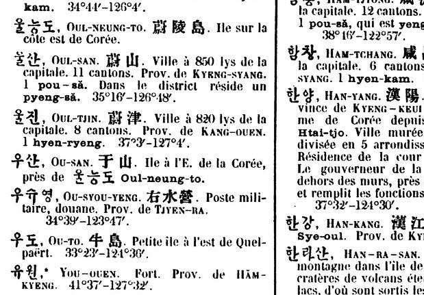
OUL-NEUNG-TO 蔚陵島 Ile sur la cote est de Coree
OU-SAN 于山 Ile a I'E . de la Coree, prés de Oul-neung-to.
(Ousan is Iland of Corea, next to (close distance) to Ulluengdo)
*Usually they dont say 90km distance is "prés de" but small distance (2km) do.

If they acknoledged the Usan is Takeshima(Liancourt Rocks) today, they would have written "It is Liancourt Rocks" on the dictionary. They doesnt consider "Ousan于山" is Liancourt Rocks.(French already recognized Liancourt Rocks around 1849 s by whale ship Liancourt and Frenc hydrographic office's Pilot magazine write Liancourt rocks on 1860's. )
1870.Carte de la Coree
Broughton bay:Goulf Broughton

1874. "Histoire de L'Eglise de Corée" by Claude Charles Dallet
http://dokdo-or-takeshima.blogspot.com/2008/05/1874-histoire-de-leglise-de-core-by.html
Mer du Japon
Detroit de Coree
Mer Jaune

P266(n277)
http://www.archive.org/stream/histoiredelegli00dallgoog#page/n277/mode/1up/search/japon
A L'embouchure du Mi-Kiang, pres de la mer du Japon, se trouve sur la frontiere de la Coree un boung tartare nomme Houng-tchoung, et chaque seconde annee, une foire considerable y reunit pendant quelques heures le peuple des deux pays limitrophes.
What? Korean claims "Sea of Japan" is colonialism name? Kidding. Korean is timetraveller? 1865-1890 Map of Corea also use Sea of Japan. Annexation of Korea is 1910.
http://dokdo-or-takeshima.blogspot.com/2008/07/c1865-french-map-of-korea-coree.html
cc: same design: R. Hausermann's Map of Korea (1880)
http://dokdo-or-takeshima.blogspot.com/2008/05/1880-r-hausermanns-map-of-korea.html
Mer Du Japon
Detroit De Coree
Mer Jaune

also, same design
d'apres la Carte du Dictionnaire coreen-francais per les Missionaires de Coree Echelle (1890)
http://oldbooks.co.kr/main.html?menu=view&uid=664&category=%C1%F6%B8%AE%C1%F6%C1%FA-%C1%F6%B5%B531 (Cache)
Mer Du Japon
Detroit de Coree
Mer Janue


I checked this map and I confirmed the existence of French-Corean dictionary.
Dictionnaire coréen-français par la Société des missions étrangères (1880)
http://www.archive.org/details/DictionnaireCoren-franais
http://www.archive.org/stream/DictionnaireCoren-franais/coreen_dictionnaire#page/n701/mode/2up
OUL-NEUNG-TO 蔚陵島 Ile sur la cote est de Coree
OU-SAN 于山 Ile a I'E . de la Coree, prés de Oul-neung-to.
(Ousan is Iland of Corea, next to (close distance) to Ulluengdo)
*Usually they dont say 90km distance is "prés de" but small distance (2km) do.
If they acknoledged the Usan is Takeshima(Liancourt Rocks) today, they would have written "It is Liancourt Rocks" on the dictionary. They doesnt consider "Ousan于山" is Liancourt Rocks.(French already recognized Liancourt Rocks around 1849 s by whale ship Liancourt and Frenc hydrographic office's Pilot magazine write Liancourt rocks on 1860's. )
1870.Carte de la Coree
Broughton bay:Goulf Broughton

1874. "Histoire de L'Eglise de Corée" by Claude Charles Dallet
http://dokdo-or-takeshima.blogspot.com/2008/05/1874-histoire-de-leglise-de-core-by.html
Mer du Japon
Detroit de Coree
Mer Jaune

P266(n277)
http://www.archive.org/stream/histoiredelegli00dallgoog#page/n277/mode/1up/search/japon
A L'embouchure du Mi-Kiang, pres de la mer du Japon, se trouve sur la frontiere de la Coree un boung tartare nomme Houng-tchoung, et chaque seconde annee, une foire considerable y reunit pendant quelques heures le peuple des deux pays limitrophes.
What? Korean claims "Sea of Japan" is colonialism name? Kidding. Korean is timetraveller? 1865-1890 Map of Corea also use Sea of Japan. Annexation of Korea is 1910.
7/14/2009
I need your help!
I want your help! But Im not beggaar so I dont ask you a donation or money. Just i want to know is the description of the Sea of Japan, Strait of Korea, Broughton bay(East Korean sea/Gulf), Yellow Sea on those books , and the attached maps , pilot guides, and charts (not "map")
But.I cant check the libraries overseas so please help if you can read those books below;
1860.Renseignements hydrographiques sur les îles Bashée, les îles Formose et Lou-Tchou, la Corée, la Mer du Japon, les îles du Japon (Ports d'Hakodaki, Ne-e-Gate, ... Yedo) et la Mer d'Okhotsk (French Edition) (Paperback) By Alexandre Le Gras
http://seaofjapan-noeastsea.blogspot.com/2010/11/1860-renseignements-hydrographiques-sur.html
1863 Chart #1467 Mer du Japon
France Navy
1867.Pilote de la mer de Chine, Ve Partie, La Mer du Japon.France Navy
Paris
1883. Observations upon the Korean Coast, Japanese-Korean ports and Siberia,: Made during a journey from the Asiatic Station to the United States through Siberia ... September 8, 1882 (Information from abroad)
Publisher: Govt. Print. Off
Benjamin H Buckingham
http://www.aaapricesearch.com/
1886.Recent Journeys in Korea
Proceedings of the Royal Geographical Society
W.H.Carles
http://www.oldbookbank.com
http://www.jstor.org/pss/1801318
1889.Detailed map of Dagelet by corvette Vitjaz1892.A Journey through North Korea to the Chang-Pai Shan
1895.Storm og Sogang
Richard Melander
http://www.oldbookbank.com/
1896.MATERIALI PER LA GEOGRAFIA della COREA
Tipografia Della R.Accademia del LINCEI,Roma
L.Nocennti
http://www.oldbookbank.com
1898.Nomi Geografici Coreani)
Lodovico Nocentini
http://www.oldbookbank.com
1904.Southern Manchuria and Korea
Royal Geographical Society,London
Robert T Turley
http://www.oldbookbank.com
http://www.jstor.org/pss/1775503
1904.Sailing Directions for Japan, Korea, and adjacent Seas.
LondonLangdon, C. H.
1918 .Asiatic Pilot Vol.1East Coast of Siberia,Sakhalin Island and Chosen.
1945.Guide to Geographical Names in Korea(Chosen)
1947 . Sailing Directions for The Southeast Coast of Siberia and Korea
https://sites.google.com/site/takeshimaliancourt/
But.I cant check the libraries overseas so please help if you can read those books below;
1860.Renseignements hydrographiques sur les îles Bashée, les îles Formose et Lou-Tchou, la Corée, la Mer du Japon, les îles du Japon (Ports d'Hakodaki, Ne-e-Gate, ... Yedo) et la Mer d'Okhotsk (French Edition) (Paperback) By Alexandre Le Gras
http://seaofjapan-noeastsea.blogspot.com/2010/11/1860-renseignements-hydrographiques-sur.html
1863 Chart #1467 Mer du Japon
France Navy
1867.Pilote de la mer de Chine, Ve Partie, La Mer du Japon.France Navy
Paris
Publisher: Govt. Print. Off
Benjamin H Buckingham
http://www.aaapricesearch.com/
1886.Recent Journeys in Korea
Proceedings of the Royal Geographical Society
W.H.Carles
http://www.oldbookbank.com
http://www.jstor.org/pss/1801318
1889.Detailed map of Dagelet by corvette Vitjaz1892.A Journey through North Korea to the Chang-Pai Shan
1895.Storm og Sogang
Richard Melander
http://www.oldbookbank.com/
1896.MATERIALI PER LA GEOGRAFIA della COREA
Tipografia Della R.Accademia del LINCEI,Roma
L.Nocennti
http://www.oldbookbank.com
1898.Nomi Geografici Coreani)
Lodovico Nocentini
http://www.oldbookbank.com
1904.Southern Manchuria and Korea
Royal Geographical Society,London
Robert T Turley
http://www.oldbookbank.com
http://www.jstor.org/pss/1775503
1904.Sailing Directions for Japan, Korea, and adjacent Seas.
LondonLangdon, C. H.
1918 .Asiatic Pilot Vol.1East Coast of Siberia,Sakhalin Island and Chosen.
1945.Guide to Geographical Names in Korea(Chosen)
1947 . Sailing Directions for The Southeast Coast of Siberia and Korea
https://sites.google.com/site/takeshimaliancourt/
6/13/2009
1736.Royaulme de Coree. Dh halde.
Description géographique, historique, chronologique, politique, et physique de l'empire de la Chine et de la Tartarie chinoise, enrichie des cartes générales et particulieres de ces pays, de la carte générale et des cartes particulieres du Thibet, & de la Corée; & ornée d'un grand nombre de figures & de vignettes gravées en tailledouce (1736)
Although D'anville's Carte de Royaulme de Coree describes "Mer du Coree" on east coast of Corean Peninsula, they use "Mer Du Japon(Sea of Japan) on the artiles.Volume Ⅳ Royaulme de Coree
PDF P170 http://www.archive.org/details/descriptiongog04duha
Après avoir fait ces 8o. lys à l'Eft, nous trouvâmes que la valée s'élargiflbit
confidérablement, 6c qu'elle formoit une plaine de plus d'une lieue
de diamètre. Nous traversâmes cette plaine en tournant vers leNord-Oueil,
6c nous pafsâmes la rivière : nous vîmes fur fes bords quantité de grofles pièces
de bois propres à bâtir, la plupart defapin: on les fait defcendre fur
cette rivière dans le tems qu'elle eft le plus fournie d'eau jufques vers la mer
du Japon: puis on les tranfporte dans une autre rivière, & en les faifant
floteriur l'eau, on les conduit jufqu'à une journée de Peking. C'eif ce qui
fait que le bois à bâtir n'y eft pas cher, quoiqu'il s'en fifle une grofle confommation
, parceque les charpentes des maifons font extrêmement fournies.
PDF 538
A Corée , qu'on peut appeller avec raifon la Cherfonefe de la Chine , puifqu'elle lui efi: contigue & triburaire, eftune grande peninfule qui s'avance en forme de cap dans la Mer orientale, entre la Chine & le Japon. La Mer du Japon la baigne à l'Orient ; le Golphe de Leao tong la fépare des Provinces de Pé tche li & de Chan tong du côté de l'Occident. Au Nord elle confine avec le pays
deNiutche (a) : elle a la grande Mer au Midi; & le fleuve Ta lou, qui la borne entre l'Occidentl & le Nord, & la diflingue du Leao tong. Elle a I200. lys {h) d'étendue d'Orient en Occident, & deux-mille-deuxà trois-cens lys du Septentrion au Midi.
La Corée a été autrefois la demeure de différens peuples , dont les principaux étoient les Mé , les Kao kiuli , les Han , & ces derniers fe partageoient encore en trois efpeces : fçavoir les Ma han , les Pien han , ..................
1/11/2009
1882.Un Touriste Dans L'extreme Orient
Un Touriste Dans L'extreme Orient 1882
Japon, Chine, Indo-chine et Tonkin (4 Aout 1881-24 Jannier 1882)
Edmondo Cotteau
(PDF P6)
Le 6 aout, nous apercevons a tribord la cote de Coree, sous la forme de haules collines ideues, trop eloignees pour qu'on puisse en distinguer les details.Nous passons beaucoup plus pres, a habord, de la petite ile Dagelet. Il y a quelques annees, un bateau danois y fit naufrage; son equipage pat se refngier sur L'ile Argonaute, indiquee dans ces parages par les anciennes cartes anglaises, n'existe pas
1/05/2009
1787.Jean François de Galaup, comte de La Pérouse first survey at Detroit de Coree and Dagelet,
日本海北西部朝鮮沿岸や、北東部Tataristanの地理情報は、世界航海が盛んになり始めても、1780年代になっても結局残されたままだった。La Perouseが日本海Mer Du Japon海域を探検し、朝鮮海峡Detroit de Coreeを測量し、これらの情報は、朝鮮半島東沿岸部を探検測量した英国のBroughtonや、ロシアのKrusesternなど"日本海”の探検家へと引き継がれる。これが契機で1730-1770年頃まで一時的に増えていた朝鮮海の記載が急減する一方で、朝鮮海峡の名称が新たに登場し、更に日本海が圧倒的多数に成ったのである。また、この後Broughtonの朝鮮東海岸の測量によってフランスなどの地圖にはBroughton Bayの附近にMer Du Coree(後のBroughton Bay, 現在のEast Korean Gulf)が記載される事となる。
日本海・朝鮮海峡関連で、シーボルトは以下のように記述している。
・25日夜間、わが艦は朝鮮の海峡を通過した。日没直後に、日本の海岸が東四分の一北東から東南東にかけて広がり、朝鮮の海岸が北西から北にかけて広がるさまを認めた。海は北東の方角に大きく広がっていくように見えたが、この方角からかなり大きなうねりが来ることがわかり、やはり海はこの方向に広がるのであると確認できた。
南西から疾風、夜は非常に明るかった。追い風を受けて航行、出来る限り縮帆して時速三分の二リユまでしか出ないようにした。太陽が昇り始めたらすぐに、前日夕刻の測量地点を確認し、朝鮮の海峡の正確な海図を引くためであった。私達の測量はすべてダジュレ氏に委ねられていたが、それに基づいて作成される海図の正確さについては、文句のつけようのないものであった。三十分ごとに水深測量を繰り返していて、辿っていくには朝鮮半島沿岸部のほうが、日本沿岸よりも興味深いように思われたので、朝鮮側から二リユの距離まで近づき、陸地の進む方向に平行して航行することとした。
Refernced from ;La Perouse 太平洋周航記 下 佐藤淳二訳 第十五章 カビナテ出航、台湾・朝鮮海峡から日本海へ
・能登岬の測定によってラ・ペルーズは、この海域の水路測量のために大きな貢献をしたのである。なぜなら、朝鮮や沿海州沿岸との関係における日本の位置 は、これによってかなり画定されることになったからである。彼らは次のように言っている。「大多数の読者にとって、まさに不毛と思われるこの短い鑑札のた めに、我々は濃霧おなかでの困難な十日間の航海を要したのだった。地理学者たちは、われわれがこの時間をよく利用したと考えるだろうが、ただわれわれの広 大な計画が、この沿岸、ことにこの国と朝鮮とを判っている海峡の芯の形を記述するtことが出来たと思われる南へ見勝手いくつかの地点を、調査士かつ測定す ることが許されなったことを遺憾におもうであろう。」、
Refernced from ;Philip von Sebold ”Japan" Vol1 第四章 ヨーロッパ人による日本とその海域発見の歴史的概観 P81
竹島問題関連
"...May 27th I gave the signal that we arrived on the East Sea. After a short while, to the North~Northeast an island was observed that was not on any charts. This island seemed to be 20 leagues (actual 137kms) away from the Chosun coast. I tried to approach the island but it was difficult because the island was is the same direction as the winds. Fortunately, during the night the direction of the wind had changed. (May 28th) By dawn we left toward the island for measurements and I decided to name this island Dagelet after the astronomer Lapaute Dagelet among our crew who sighted it first. The circumference of the island is only three leagues (actual 33kms) Maintaining a distance of 1.9kms from the island we travelled almost all around but failed to find deep water. Therefore I decided to lower a small boat into the water and left Boutin in command to check the depths of water en route to land. He soon found that the depth of this place was 140 meters and it was about 200 meters from the island. The Northeast point of the island is 37° 25' North latitude and the 129° 2' East longitude. Even though the island is made of sheer cliffs, from the top to the shore it is covered with very beautiful trees. Other that seven little inlets for mooring the island is surrounded by precipitous cliffs. In this little inlet we observed some boats of Chinese style being built. It appeared that those boat builders were startled by our ship maybe because they were within the range of our cannons. They fled into the woods about 50 paces from their workplace. However, what we saw was a few huts, with no village or crops. It appeared that some Chosun carpenters from the mainland which is only 110 kms from Dagelet come with provisions and build boats during the summer before they take them to the mainland for sale. I'm sure this assumption is correct. When we returned to the West point of the island we again observed other workers building boats but they didn't see us approach because a point of land blocked their view. Those people by a tree stump looked frightened to see us except for a couple of them who didn't seemed to be afraid of us, they all ran into the woods. I thought we needed to persuade them that we are good people and are not their enemy so I looked for a place to drop anchor. Unfortunately the strong currents pushed us away from the island. Night approached. Due to our concerns that we might again be pushed from the island, and fears of not being able to retrieve the dispatched boat under Boutin's command I signalled to M. Boutin, who was about to land, and ordered him to return. I ordered the Astrolobe which was far to the West due to currents, to approach Mr Boutin's group. Luckily the high peaks of Dagelet blocked the winds and spend the night peacefully...."
・27日、船首を風下の東に向けるよう合図したが、まもなく北北西に海図にない島を認めた。朝鮮半島から約20リユくらい沖合いであった。島に接近しようと試みたが、島へと風が吹つけていたので接近は無理だった。しかし夜のうちに風向きも変わり、空が白む頃にはこの島を偵察するべく船首を向けた。この島を最初に発見した天文学者であるダジュレ氏にちなんで、ダジュレ島と命名した。島は周囲僅かに三リユ、海岸線に沿って進み、ほとんど一周したが、三分の一リユまでせっきんしても海底を測深できなかった。そこでボートを降ろし岸辺まで測深させることを決断、ボートの指揮をブタン氏にとらせた。彼の報告では、海岸に打ち寄せるうねりが始まるあたり、島の岸から100トワーズの距離でやっと20ブラスの水深を測ることができたという。島の北東端は、緯度三十七度二十五分、パリ子午線緯度百二十九度二分であった。島は、一周三リユほどであろうか、切り立った海岸であったが、頂上から海面附近まで眼も覚めるような美しい樹木で覆われていた。剥き出しの岩壁が、殆ど城壁のように垂直に 立して島をぐるりと取り巻いていたが、例外として七箇所の砂浜の小さな入り江があり、そこは上陸可能であった。この入り江にみつけた作業場には、中国船とまったく同一の形状の船がいくつか建造中であった。艦載砲の射程距離内に私達の艦艇が現れるや、職人達は仰天したのか、作業場から五十歩と離れていない森の茂みの中に逃げ込んでいった。それとは別に、小屋がいくつか見受けられはしたものの、集落も耕作地も無かった。つまり、一番ありえそうな推論は、次のようになる。即ち、二十リユばかりしか離れていない朝鮮半島から船大工たちが渡ってきて、ここで作った船を朝鮮各地で売るのだろう、と。これは最初は憶測だったが、しかし次第に確信に変わっていった。というのは、西側の岬を回りこんだ際に、ここにもさらに作業場があって、それまで岬に隠れて見えなかったわが艦艇が突然姿を現したものだから、浜の職人たちがびっくりして森に転がるように逃げていくのを目撃したらだった。私たちを見ても平然として後に残っていたのは、せいぜい二、三人であった。停泊できる場所を見つけて友好の態度を示し、是非とも私たちが敵でないことを納得させたかったのだが、しかし激しい潮流によって船は岸から引き離されたのだった。周囲は夜の帳が下りようとしていたので、ボートに帰還を命じざるを得なかった。ブタン氏は上陸目前であったが、船が風下に流されてボートが改修できなくなる事を私は強く懸念したからである。潮流にながされてずっと西にまで進んでいたアストロラブ号にようやく追いつく頃には、凪の静かな夜となった。ダジュレ島にXえる山々が、沖合いからの突風を遮ってくれるおかげだった。
Refernced from ;La Perouse 太平洋周航記 下 佐藤淳二訳 第十五章 カビナテ出航、台湾・朝鮮海峡から日本海へ
・不成功に終わった彼の航海の第三年目に当たる一七八七年六月六日、能登国の幅広い半島の一部をなす本州の西北の海岸をかすめて通った。これは19世紀のはじめまでヨーロッパ人の航海者が訪れた日本の北西の端の唯一の地点である。
そこへ向かう途上彼は、日本人には既に以前から知られていた小島、松島Matsushimaを発見し、これをダジュレーDageletと名づけた。
Refernced from ;Philip von Sebold ”Japan" Vol1 第四章 ヨーロッパ人による日本とその海域発見の歴史的概観 P80-81
Cf:
・Chart by La Perouse
Mers, Chine, Tartarie. La Perouse, Jean-Francois de Galaup, comte de, 1741-1788, 1797
Plan de Eile Dagelet 鬱陵島

・Maps by Sebold collection .(requires Djvu Installation)
12/30/2008
D'anville Royaulme De Coree and Qing dynasty's 皇輿全覧圖
After the publication of D'anville's Map, Corea(Korea) become clealy recognized in Europe.
On 1707, Qing-dinasty Emperror "康熙帝" ordered to the missionary of Societas Iesu to produce map ,which based on the information by Surveying.
Tartary's officer brought from Corea to China that Map of Corea which it was stored on palace of Corea . (Du halde "China" Page 530 line 7)
On 1717 Map had completed and named 皇輿全覧図. D'anville's map of "Royaume de Coree"D'anville is the French translated version of 皇輿全覧図.
1735 - Pere J. B. Du Halde with maps by d'Anville, "Description Geographique, Historique, Chronologique, Politique, et Physique de l’Empire de la Chine et de la Tartarie Chinoise" was publised in The Hague. The Korean map was illustrated in the book.
1737 - "Royaume de Coree, Nouvel Atlas de la Chine" by d'Anville
1927.満漢合璧清内府一統輿地秘図ーーDiscovered on 1927 ,. This map is said that one of the original copy of 皇輿全覧図 published on 1717.

Jean Baptiste Bourguignon d'Anville (1697-1782), perhaps the greatest geographical author of the 18th century, was born at Paris on the 11th of July 1697. Both a geographer and cartographer, he greatly improved the standards of map-making. His maps of ancient geography, characterized by careful, accurate work and based largely on original research, are especially valuable. He left unknown areas of continents blank and noted doubtful information as such; compared to the lavish maps of his predecessors, his maps looked empty.
12/21/2008
Mer Du Coree is Broughton Bay, Not the area of Sea Of Japan.
Briefly intrudoction of the changing process what was Mer Du Coree, today's brougton bay and how "Sea of Japan" has spread around the grobe.
1602. 坤輿万国全図-Oldest map discribes Sea of Japan has published by Mateo Ricci
1730-1770 c.a There are the Map discribes both Sea of Japan and Korean sea at the location of Sea of Japan. Koraen sea is newly recognized from the influenced by Danville's Map, referenced from Chinese map .
But , the name of Korean sea is not established difiniation ., one discribes at Broughton bay, one at just a east coast of Korean peninsula, one at sea of Japan,
1784. La Perouse's discovery navigation promotes Mer Du Japon at the the Sea of Japan area today, and promotes Detroit de Coree at the Korea strait today. at the same time, Mer de Coree also spread at the Broughton Bay, today's East Korean gulf.
1824. Krusestern's "Pacific sea chart Collection" spread "Sea of Japan" more. he dinied Korean Sea is not the area of Sea of Japan and he recognized Korean sea is just a part of east coastal area of Korean peninsula. Also Mer du Coree has discribes Brougton bay or Brouhghton Gulf around this era.
1850-60 These maps around this era, Maps has updated to published ,referenced from Krusestern's information. also The map by Matthew Perry, squardon of U.S navy to Japan, his map also discribes "Sea of Japan.
Also, U.K Hydro office's publication, e.g. China pilot and China sea dictionary discribes Sea of Japan and it is spread around the grobe. Also, Mer du Koree is spread, established recognization of Broughton bay ,Gulf of Korea.
So, that is to say, It is completely distorted claims by Korean from 1990's that the name of "Sea of Japan" is colonial and expansionism name and heritages. Those distorted Korean theory is just a political-oriented negative campaign toward Japan for money.
So, Let's gotta check various maps by yourself" especially the name of Sea of Japan, Broughton bay and Korea strait!
1646. ASIA CARTA DI CIASETE PIU MODERNA by R.Dudley
East coastal area of Chosun(Korean) peninsula discribed as Mer de corai
Sea of Japan area discribes as Oceano Boriane Del Gappone

1738.Isaac Tirion: Nouvelle carte de l'Empire de la Chine.
East of Chosun(Korean)Peninsula:Mer Du Coree
Between Busan and Tsushima islet:Detroit de Coree
Between Japan's Honsyu and Tartary :Mer du Japon


Around 1730's ,when Royaulme de Coree by D'anvillehad published, Mer de Coree name had temporary increasing.
One of the example:1749. Le Japon, by G.Robert de Vaugondy , 1749
East coast of Chosun(Korean) Peninsula, Mer De Coree


Left:1750. .L'Empire du Japon. Robert de Vaugondy, Gilles, 1688-1766 ; Robert de Vaugondy, Didier, 1723-1786, 1750
Right:1776-84.L'Empire Du Japon Divise En Sept Principales Parties
East coast part of Korean peninsula discribes Mer De Coree.
Sea of Japan parts discribes Mer De Japon.


1784(1792)Carte De L'Empire De La Chine Tardieu Paris 1832
Around Broughton bay part, it discribes Mer De Coree.
Between Busan and Tsushima parts discribes Strait of Coree.
Sea of Japan parts discribes Mer De Japon.


1787のMers, Chine, Tartarie. 2. by La Perouse, Jean-Francois de Galaup, comte de, 1741-1788 from 1797
Around Broughton bay part, it discribes nothing.
Between Busan and Tsushima parts discribes Korea strait.
Sea of Japan parts discribes Sea of Japan.
1790.Allowsmith Chart of the world on Mercator's projection, exhibiting all the new discoveries to the present time: with the tracks of the most distinguished navigators since the year 1700, carefully collected from the best charts, maps, voyages, &c extant. And regulate
Around Broughton bay part, it discribes Gulf Of Korea.
Between Busan and Tsushima parts discribes Strait of Korea.
Sea of Japan parts discribes nothing.
1803.Edme Mentelle. Pierre-Gregoire Chanlaire Carte de l'Empire de la Chine.Paris,
Around Broughton bay part, it discribes Mer De Coree.
Between Busan and Tsushima parts discribes Strait of Coree.
Sea of Japan parts discribes Mer De Japon.

After the discovery navigation by Krusenstern, North East part of Korean peninsula parts has been discribed as Broughton Bay. Bronghton Bay is increasing instead of Mer de Coree.
1824 Kapta poluostrova Koreia (Map of Korea by Krusenstern)
1826 Karta poluostrova Koreia. 1826 http://international.loc.gov/cgi-bin/map_item.pl
Around Broughton bay part, it discribes залива Bpoyroha(Brougton Gulf).
Between Busan and Tsushima parts discribes пролив Корейский(Korea Strait)
On the other hand , Wide map incruding Japan,China, Korea he discribes;
round Broughton bay part, it discribes залива Bpoyroha(Brougton Gulf)
Sea of Japan parts discribes море Японское (Sea of Japan)
1833 Das Chinesische reich mit seizen schutzstaaten nebst dem Japanischen Iselreiche Justus Perthes 1833
1843. Carte von China und Japan den Manen d’Anville’s und Klapproth’s. Posrdam
Around Broughton bay part, it discribes Bay von broughton.
Between Busan and Tsushima parts discribes Korea strait.
Sea of Japan parts discribes Japanech Meer
1840. Sebold "Japan" 19 -20 Map of Chosun(Korea) by Japan's records.
Korean map discribes Broughton bay in the location of Broughotn bay.
1832.日本辺界略図 シーボルト『日本』収録 (1809.P42 第一分冊 幕府天文方 高橋景保1809)
1854.『日本界国へ向けての蘭・露の努力』日本辺海略図 Sebold at Bonn
Between Busan and Tsushima parts discribes Channel of Korai.
Sea of Japan parts discribes Japanische sea.
1843. China. Arrowsmith, John, 1844
1843Copperplate engraving from the National Atlas of Geography published 1843 by Alexander Keith Johnston (1804 - 1871): Map of China with an inset of Canton
1844.William Johnston; Alexander Keith Johnston: China
1849. An outline chart, for the purpose of marking off the track of a ship. Blachford & Imray. London.
1850. China and Japan,Milner's Descriptive Atlas, 1850
1851TALLIS, John.Japan & Corea London, John Tallis & Co., 1851. 265 c 330.
1851. J. Rapkin: Japan and Corea.
Around Broughton bay part, it discribes Broughton Bay.Between Busan and Tsushima parts discribes Strait of Korea.
Sea of Japan parts discribes Sea of Japan.
1855.-2 :JAPAN NIPON,KIUSIU & SIKOK and the part of KOREA
ACCORDING TO KRUSENSTERN'S CHART OF 1827
Around Broughton bay part, it discribes Broughton Bay.
Between Busan and Tsushima parts discribes Strait of Korea・Korean channel.
Sea of Japan parts discribes Sea of Japan.
Around 1850-60, Broughton Bay,Gulf Of Corea was established, before it is discribes only "Broughton Bay" or Mer de Coree" It seems the effect by the Mattew Perry Map and U.K Hydro office's China pilot and China Sea dictionary. Ofcourse "Sea of Japan" had already been recognized as estalbished name.
1856. 1Map of
Around Broughton bay part, it discribes Broughton Bay Gulf of Corea.
Between Busan and Tsushima parts discribes Strait of Korea・Korean channel.
Sea of Japan parts discribes Sea of Japan.
1860. China and Japan Johnston Edinburgh / 1861
1861. China, Japan. by Johnston, Alexander Keith, 1804-1871 from 1861
Around Broughton bay part, it discribes Broughton Bay Gulf of Korea.
Between Busan and Tsushima parts discribes Channel of Korea.
Sea of Japan parts discribes Sea of Japan.

1863-2U.K hydro office:JAPAN NIPON,KIUSIU & SIKOK and the part of KOREA
1863.U.K Hydro office Japan and Korea 日本・朝鮮図
Around Broughton bay part, it discribes Broughton Bay Gulf of Korea.
Between Busan and Tsushima parts discribes Channel of Korea.
Sea of Japan parts discribes nothing.
1864. J.Bartholomew Japan Manchuria, Chishima. Edinburgh, [1864]
Around Broughton bay part, it discribes Mer De Coree..
Between Busan and Tsushima parts discribes Strait of Coree.
Sea of Japan parts discribes Mer De Japon.


1865.Adrien-Hubert Brue Carte general de l'Empire Chinois et du Japon
Around Broughton bay part, it discribes Mer De Coree..
Between Busan and Tsushima parts discribes Detroit de Coree.
Sea of Japan parts discribes Mer De Japon.


1870.August Petermann.China(Ostr. Theil).Korea und Japan.
Around Broughton bay part, it discribes Broughton B.Gulf v Korea.
Between Busan and Tsushima parts discribes Korea Strass.
Sea of Japan parts discribes Japanisches Meer.


1873 U.K Hydrographic Office
Preliminary Chart of
Around Broughton bay part, it discribes B.Broughton or .Gulf of Korea.
Between Busan and Tsushima parts discribes Korea Strait.
Sea of Japan parts nothing discribed especially.


1874. J. Migeon Chine et Coree.
Around Broughton bay part, it discribes B.Broughton or .G de Coree.
Between Busan and Tsushima parts discribes Korea Strasse.
Sea of Japan parts discribed as Mer De Japon.


1875.
Around Broughton bay part, it discribes Broughton B oder Gulf of Korea.
Between Busan and Tsushima parts discribes Korean Strasse, Broughotn Strasse.
Sea of Japan parts discribed as Japanisches Meer.


1880 Map of
Around Broughton bay part, it discribes Broughton B.Gulf v Korea.
Between Busan and Tsushima parts discribes Korean Strasse.Sea of Japan parts discribed as Japanisches Meer.


1880.Map of
Around Broughton bay part, it discribes Korean Gulf.
Between Busan and Tsushima parts discribes Korean Strasse.Sea of Japan parts discribed as Japan Sea.


1888 bartholomew map British map of Japan and Corea
Around Broughton bay part, it discribes Broughton B or G of Borea(mispelled fromCorea?).
Between Busan and Tsushima parts discribes Corea Strait.Sea of Japan parts discribed as Sea of Japan.


1888 bartholomew map British map of Japan and Corea
Around Broughton bay part, it discribes Broughton Bay or Gulf of Korea.
Between Busan and Tsushima parts discribes Korea Strait.Sea of Japan parts discribed as Japan Sea.


1894 (1897) German map of
Around Broughton bay part, it discribes Broughton Bai or Gulf v Korea.
Between Busan and Tsushima parts discribes Korea STR.Sea of Japan parts discribed as Japanische Meer


1897.Bacon’s Popular atlas of the world map; Japan
Around Broughton bay part, it discribes Broughton Bay or Gulf of Korea.
Between Busan and Tsushima parts discribes Korean strait.
Sea of Japan parts discribed as Japan Sea.1898.Bangkokzenzu(Japan)
Around Broughton bay part, it discribes ブルートン朝鮮海'Broughton/Chosun Sea).
Between Busan and Tsushima parts discribes Korean strait朝鮮海峡.Sea of Japan parts discribed as Japan Sea日本海.

1899 Map of
Around Broughton bay part, it discribes Korean Gulf.
Between Busan and Tsushima parts discribes Korean strait.
Sea of Japan parts discribed as Sea of Japan.


1900.The Times Map: Map of China(East) and Korea
Around Broughton bay part, it discribes Broughton Bay .
Between Busan and Tsushima parts discribes Korean strait.
Sea of Japan parts discribed as Sea of Japan


1904
Around Broughton bay part, it discribes Broughton Bay or Gulf of Korea.
Between Busan and Tsushima parts discribes Korean strait.
Sea of Japan parts discribed as Japan Sea.


1904..Russo-Japanese War District Cram, George F Chicago George F. Cram, 1904.
Around Broughton bay part, it discribes Broughton Bay or Gulf of Korea.
Between Busan and Tsushima parts discribes Korean strait.
Sea of Japan parts discribed as Sea of Japan.


1904.
Around Broughton bay part, it discribes Broughton Bay or Gulf of Korea.
Between Busan and Tsushima parts discribes Korea strait.
Sea of Japan parts discribed as Sea of Japan日本海.


1907.韓国総攬 韓国全図(Full Map of Korea)
Around Broughton bay part, it discribes East Chosun Gulf東朝鮮湾
Between Busan and Tsushima parts discribes Strait of Korea朝鮮海峡.
Sea of Japan parts discribed as Sea of Japan日本海

1910.c.a. Map of Corea
Around Broughton bay part, it discribes .
Between Busan and Tsushima parts discribes .
Sea of Japan parts discribed as


登録:
コメント (Atom)


