11/03/2010

1870.輿地誌略 巻一 大學南校 内田, 正雄

1870.輿地誌略 巻一 大學南校 内田, 正雄
http://ir.u-gakugei.ac.jp/handle/2309/106847

Attached map
http://ir.u-gakugei.ac.jp/images/00382341/kmview.html 

map of Asia(P64): 日本海(Sea of Japan) and 東海(East(China)Sea)and 黄海Yellow Sea


map of Japan (P68);日本海(Sea of Japan) and 朝鮮峡(Strait of Korea)


Text:
http://klibredb.lib.kanagawa-u.ac.jp/dspace/handle/10487/4548
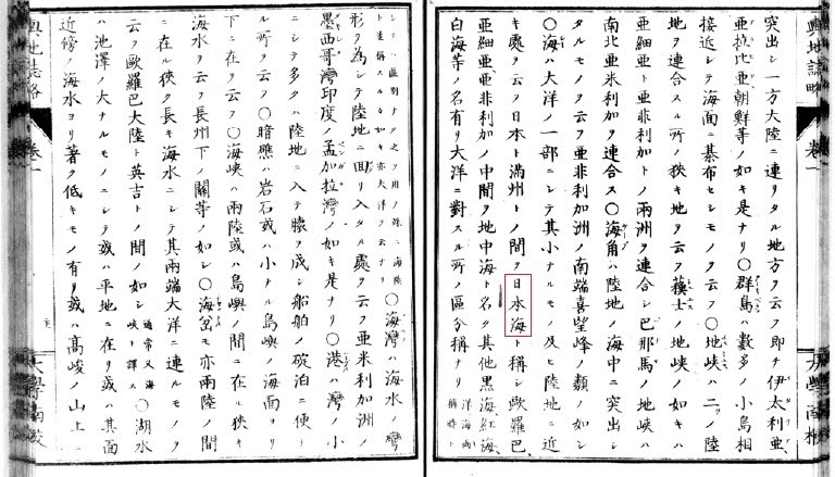
巻1 亜細亜
○海(シー)は太陽の一部にして其小なるもの及ひ陸地に近き処を云ふ日本と満州との間を日本海と称し、
Sea" is the part of "Ocean" and small one, nearby the land. The sea between Japan and manchuria called Sea of Japan.
http://klibredb.lib.kanagawa-u.ac.jp/dspace/bitstream/10487/4548/3/%E8%BC%BF%E5%9C%B0%E8%AA%8C%E7%95%A5%E3%80%80%E5%B7%BB%E4%B9%8B%E4%B8%80%E3%80%802.pdf

11/02/2010

1878.La Chine et le Japon et l'Exposition de 1878

1878.La Chine et le Japon et l'Exposition de 1878
http://www.archive.org/details/lachineetlejapo00fontgoog
Author: Clovis Lamarre , Adalbert Frout de Fontpertuis
Publisher: Librairie Ch. Delagrave

Attached Map
http://www.archive.org/stream/lachineetlejapo00fontgoog#page/n74/mode/1up
Sea of Japan:Mer du Japon


*This image has folded map on digital archives.If you know the full images please advice us.

1832.TROIS ROYAUMES by Klaploth 

1832 Klaploth's  San kokf tsou ran to sets: ou Aperçu général des trois royaumes (Translated of San Kokf Tuuran Tsu Setsu (三国通覧図説:Original arthor:Hayashi Shihei林子平)
Author: Julius von Klaproth , Rinsifée
Publisher: Printed for the Oriental translation fund of Great Britain and Ireland, sold by J . Murray [etc., London]
http://www.archive.org/details/sankokftsourant00rinsgoog


There describes;
Sea of Japan: mer du Japon
Yellow Sea: mer Jaune


P12 reference;
(3)Ced deux fleuves sont le Ya lou kiang, qui se jette dans la
mer Jaune et le Tommen outta, qui a son enbouchure dans la
mer ju Japon. Co dernuer porte dans les relatius japonaises le
nom de Foro-ara, il a d


P103 reference (about Takeshima Dagelet Ulluengdo)


P103-104
34. L'ile Thian sian tao,ou des Immortels
du Ciel, est dans la mer au sud de Thsiuan
tcheou. On L'appelle aussi Lan chan tao.

35.Tchu tao, ou l ile du Bambou, est au
sud-ouest de la frontiere de Khing tcheou,pres
de la cote. Sous les Ming, dans la vingt-
cinquieme des annees Wan ly (1597), les Japo-
nais,ayant etabli leur station maritime a Fou
chan, faisaient des descentes frequentes sur cette
ile, d'ou ils inquieterent Liang chan et Hioung
tchhouan. Bientot apres ils s'emparerent de
Liang chan et entrerent dans Khing tcheou (i)
L'ile Kiu tsi tao est a l'est de celle de Tchu
tao, pres de la cote. Les Tchao sian y ont etabli
la ville de Kiu tsi hian, ainsi qu'un port pour
leur marine militaire. Elle est dans une assiette
plus forte que celle da Fou chan.

references;
(1)Cette ile 島竹 Tchu tao, ou de Bambou, ne peut
etre la meme qui est representee sur la Carte du Tchao sian, ac-
compagnant ce volume. Celle-ci Ri'est pas situee au sud-onest de la
ville Khing tceou et pres de la cote , mais au nord-est, et a
une distance considerable de la cote de la Coree. Elle est ap-
pelee par les Japonais Take sima (ce qui signifie egalement Ille de
jBambou ), et porte aussi les noms de 國山于 Thsian
chan koue (ou d'apres la prononciation japonaise Sen san kokf)
Royaume de mille Montagnes, et 島陵鬱 Yu Ling tao
Wots rio too) Elle est habitee moitie par des Coreens moitie
par des Japonais. Il parait que c'est V Ille de Dagelet decouverte
par La Perouse. Kt.

*Rmks; Ulluengdo used to be called as Takeshima in Japan on Edo-era. This "Takeshima" is different from Today'S "Takeshima" of Lianocourt Rocks"

Attached map;

Carte de la Coree

Carte TROYS ROYAUMES

CF; Map of Kanwondo (Joseon dynasty). It is said that Hayashi shihei draw Ulleungdo(Takesima in edo era, not liancourt rocks) referenced from the Korean atlas stored at Nagasaki. The unnamed adjuctive island ,northeast of Take-sima on Carte Troys Royaume,
is same match with the Korean atlas below. It is Usando-Boussoule Rock.


https://sites.google.com/site/takeshimaliancourt/hayashi-shihei-tuto-shiboruto-zu-nikansuru-kojin-teki-na-kousatsu

1902.Corean Words and Phrases ,John W. Hodge

Corean Words and Phrases: Being a Handbook and Pocket Dictionary for Visitors to Corea (1902)
Author: John W. Hodge
Publisher: Seoul press
http://www.archive.org/details/coreanwordsandp00hodggoog


Sea of Japan:
Sea of Japan
Yellow Sea :Yellow Sea

Page 265 (n285) river
http://www.archive.org/stream/coreanwordsandp00hodggoog#page/n285/mode/1up/search/japan

River, A Kang X (Some of the chief rivers in Corean: In the north, Am-nock-kang XXX, emptying itself into the Yellow Sea ; To-man-kang XXX, emptying itself into the Sea of Japan. On the West Coast: Tchung-fchuu-kang XXX;lTai-tong-kang XXX; Han-kang XX; Chang-pbau-kang XXX; Keum-kang XX; Yong-san-kang XXX. On the south coast : Ack-yang-kang XXX, Nuk-tong-kang XXX

1897.The Corean government: constitutional changes, July 1894 to October 1895.

The Corean government: constitutional changes, July 1894 to October 1895. With an appendix on subsequent enactments to 30th June 1896 (1897) Wilkinson, William Henry, 1858-
http://www.archive.org/details/cu31924023425063

**I couldnt find any name of the sea on this book.


Attached map (Dagelt island incrude, Liancourt rocks no incrudes)
http://www.archive.org/stream/cu31924023425063#page/n19/mode/2up


Dagelet Island.
http://www.archive.org/stream/cu31924023425063#page/n143/mode/2up/search/Dagelet

APPENDIX Ⅱ 
PRINCIPAL MEMORIALS APPROVED BY THE KING,
14th of October 1894 to 4th October 1895.

No.17 4October Dagelet Island: appontment of Overseer(To-kam).

11/01/2010

1904.Korea. by Hamilton, A. (Angus)

Korea (1904)http://www.archive.org/details/korea00hamigoog
Hamilton, A. (Angus), 1874-1913 New York, C. Scribner's sons
Year: 1904

Sea of Japan: Sea of Japan
Broughton bay: Broughton Bay
Yellow Sea: Yellow Sea

Chapter Ⅰ
SUPERSTITION AND BELIEFS
P7 (N61)
http://www.archive.org/stream/korea00hamigoog#page/n61/mode/1up/search/japan

Englishmen were not the sole navigators who were attracted by the unknown character  of the land, and the surpassing dangers of the waters, around the Island of Quelpart, wherre the Sea of Japan mingles in tempestu-ous chaos with the Yellow Sea. Russian and French navigators also worked their way throught the danger-ous shoals and quicksands, along the tortuous and muddy rivers, into the harbours and throught the narrow straits which hold back these islands from the main land. The shores teem with the distinguished name of men of science and sons of the high seas.  Following the curl and twist of its configuration a host of buried names are revealed, the last evidence of men who are dead and forgotten. It is infinitely patheric that even this one last resting-place should b e denied to their reputations. ,who shares Broughton's Bay; Unkoffsky, who foundered in the waters of the bay which is described by his name; the ill-fated La Perouse, who, in June, 1787, discovered in the Sea of Japan an island which now bears the name of the astronomer-Dagelet. Durock, Pelisier, Schwartz, and the rest- what echo do we find of them, their fates, and subsequent careerrs? Should not their names at least bear witness to their pains and labours, to the difficulties which they faced, to the small joy of something attempted something done, wich was their sole consolation for may hours of cheerless and empty vigil?

1895.Quaint Korea , by Miln, Louise Jordan

Quaint Korea (1895)
Author: Miln, Louise Jordan, 1864-1933
http://www.archive.org/details/quaintkorea00milnrich

Sea of Japan: Sea of Japan
Yellow Sea: Yellow Sea


Chapter Ⅲ SOUL FROM THE CITYWALL
http://www.archive.org/stream/quaintkorea00milnrich#page/34/mode/2up/search/japan

Korea is a most distressingly hilly country.
If you elect to go for a decent stroll,
it is a matter of climbing a hill,and
when you reach the summit of the hill
it is a matter of tumbling down the other side,
to scramble up another hill, and and downs,
even though you go north until you reach the
" Ever White Mountain," and, in reaching it,
reach the " River of the Duck's Green,"
which, flowing towards the south,divides Korea
from China; reach the Tu Man Rang which,
flowing towards the north-east, divides Korea
from the territory of the Tsar. Up and down
it will be, even though you push east
until you reach the purple " Sea of Japan."
Still up and down you will find it,
although you go as far south, or as far west,
as Korea goes, and find yourself
on the shores of China's " Yellow Sea."
Korea looks like a stage storm-at-sea.
Its hills are so many that they lose their grandeur,
as individuality is lost in multitude.