8/30/2011

Matsimaは松島か、松前か?

1760.東海呼称問題:18世紀の英辞典も「Sea of Corea」 の報道について、
の添付画像に書かれたMatsimaについて。

一部ブログなどは、きちんと検証もせずに、この記事の『Universal Gazetterに添付されている地図に書いてあるMatsimaを、江戸時代の日本の竹島の呼称である、”松島”である』との書き込みを見たことがありますが、これは正しくないです。結論からすると、これは松前と考えられます。

まず、例の報道1760年のUniversal Gazetterの写真を見てみます。
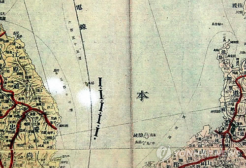
この写真の、北海道のような大きな島と、そしてその南、すなわち北海道と思われる島と本州の間にいくつか小さな島がある事に注目してください。
次に、1745年のBowenのアジア図を見てみます(David Ramsey)
この地図にはYedzoつまり北海道と思われる島と、本州の間に
島がいくつか記載されています。ここにMatsimaIと記載があります。
これが、1760年の地名辞典の添付図に記載されたMatsimaとほぼ一致します。
このことから考えると、作者は、松島ではなく、松前を意図して書いたものではないか、と推測します。
島根の竹島の江戸時代の名称"松島”を記載するとなると、隠岐の北西とか、そのあたりに記載すると考えられますし、また、鬱陵島、つまり江戸時代名”竹島”を記載せずに、”松島”だけ記載しているというのも妙な話です。


地図:1745.A new & accurate map of Asia. Drawn from actual surveys, and otherwise collected from journals; assisted by the most approved modern maps & charts. The whole being regulated by astronl. observations. By Eman. Bowen. (London: Printed for William Innys, Richard Ware, Aaron Ward, J. and P. Knapton, John Clarke, T. Longman and T. Shewell, Thomas Osborne, Henry Whitridge ... M.DCC.XLVII)
http://www.davidrumsey.com/luna/servlet/detail/RUMSEY~8~1~2580~270032:A-new-&-accurate-map-of-Asia--Drawn

この地図から判断すると、本州の北端と北海道の間にある二つの島の一つにMatsimaIと記載があります。これは、所謂江戸時代の松島(現在の島根の竹島)ではなく松前でしょう。
ひょっとすると、外国人は、長崎の出島のような、島だと思ったのでしょうか?北方探検史は詳しくないので詳しい方ご存知でしたら教えてください。

そして、決定的なのは、 A system of universal geography, or A description of all the parts of the world, on a new plan, according to the great natural divisions of the globe 1834 の記述です。
http://books.google.co.jp/books?id=iKUgAQAAMAAJ&pg=PA385&lpg=PA385&dq=MatsimaI&source=bl&ots=6DsqeZlgwY&sig=JXZdyTxNT0cqp28K-frDbMWkWIY&hl=ja&ei=UaldTteZMsSImQWUrY0B&sa=X&oi=book_result&ct=result&resnum=3&ved=0CCwQ6AEwAg#v=onepage&q=MatsimaI&f=false
ここに、Matsumae/MatsimaIが出てきます。
Matsumai*1, or the Town of the Strait")Matsi being the word for a strait、is built near the south end of tehe island. It is a Japanese fortress, and inaccessible by land. Other military post extend along the western coast all the way to the northern point. It consting the western shore, we meet with the islanns of Osima, Kosima, Okosiri, Rissiri, (which contains the Pic Je Langle of La Perouse) and Refoonsiri. Trhe large grlph which extends inthe the country, is called by the Russia the Gulph of Strogonof. The last station to the north is Notsjiab, the Notzamboo of Krusenstern . 以下省略
脚注
*MatsimaI

このMatsumaiについてはUniversal geography, or A description of all parts of the world, on a new plan, according to the great natural divisions of the globe.1827にも出てきます。

まあ、この地図にはSea of Koreaが記載されてはいます。そして、例のMatsimaIが記載されています。
先の報道ですと、画像はMatsimaとなっておりますが、位置、スペルから該当するとIが脱落または誤字によるものか、どちらかだと思います。

まあ、この時代の西洋の地図に竹島(鬱陵島)松島(島根竹島)が掲載されているとは思えません。西洋の地図で鬱陵島がきちんと記載されるのが、James Conett aboard Argonautの発見”Argonaut island"とLa Perouseの日本海探検のときのDagelet、これが1780年代です。この二つの記録が、西洋では欝陵島の”発見”の最初とされており、それ以前に欝陵島の報告はありませんし、これいこう、シーボルトに関しても、竹島をアルゴノート島、松島をDagelet島として、まあ実際には欝陵島の話しなのですが、日本のいわゆる江戸時代の松島は西洋に全く知られていません。
また、西洋においては、現在の島根の竹島はLiancourt rocksもしくはHornetRocksと呼ばれていましたが、この”発見”はフランス捕鯨船Liancourt号が1849年に”発見”したもので、それ以前から存在を知られていたとは考えられません。

ArgonautとDagelet以前は、D'anville系統の地図が特徴的ですが、朝鮮半島付近にはTchansantaoとFanglintaoの二つが、おもに朝鮮で製作された地図を載せた中国図に記載されますが、これらにはTakoshima/TakeshimaとMatsusimaの名称はありません

この成果をまとめた海図がKrusenstern以降、1850年代の英国海図以前の地図ですが、この時期の地図には旧来の中国図からTchansantaoとFanlintaoを朝鮮半島沿岸Sampu(さむちょく)付近に書き、一方ArgonautとDageletを日本海の洋上にも書いています。

そしてこのArgonautとDageletにTakoshima/TakeshimaとMatsusimaを宛がうのがシーボルトで、それによりこの二つの島(実際はアルゴノート島は存在しない)が西洋の地図に記載されることになります。


このような経緯で、竹島アルゴノート島と松島ダーシュレ島が西洋の地図に載るようになった経緯を時期を考えると、それ以前の時代に記載されたMatsimaが江戸時代の松島つまり島根竹島である可能性はまず考えられません。これは上述の欧米資料から考えると、松前であると考えられます。

8/29/2011

1896.Problems of the Far East, Japan--Korea--China

Problems of the Far East, Japan--Korea--China (1896)
Author: Curzon, George Nathaniel Curzon, Marquis of, 1859-1925
Publisher: Westminster : A. Constable and Co.
http://www.archive.org/details/problemsoffareas00curz

attached map of Korea: nothing name of marginal sea between japan and korea.
But Broughton Bay or Koraen gulf was written in east korean gulf today
http://www.archive.org/stream/problemsoffareas00curz#page/214/mode/1up

text:the Sea of Japan
http://www.archive.org/stream/problemsoffareas00curz#page/212/mode/2up/search/sea
In the negotiations that passed between the respective Governments it was obvious, indeed, that what China shrank from, and what Korea dreaded, was not the establishment of a British naval or coaling station, or even of a British maritime fortress in the mouth of the Sea of Japan, but the chance of a corresponding Russian movement in some neighbouring quarter; and both Powers were grateful for a step which forced th land of Rusia, and compelled her to give a guarantee, which lent a renewed lease of life to the phantom of Korean integrity , and has so far saved the little kingdom from sudden or surreptitious deglutition at the hands of her formidable neighbour.


Korean said "the name of Sea of Japan is spread after annexaton of Korea on 1910?" The name of sea of Japan already established as a international conventional words far before annexation.. 2003.02.13.Korean lies more 671 times than Japanese do. Ofcourse bloggers here already recognize Korean claims is filled up with distorture.

8/20/2011

1811.Reize om de wereld gedaan in de jaren 1803, 1804, 1805 en 1806 [microform] : op bevel van Alexander den eersten keizer van Rusland

Reize om de wereld gedaan in de jaren 1803, 1804, 1805 en 1806: op bevel van Alexander den eersten keizer van Rusland (1811)
Author: Kruzenshtern, Ivan Fedorovich, 1770-1846
Publisher: Te Haarlem : Bij A. Loosjes Pz.
http://www.archive.org/details/cihm_18433

Attached map:
Japaniche Zee (Japan Sea)
Stram van Corea (Strait of Corea)


http://www.archive.org/stream/cihm_18433#page/n6/mode/1up


8/17/2011

The Defenition of "Sea of Japan " is as follows on S-23

U.S. asks IHO if ‘East Sea’ could be in index
http://joongangdaily.joins.com/article/view.asp?aid=2940120
August 12, 2011
WASHINGTON - The United States government has asked the International Hydrographic Organization (IHO) to consider using East Sea as an “alternate name” for the Sea of Japan in the appendix of its internationally recognized publication, a diplomatic source told the JoongAng Ilbo on Tuesday.
The move came after the Korean public responded angrily to reports that a U.S. government agency informed the international authority of its support for the sole use of the Sea of Japan to refer to the body of water that lies east of the Korean Peninsula.
Koreans have called it the East Sea for the past 2,000 years, according to historical documents. Seoul has maintained that the IHO should use its preferred name together with the Sea of Japan.
The United States, the source said, told the IHO to consider possibly listing the East Sea as an alternate name in its appendix, as it would be difficult to use both names simultaneously in the main text of its authoritative publication on the names and locations of bodies of water.
“Including the East Sea in the appendix can show that it is being used as another name for the Sea of Japan,” the diplomatic source said.
By Park Seung-hee [joe@joongang.co.kr]


I guess the proposal is ,to using Sea of Japan in chart, and to add the text " Korean call it "East Sea"? on the S-23 publication as follows? Actually the "East Sea" is not the Sea of Japan which Defined in the S-23 publication by IHO. "East Sea" is just a concept around east coast of Korean coast, which is just a one part of Sea of Japan. Today, Korean distorts it is East Sea.

The Defenition of "Sea of Japan " is as follows on S-23
https://sites.google.com/site/japanseamerdujapon/Home/-what-is-limits-of-oceans-and-seas-s-23-
http://www.iho-ohi.net/iho_pubs/standard/S-23/S23_1953.pdf
PDF page 34. Article 52 "Sea of Japan".
52.-Japan Sea/
On the Southwest
The Northeastern limit of the Eastern China Sea (50) and the Western Limit of the Inland Sea (53.

On the Southeast
In Simonoseki Kaikyo
A line running from Nagoya Saki (130"49'.05E) in Kyusyu through the island of Uma Sima and Muture Sima (33"58'05 N) to Murasaki Hana (34"01' N) in Honsyu.

On the East
In the Tsugaru Kaiko
From the extremity of Siraya Saki (141"28' E) to the extremity of Esan Saki (41"48' N)

On the Northeast
In La Perouse Strait (Soya Kaikyo)   
A line joining Soni Misaki and ishi Notoro Misaki (45"55' N)

On the North
From Cape Tuik (51"45.7 N) to Cape Suchcheva.


It is because they want single description only "East Sea" and wanna abolish Sea of Japan in the future, and writing both names simultaneously is just a one process to thier wicked goal, so they refuse this proposal.
http://www.jiji.com/jc/zc?k=201108/2011081200647

8/16/2011

2011.08.14『東海は300年前から世界が認めた「韓国海」』 か?

2011/08/14 東海は300年前から世界が認めた「韓国海」だ~ホヤ地理博物館館長 の歪曲


東海は300年前から世界が認めた「韓国海」だ~ホヤ地理博物館館長http://kamome.2ch.net/test/read.cgi/news4plus/1313412259/1

のうち、虚偽の指摘に対する説明を段落を下げて書いていきます。


(寧越=聯合ニュース)日本が独島(ドクト、日本名:竹島)に続き東海表記まで挑発する中で「記号

で表示した世界の人の約束」である地図は300年余り前から「東海が韓国海」という真実を語って
いるという主張が提起されて関心を集めている。

早速、今回のこの文章から、韓国は、「東海」は間違った主張である事を認めたようです。その上、今度は、「韓国海」として、新たな反日プロパガンダの攻勢に躍起のようです。 そもそも、”世界”が日本海を「東海」と認めていた事実は有りません。世界で「東海」といえば、それは「East China Sea](東シナ海)の事を指します。

15日江原寧越郡水周面ホヤ地理博物館ヤン・ジェリョン館長が出した「私たちの土地、独島・東
海・韓国海」によれば西洋に韓国と日本の間の海が西洋に初めて知らされたのはハメル漂流記
が出た1668年以降だ。韓国で生活した最初の西洋人ハメルが半島の事実を知らせる前まで西洋
地図に韓国は島として表示された。

これまで韓国と日本はアジア大陸の東側の海、すなわち東方海(Mer Orientale)の中にある島だっ
た。だが、ハメル漂流記で韓国が島ではなく半島であることが明らかになり、韓国の東側と日本の
西側の間に小さい海ができた。この新しい海の名前がすなわち「韓国海(Mer de Coree)」だ。

これを始まりに17世紀末から19世紀始めまで世界のすべての地図は韓半島東側の海を「韓国
海(Sea of Korea)」と表記した。1748年、フランスのパランの中国地図(L'EMPIRE DE LA CHINA )、
1749年フランス、ポガンディの日本歩幅(?)地図(LE JAPON)等、ホヤ地理博物館が所蔵している
西洋古地図にはこの海の名前がすべて韓国海(Mer de Coree)と表示されている。

ハメルを韓国人は拉致監禁しましたが、それ以降すぐにMer de Coreeが定着したとすると、1720年代のDu hadleの中国誌などに、Mer du Japonが記載されているのは不可解です。
確かに、17世紀後半から、朝鮮半島が地続きの細長い半島として描かれるようになります。だがしかし、朝鮮版図地図が具体化するのはD'anville以降になります。

また、17世紀末(1600年代)から19世紀始め(1800年代)の世界のすべての地図は朝鮮半島東岸の海を
「韓国海」と表記していません。これは確認すればすぐわかることですが、なぜ、このような嘘を億劫も無く主張するのか、非常に残念に思います。
一 例:L'Asie. Suivant les nouvelles decouvertes dont les point principaux sont placez sur les observations de Mrs. de l'Academie Royale des Sciences. Par N. de Fer. Avec Privilege du Roy. 1717.

確かに、D'anvilleの中国誌以降、La Perouseの登場まで、60年間は、朝鮮海は優勢な状況でした。
しかし、1680-1710年くらいですと、まだ、Mer orientaleなどが混在していますし、1720年代のDu hadleの中国誌などに、Mer du Japonが記載されていますから、ハメル以降に一時的に定着したというのは疑問があります。
Danville以降、LaPerouseあたりまでというならそうでしょう。

La Perouse, Broughton,Basil hall,Krusensternの日本海や朝鮮沿岸の航海の結果、地理情報が大幅に増え、その結果、中国の東側の地理情報として、Sea of JapanとStrait of Coreaが固まっていくことになりました。
一方で、Mer de Coreeは、フランス等の地図では、現在の東朝鮮湾などに記載され、それがGulf de Coreeや、Broughton bayという名称に変化していくことになります。
The Process Mer Du Coree become Broughton Bay, TongJoseonMan today.

ホヤ地理博物館が所蔵している 西洋古地図にはこの海の名前がすべて韓国海(Mer de Coree)と表示されている。
ホヤ地理博物館はプロパガンダのために意図的にMer de Coreeと記載されている地図だけ展示しているのか?と疑いたくなります。


当時「日本海(Sea of Japan)」は東海(韓国海)ではなく日本本州南側海であった。ホヤ地理博物館
所蔵1752年パランの日本地図(CARTE DE L'EMPIRE DU JAPON)にはこのような韓国海(MER DE
COREE)と日本海(MER DE JAPON)の位置が明確だ。

この地図を見てみましょう。(大阪大学図書館蔵)http://www2.library.osaka-u.ac.jp/tenji/maps/map005.htm
たしかに、この地図では、日本の南岸に、「Mer du Japon」の記載があります。
しかし、この時期のほかの地図を見てみると、このような例はそれほど多くないことがわかります。


ヤン館長はこの本で韓国海が19世紀以後、西洋の近代地図から日本海に変わり始め、これは当
時の日本が韓国より西洋世界にさらに良く知られていたためだと分析した。1815年、トムソンが描
いたのも「韓国と日本(ホヤ地理博物館所蔵)」には韓国海が日本海に変わって表記されている。
そして、この日本海は国際水路機構(IHO)の1929年、世界の海の名前決定で現代世界各国地図
に韓国海の代わりに登場し始めた。

:1929年どころか、既に1850年代の欧米等の水路誌は日本海が共通して使われている事実を無視しているようです。この1850年代の日本海周辺の地理が定着化していく過程は、La PerouseからKrusensternなどの航海に基づくところが大きいのです。


しかし、日本は1882年まで自国の地図(大日本朝鮮八道支那三国全図)に韓国海を日本海ではな
く'朝鮮海'と書いた。朝鮮海は我が国が朝鮮時代に表記した韓国海の名前だ。朝鮮海は大韓帝
国時代には'大韓海'で、大韓民国時代には'東海'で各々通用した。

日本は1882年まで自国の地図(大日本朝鮮八道支那三国全図)に韓国海を日本海ではな
く'朝鮮海'と書いた。
:→大日本朝鮮八道支那三国全図を見てみます。
日本海には、”日本西海”と記載されています。
一方、朝鮮海と書かれているのは、朝鮮半島の東沿岸部から朝鮮海峡にかけてです。
(田中邦貴氏 竹島問題)

この地図の例のみならず、韓国側は、日本は日本海を「朝鮮海」と書いていた、としていくつかの地図を提示しますが、 よく調べてみると、日本海部分ではなく、朝鮮東岸や、朝鮮海峡を示しているのがほとんどです。
Japanese map describes "朝鮮海"Corean sea?.

また、そもそも、1790年に、既に.華夷一覧図 木村蒹葭堂 が日本海と記載していますし、
1802.年の采覧異言などでもそうです。http://seaofjapan-noeastsea.blogspot.com/2009/07/blog-post.html
http://www.geocities.jp/tanaka_kunitaka/takeshima/kaiichiranzu-1790/
(田中邦貴氏 竹島問題)

ヤン館長
は偏った民族主義と反日プロパガンダのためには調べればすぐに嘘だとわかることを平気で主張する方のようです。


ヤン館長はこういう日本が露日戦争(1904~1905年)以後、独島領有権はもちろん東海表記まで
主張し始めたという。1904年までだけでも独島と鬱陵島の位置を間違って表記するほどだった日
本は東海で起きた露日戦争で独島の戦略的重要性を認識し、独島領有権を主張する「島根県告
示」を急いで発表するなど侵奪野心を露骨化し始めた。

1904年までだけでも独島と鬱陵島の位置を間違って表記するほどだった日 本は
→シーボルト以降、1905年までの近代的な西洋の技術に基づく日本の地図では、竹島は存在しないアルゴノート島を指し、松島は、ダーシュレ島、つまり松島鬱陵島を指します。 1905年以前は島根の竹島はリアンコールド岩として海図に記載されていました。 


西洋はもちろん日本古地図で独島と鬱陵島の位置が変わっているが、その理由は我が国の古地
図の製作上の秘密のためだと説明した。我が国の古地図製作者は鬱陵島東側の遠海にある独
島を同じ地図に表記しにくかったので、すぐに独島を鬱陵島の西側に描く方法を使ったと推定され
るということだ。


: 上の写真のような1694年以前の地図で、于山島が西に記載されている理由は、全く解明されていません。ホ氏の説明は単なる推定に過ぎません。1694年 以前の朝鮮の地図は、地誌に書かれた、于山島と鬱陵島の相対的な位置関係が書かれていないことから、時には鬱陵島の西側に、時には北西に、時には南西に書 かれていることから考えられます。1300-1711 Korean antique maps
しかし、この著者は、1694年以降の朝鮮王朝の鬱陵島捜討官の製作した鬱陵島詳細図、つまり鬱陵島調査結果を反映して作成された図に記載された于山島が東に、南北に細長い一島で、北部に山があり、竹が生えている島として記載されていることを無視しているようです。
おそらくは意図的に無視しているでしょう。それは、この于山島が島根の竹島で無いことがばれてしまうからですhttp://outdoor.geocities.jp/yabutarou01/


こういう理由で1905年まで日本で製作されたすべての地図には竹島、すなわち独島が松島として
書かれ、鬱陵島左側に内側に表示されたし、こういう誤りを日本が修正しないのは独島と鬱陵島
が自国領土ではなかったためだったと解釈した。


シー ボルト以降、1905年までの近代的な西洋の技術に基づく日本の地図では、竹島は存在しないアルゴノート島を指し、松島は、ダーシュレ島、つまり松島鬱陵 島を指します。 1905年以前は島根の竹島はリアンコールド岩として海図に記載されていましたが、これが記載されていない地図もあります。 まあ、 1905年以前に領有意識がなかったとは言えますが、一方で韓国側には島根竹島を実効支配した記録はありません。 また、韓国の地図には島根の竹島(韓国 称独島)は記載されていません。 
・1880年の戦艦天城の鬱陵島調査の前と後の公的な地図の変化
・竹島アルゴノート島 松島ダーシュレ島の地図を、鬱陵島と独島と嘘をつく韓国メディア
ヤン館長は"日本が独島を侵奪しようと最近では「日本海表記」論議を起こしながら大韓海峡まで
日本海峡(対馬海峡)に変えようとしている」として「これを遮断しようとするなら感情的対応よりは
世界の人が表示した地図など、より確実な証拠を客観化するなど論理的に堂々としていなければ
ならない」と話した。

管理人註:朝鮮海峡(Strait of Corea)は、La Perouseが日本と朝鮮の間を通り、日本海を航海した跡、欧米で
Sea of JapanとともにStrait of Coreaは国際慣習表記となりました。 日本ではこの海峡を対馬海峡と呼んでいますが、朝鮮海峡を対馬海峡に改名すべき、と主張していることは聞いた事はありません。
おそらく、韓国にありがちな反日扇動のための虚偽のプロパガンダであることが考えられます。


ソース:聯合ニュース(韓国語) <東海は300年前世界が認めた'韓国海'だ>
http://www.yonhapnews.co.kr/local/2011/08/15/0809000000AKR20110815045000062.HTML

1833(1837).Penny cyclopaedia of the Society for the Diffusion of Useful Knowledge, (Volume 8. 1837)

1833.Penny cyclopaedia of the Society for the Diffusion of Useful Knowledge, (Volume 8. 1837)
Author: Society for the Diffusion of Useful Knowledge (Great Britain)
Publisher: London, C. Knight
Volume 8 1837.
http://www.archive.org/details/pennycyclopaedi00goog

Penny cyclopaedia says It is Sea of Japan.
Korean fake propaganda said "Sea of Japan is spread after annexaton of Korea on 1910. The name of sea of Japan already established as a international conventional around early 19th century. Ofcourse bloggers here already recognize Korean claims is filled up with distorture.

Text: the Sea of Japan.
http://www.archive.org/stream/pennycyclopaedi00goog#page/n16/mode/2up/search/corea
COREA is a large peninsula on the eastern coast of Asia, whose sovereign is tributary to the emperors of China and Japan, but otherwise independent The peninsula is surrounded on the cast by the sea of Japan, on the south by the straits of Corea—which divides it from the Japanese island of Kiou-siou—and on the west by the Hoang-Hai, or Yellow Sea, which separates it from China Proper. It extends, from south to north, from 34° to 40° N. lat., or about 420 miles; but the countries north of the peninsula, as far as 43°, are also subject to the sovereign of Corea, so that the whole country from south to north may be 630 miles. Its width, lying between 124° and 134° E. lat., varies from 100 to 200 miles. Its area may be about 90,000 square miles, or somewhat more than Great Britain. Corea appears to be a very mountainous country. Oil its northern boundary is the Chang-pe-shan, a high mountainrange, partly covered with snow, which separates the Coreans from their northern neighbours, the Manchoo. From this chain another branches off in a south-south-east direction, which traverses the whole of the peninsula as far as the strait of Corea. Its highest part is near the shores of the sea of Japan, towards which it descends with great rapidity; and in this part the level or cultivable tracts are of small extent. The numerous offsets to the west, which are less elevated and steep, contain between them large and well-cultivated valleys. The largest rivers occur in the northern part of the country, where the Thumen-Kiang, rising in the centre of the Chang-pe-shan, runs north-east, and towards its mouth east. It falls into the sea of Japan. Its banks, though fertile, are uninhabited, in conformity to the order of the Chinese emperor; the object of this policy being to have a well-settled boundary between Corea and the Manchoo. The Yalukiang rises nearly in the samo place, and runs first west, then south. It falls into the Hoang-Hai, according to the Chinese geographers, with twelve mouths. It is said to be navigable for junks 35 miles (100 lees), and for barges about 180 miles (520 lees). The rivers which traverse the valleys of the peninsula have a short course. The coasts of Corea are high and bold, except in the innermost recesses of the numerous bays and harbours. There are few islands along the eastern shores, except in Broughton's Bay(39°30'N.lat.), where they are numerous. In the strait of Corea they are also very numerous, and still more so between the island of Quelpaerts and the southern coast. Between 34° and 35° N. lat. and 125° and 126° E. long., Captain Maxwell found the sea literally dotted with islands and rocks, which he called the Corean Archipelago, and the most south-western group Amherst Isles, i arther north (38° N. lat.) is another group, called James Hall's Archipelago. These islands are rocky and high, but generally inhabited. Tliey are rarely more than three or four miles in length. The largest, the island of Quelpaerts, south of the peninsula, is about sixty miles in circuit, and in the centre a peak rises upwards of 6000 feet above the sea. Corea is a very cold country. For four months the northern rivers are covered with ice, and barley only is cultivated along their banks. Even the river near King-ki-tao freezes so hard that carriages pass over the ice. In summer the heat appears not to be great. On the eastern coasts fogs are frequent; and La Perouse thinks he may compare them in density with those along the coasts of Labrador. Rice is extensively cultivated on the peninsula, as well as cotton and silk, which are employed in the manufactures of the country, and exported in the manufactured state. Hemp is also cultivated, and in the northern district ginseng is gathered. Tobacco is raised all over the country. Horses and cattle are plentiful on the mountain-pastures The former, which are small, are exported to China. In the northern districts the sable and other animals give fur. The royal tiger, which is a native of the country, is covered with a longer and closer hair than hi Bengal. On the eastern coast whales are numerous. It seems that Corea is rich in minerals. Gold, silver, iron, salt, and coals, are noticed in the Chinese geography. The inhabitants, who are of the Mongol race, resemble the Chinese and Japanese, but they are taller and stouter. Among them are some whose appearance seems to indicate a different origin. They speak a language different from the Chinese and Manchoo, though it contains many Chinese words. They have also a different mode of writing it, though the Chinese characters are in general use among the upper classes. In manner and civilization they much resemble the Chinese, and are likewise Buddhists. Education is highly valued, especially among the upper classes. They seem to have a rich literature of their own, but their language is very imperfectly known in Europe. The valleys seem to be well peopled; but we are so little acquainted with the interior, that hitherto nobody has ventured to give an estimate of the population. King-ki-tao, the capital, which is a few miles north of a considerable river Han-kiang, appears to be a large place, and is said to possess a considerable library, of which one of the brothers of the king is chief librarian. The name of this town is properly Kin-phu, near Hanhang, or Hanyang. The mouth of the river Tsing-kiang (between 34°and 35"), on the ■western coast, is said to have a very spacious harbour. Fushan, according to the Chinese geography, called by Broughton Chosan or Thosan, is a bay at the south-eastern extremity of the peninsula, opposite the Japanese island of Tsu-sima, at the innermost recess of which the town of King-tsheou is built, which carries on an active trade with Japan, and is the only place to which the Japanese are permitted to come. In industry the Cnreans do not appear to be much inferior to the Chinese and Japanese. They mainly excel in the manufacture of cotton cloth and cotton paper, both of which are brought in great quanties to Peking. Other manufactured articles which are exported are silk goods, plain and embroidered, and mats. They have attained considerable skill in working iron, as swords are sent, with other articles, to the emperor of China as tribute. No country is less accessible to Europeans than Corea. They are not permitted to remain even a few days on any part of the coast. It is not well known what is the reason of this policy, but it seems that the mutual jealousy of the neighbouring Chinese and Japanese holds the king in great subjection. The commerce of the country is accordingly limited to China and Japan; and even with these countries is restricted in a very strange way. No maritime intercourse is allowed between China and Corea, but all commerce is carried on by means of the narrow road which leads along the sea to the town of Fang-hoan, in Leao-tong. But as it traverses the wide listrict which by order of the Chinese emperor must remain uninhabited, it has become the haunt of numberless ferocious animals, and hence the passage is much dreaded by travellers. Commerce therefore is principally carried on in winter, when the shallow HoangHai is covered with ice along its shores, which are more favourable to the transport of goods than the bad mountainroads. Besides the above-mentioned manufactured goods, gold, silver, iron, rice, fruits, oil, and some other articles, are brought by this road to Peking. We do not know what the Corcanstake in return to their country. The commercial intercourse between Corea and Japan is limited to that between the island of Tsu-sima and the bay of Chosan, and is carried on by Japanese merchants, who have their warehouses at each place. They import sapan-wood, pepper, alum, and the skins of deei.buffalos, and goats, with the manufactured articles of Japan, and those brought by the Dutch from Europe; they take in return the manufactures of Corea, and a few other articles, especially ginseng. We know nothing of the political condition of the country, except what is communicated by Klaproth from the Japanese geographer Rinsifce; according to whom there are sixty-four commanders of 10,000 men, which would give an army of 640,000 men, and 213 war-vessels. Ritter thinks that these and many other statements of the geographer are taken from the court-almanac of King-ki-tao, and that little reliance can be placed on them. (Broughton; Maxwell, in Ellis's Journal of Lord Amherst's Embassy; Mac Leod; Basil Hall; Hamel van Gorcum; Klaproth, in San Kohf Tsou; and Ritter's Asien.)