Sometimes I got e-mail about naming inspectino on the maps from reader, thank you very much.
But. we need to know the process of hydrographic names each era, not only the name of "Sea of Japan" but also East China Sea, and Strait of Corea, and Broughton Bay, So I create template for reporting the map.
Map report Template.
1. Year, Map name, and publisher, and city
2. digital archive website adress, and the library stocked.
3.the place of name as follows.
a the name of "East China SEA"
b the name of "Strait of Corea"
c the name of "East Coast of Corea" , or "Broughton Bay
d the name of "Sea of Japan"
e the name of Kamchacca Sea or Tataristan strait.
f the name of Philippiines sea or Pacific ocean
7/11/2009
7/09/2009
1885. Corea, Without and Within: Chapters on Corean History, Manners and Religion. With Hendrick Hamel ... (1885)
Manners and Religion. With Hendrick Hamel ... (1885)
http://www.archive.org/details/coreawithoutand00hamegoog
Author: William Elliot Griffis, Hendrik Hamel
Publisher: Presbyterian board of publication
Year: 1885
Hendrick Hamel is the Dutch people who lost his way during sailng and he was captured and tortured by Corean at Quelpart island (Jeju island today)
P24 THE THREE KINGDOMS AND KO-BAL
a Huddhist monk living in iIm* iiortli-eiiHtmi part of the peninsula, near
dm MhoirM of the Sea of Japan, raised the iluff, ol' rehellion against the decaying house
of Hiii-lo, and tht» u|>rising quickly extended (»v<*r the count ry. Wang-hien, in whose V(tiuH ran the hlood of the old kings of Ko-rai, put tilt* monk to death and took the lead himself, lie* overthrew the ruling dynasty and brought, the whoU' peninsula under his sceptre. He Hxed his ea|>ital at Sun-to (now called Kai-seng), a few miles north-east of
S&>ul, and restored the old name, Ko-rai, which became the symbol of united Corea
and the name of the entire peninsula.
CHAPTER XXII. (P275~)
THE EIGHT PROVINCES,

P285-86
In the bight called Broughton's Bay we have a marked feature of the coast. Here is a superb bay capable of accommodating the navies of the world, the shore dotted

with towns and villages, the surrounditig conntry fertile and full of places of historic
interest. Fifteen of the three hundred or more of Corea's walled " cities " are found
io this province. Besides Port Lazareff and Weushan (Gieuzaii), the new treaty-port,
are old camping-grounds of the Japanese, and the neighboring cities, or fu, of Toku-
gen and the capital. Hum-fun.

Attached map P9

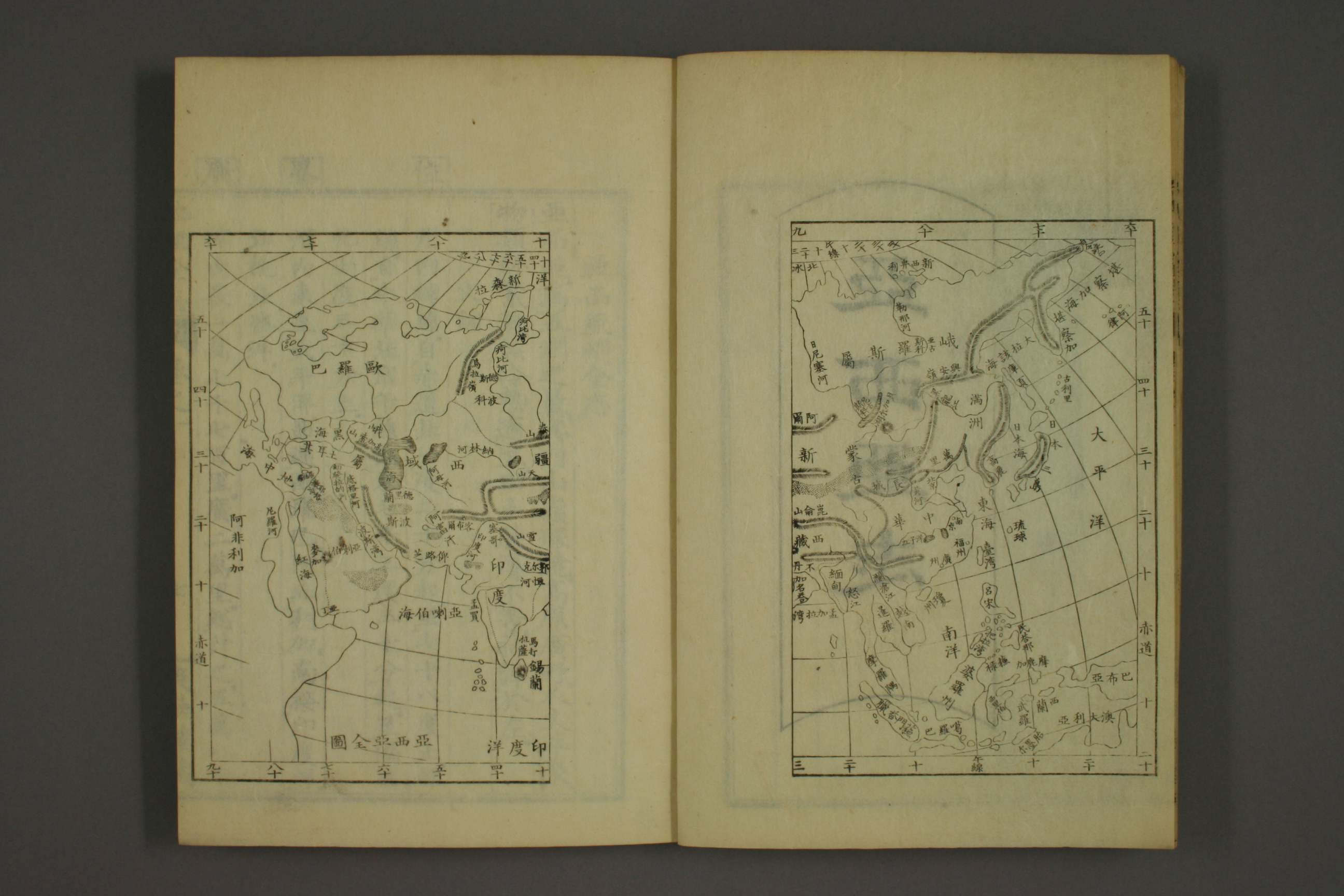
1856-58.Chinese map Sea of Japan and East (China)Sea
地理全志. 上,下編 / 慕維廉 輯訳 - Sea of Japan (日本海)
地理全志 is "All-Geography book" written in China which introduce's european Geography study. They already use the name of "Sea of Japan日本海”, and "East(China)Sea東海”
http://www.wul.waseda.ac.jp/kotenseki/html/ru02/ru02_00168/index.html
Voluome 1 History of Asia
http://archive.wul.waseda.ac.jp/kosho/ru02/ru02_00168/ru02_00168_0001/ru02_00168_0001.html
7/06/2009
1861.China Pilot Third Edidtion King, John W Printed for the Hydrographic Office P379) UK
・1861.China Pilot Third Edidtion King, John W Printed for the Hydrographic Office P379) UK
They use "Sea of Japan", "Strait of Korea" and "Broughton bay"
Chapter 11 Sea of Jpaan,Gulf of Tartary, Gulf and River Amur, Sagharin island, La Perouse strait, and Sea of Okohtuk.
P376
Sea of Japan, is bounded on the east and south by the Japan island, and on the west and north-west by coast of Korea and Tartary. It is about 900 miles long, N.N.E and S.S.W, and 600mileswide, East and West, at its broadest part. Surronded by land on all sides, This sea is only accessible by the following narrow passages:-To the south by the Korea strait, which connect it with the China Sea; to the east by La Perouse and Tsugar straits, by which it communicates with the Pacific; and to the north by the gulf of Tartary ,through which it communicates with the sea of Okhotsuk by the gulf of Amurl. The Boungo and Kino channels which lead into the Suwo nada at the southwest end of Nipon, and the connection of the Suwo Nada with Korea Strait north of kiusiu island, are as yet little known*
Tsus sima, extending about 37 miles in a N.N.E and S.S.W direction, separate the Korean strait into two chanels, the western of which is named Broughton and the eastern Krusenstern. The island is divided into two parts by a large inlet named Tsus sima sound. The southern portion is high and mountainous with two sharp peaks on its northern part, forming like asses( epars when bearing S.E. The northern portion is comparatively low and level, except about one-third from its north-east extreme, where it rises into an high mountain.
M. de Montravel places the south-east point of this island in lat .4"5 1/2N, long. 129"16'E; and Kiku-saki, the south-west point in 34"10'N., 129"10'E.
H.M.S Sylbille, in April 1855, passed through Broughton Channel, between Tsus sima and the Koran coast, and it appeared to be clear of danger on the island side. A dangerous reef was seen extending a mile or more from the south-west point of Tsus simal ad the north east point appeared to terminate in a rocky reef. Captain Forsyth, who passed through Koera strait in H.M.S Hornet, in 1856 , states that Kursenstern channel on the east side of Tsus sima is to be preferred, as it is the widest and less current was experienced in it.
caution- when navigationg Koera strait, the barometer shuold be carefully watched. especially at night, as sudden shifts of wind frequently occur with heavy gusts, which give but little warning of their approach.
P379
The East Coast of Korea , unlike the western coast, is steep-to at a short distance from the shore. A running survey was made by the Russian frigate Pallada in 1854 of its whole extent for about 600miles, from the high detached rocks at the entrance of Chosan harbour to lat. 42"31'N., long . 131"10'E. Port Lezaref, Napoleon road or Posiette harbour, and the Tumen river were surveyed by her boats.
The frigate ahad steady fair winds, and kept at a distance of from one to
4 miles off shore, approaching even nearer at some parts, and following
its windings, The coast has a uniform appearance; sometimes, however,
it changes suddenly; from being mountainous and rocky it becomes low add sandy, assuming its former appearance after a short interval.
P382 (As a part of east coast of Korea)
Broughton Bay-(Korea gulf of the French charts) is 93 miles wide between cape Duroch on the south and cape Petit Thouras on the north, and 55 miles deep, and Yung-hing bay and Port Lezaref at its head offer excellent shelter. The shores of the bay are winding and mostly low, and vessels can anchor in a moderate depth off them with safety.
The north and south shores of Broughton Bay are commanded by lofty heights near the sea. The Belavenz montains, about 15 miles south-west of cape Duroch, are respectively 6.092 and 5.884 feet above the sea; and the north at 24 miles in the interior,W.N.W. of cape Petit Thouras, mout Hienfung reaches the height of 8114 feet. The shores, although wooded and verdant, are varied occassional by waste lands and
rocky cliffs.
After passing Cape Duroch, a moderate sized bay will open out witha low sandy shore, and it probably affords good anchoring ground during southerly winds, as in general all the bays examined on their coast invariably do. A group of small islands and sunken rocks lie in the middle and in north^west parts of this bay; several of the islands have a few cedar trees. From the north extreme of the bay the coast again becomes winding and rocky, and gradually falls toward Feleny point.
By the way South Korean scholor admitted the name of "Sea of Japan" is not Japan's imperiarism or expansionism name, but it is already be established as a grobal standard name around 1861, China Pilot third edition
See here;
- 1861년 China Pilot 제 3판 발행 영국해군성에서는 1850년대말까지 이루어진 우리 나라 주변해역에서의 지리적 지식을 종합하여 1861년 China Pilot 제 3판을 발행했습니다. 이것은 1858년에 나온 제 2판을 수정한 것으로, 독도 연구와 한반도 근해 바다의 명칭을 정리한 것이기에 중요한 문헌입니다. 제 4판은 1864년에 나왔는데, 독도에 관한 기술은 제 3판과 같습니다. 독도가 중요하게 기술된것은 항해에 위험한 장애물이 되기때문이었습니다. 제 2판에서는 독도를 Hornet Islands로 적고 1855년 4월 25일 Hornet호에서 측정한 위치를 북위 37도 14분, 동경 131도 55분으로만 간단히 기록했으나, 제 3판에서는 Liancourt Rocks로 적고 Hornet호 함장 Forsyth의 측정위치와 함께 1849년 Liancourt호에 의해서 알려졌고, 1854년에는 Olivutsa호에 의해서 Menalai and Olivutsa로도 불린다는 사실도 적어놓았습니다. 1861년 출판된 China Pilot 제 3판의 제목은 이고, 총 11장으로 구성되어 있는데, 그중에서 제 7장이 East Coast of China_Whang-Hai or Yellow Sea; Gulfs of Pe-chili and Liau-tung; and West and South Coasts of Korea 입니다. 제 11장은 Sea of Japan; Gulf of Tartary; Gulf and River Amur; Saghlin Island; La Perouse Strait; and Sea of Okhotsk 이며, 여기에 East Coast of Korea가 포함되어 있습니다. 여기서 영어 원문을 그대로 적어놓는것은 국제적 명칭 연구에 참고하기를 바라는 뜻이 담겨있습니다. 한반도의 서해안과 남해안은 아직도 많은곳이 더 조사되어야할 사항으로 남아있지만, 독도와 동해의 국제적 고유명칭 연구에 가장 귀중한 자료중 하나이기에 소개하는 것입니다. 역사적인 유래를 모르고, 게다가 중요한 문헌을 살펴보지도 않고, 의미없는 지도나 해도들을 나열하며 동해의 국제적 명칭을 논하는것은 위험한 일입니다. 동해의 국제적 명칭은 Sea of Japan으로 이미 이 때 굳어졌으며, 그 근원은 La Perouse의 과학적 탐사결과 입니다. 이제 우리가 할 일은 동해를 접하고 있는 연안국 모두가 부르기 좋은 이름으로 고치는 협의 입니다. China Pilot는 중국수로지(中國水路誌)라고 번역할 수 있으며, 동북이시아 해역의 항해안전을 위한 안
1873.China Sea Directory," 1st Edition Vol. 4 (1873) UK
The description of hydrographic magazine by UK admirary office (hidrographic office)
The already Use the global standard name of Sea of Japan. It shows "the name of Sea of Japan" is not the name which Japan forced Korea call it as the result of annexation. So It is confirmed that Korean claim is distorted.
・1873.China Sea Directory," 1st Edition Vol. 4 (1873) UK
http://www.archive.org/details/chinaseadirecto00deptgoog
Chapter 3 Sea of Japan and coast of Korea....
P74
Korea Strait * divides the south-east coast of Korea frm the south-west coast of the Japan islands; it is split into two channels by Tsu shima.
P75
Sea of Japan, bounded on the east and south by the Japan island, and on the west and north-west by coast of Korea and Russian Tartary is about 900 miles long, N.N.E and S.S.W, and 600miles East, and West, at its broadest part. Surronded by land on all sides, This area is only accessible by the following narrow passages:-To the south by the Korea strait, which connect it with the China Sea; to the east by La Perouse and Tsugar straits, by which it communicates with the Pacificland to the north by the gulf of Tartary ,through which it communicates with the sea of Okhotsuk by the gulf of Amurl this area is ,as far as is known, clear of rocks or dangerous with the following exceptions*:
P78
Broughton Bay-(Korea gulf) is 93 miles wide between cape Duroch on the south and cape Petit Thouras on the north, and 55 miles deep, and Yung-hing bay and Port Lezaref at its head offer excellent shelter. The shores of the bay are winding and mostly low, and vessels can anchor in a moderate depth off them with safety.
The north and south shores of Broughton Bay are commanded by lofty heights near the sea. The Belavenz montains, about 15 miles south-west of cape Duroch, are respectively 6.092 and 5.884 feet above the sea; and the north at 24 miles in the interior,W.N.W. of cape Petit Thouras, mout Hienfung reaches the height of 8114 feet. The shores, although wooded and verdant, are varied occassional by waste lands and
rocky cliffs.
7/02/2009
Korean use the name of Sea of Japan before annexatoin.
Korean use Sea of Japan before annexatoin on 1910 on their documents;
1890.03.25
總關公文 督辦統理交涉通商事務 閔(1890년 3월 25일) → 署理總稅務司 史
현재 日本海에서 哥麥魯舡에 搭付한 大掛鏡 2面裝 1件 및 본국 廣濟舡에 搭付한 紬緞‚ 洋燭 등 각종 합계 14件이 仁川港에 到泊해 있는데‚ 署理總稅務司가 仁川稅務司에게 轉飭하여 모두 免稅 放行하게 하라는 關文.
現在日本海で哥麦魯〓に搭付ある大掛鏡2面装1件および本国広済〓に搭付ある紬緞? 洋燭など各種合計14件が仁川港に到泊しているが? 署理総税務司が仁川税務司に転飭して,皆免税放行するようにしろとの関文.
1895 Joseonjisi 朝鮮地誌(Korea Geography)
The description of Chosun Jiji朝鮮地誌, edit and published by Education editor Bureau学部編纂局 on 1895.
Chosun is located on the eastern part of Asia , faced with Sea of Japan on the Southeast, west with Yellow sea, north with River Abnok and Duman鴨緑豆満.
朝鮮は亜細亜州の東端に在り東南は日本海に面し、西は黄海に臨み、北は鴨緑豆満二江・・・・

1899.海東志
(Quote from Kyuujanggak website:<江河>항목에서 豆滿江을 국경하천으로 소개하지 않고 5대강의 하나로만 서술한 것으로 볼 때 19세기 말 20세기 초에 우리나라의 역사지리에 대한 관심이 높아져 가고 있었던 사상적 분위기를 반영하는 것으로 추정된다. 그러나 東海를 ‘日本海’라고 표기하는 등 표현상 혼란이 나타나므로 편찬주체나 목적에 대해서는 명확히 단정하기는 어렵다. (정재훈)
)
1899-1906 Daehanjisi大韓地誌 【Great Korean Geography (official)
Daehanjiji大韓地誌,also published by Education editor Bureau学部編纂局 from 1899-1906.
Chosun(Korea) locates on the eastern part of Asia, at NorthEast of China, between Sea of Japan and Yellow Sea, Bolhae. It is peninsula country. ………….
East part facing with Sea ofJapan , West with Yellwow sea, south with Sea of Japan …………………..
朝鮮は亜細亜州の東端に在り支那の東北部XXX日本海X黄海渤海間X突出半島国
(中略)東X日本海X界XX西は黄海X濱XX南X日本海X黄海X挑XX東南X一海峡X隔XX日本対馬島

Above those two famous Korean textbook also uses Sea of Japan. It is not only textbook which use Sea ofJapan but also many variety of Great Korean Imperial’s official document and Newspaper in Korea Sea of Japan in various documents: check here ( By Nidanosuke).
1904.03.08 皇城新聞 日本海○의 倚例
1904.05.17.照會 第十二號
http://db.history.go.kr/front/srchservice/srcFrameSet.jsp?pSearchWord=65E5672C6D77&pSearchWordList=65E5672C6D77&pSetID=-1&pTotalCount=0&pSearchType=1&pMainSearchType=2&pQuery=002800420049003A002865E5672C6D7700290029&pSearchClassName=&oid=&url=&method=&lang=&code=&searchword=&return=
米蕯照會于咸興觀察使譯本 太平時節에 日本海에 셔 京城咸興水邊으로 俄國으로 韓國淸國여음와 物貨을 싯고 녈믐어간의 出入엿오며 至今日本과 開戰되엿기로 俄國軍隊官人더리 分付잇셔 日本軍盤이올가여 俄國浦口마다 水雷砲을 심젓오며 其水雷砲오디 아니옵고 만일 닷치은즉 砲發와 時刻의 며 군안물여 살암을 다쥬길터이오며 貴觀察使分付여 船主人덜어 操心게 오며 患難읍게 오며 장 船到泊 時을 定여 浦口마다 法程을 約條오면 貴쳐로 알계터외다 海蔘葳浦口에셔 晝則船이 東邊에셔만 出入게고 且若夜에 船이 任意로 出入즉 水雷砲을 노며 大砲로 노와읍시터이오며 大俄國一千九百四年三月十二日大俄國交界官廓米蕯封書.
1906.09.25.대한자강회월보 제3호 http://www.history.go.kr/url.jsp?ID=NIKH.DB-ma_01_003_0080
○ 我國은 亞細亞 東部의 一半島國이라. 西北은 滿洲와 遼東과 土壤을 接고 西 黃海를 限야 淸國의 山東省과 隣고 南은 朝鮮海峽을 臨고 東은 日本海와 接고 東北은 土門江을 限야 淸國의 吉林省과 俄 領海蔘威 地帶와 近야 三面에 環海이 島國과 如으로 半島라 稱나니라. 起北緯三十三度三十五分야 止四十二度卄五分고 起東經百二十四度三十分야 止百三十度三十五分니 面積이 約八萬二千方英里오 南北의 長은 三千六百餘里오 東西의 廣은 或 千餘里 或 六七百里니 此 現今 疆土之大略也라.
日本海의 大危險
1906.1907 日本海의 大危險 万歳報 만세보
1906.12.18.議政府 照會 第二百八十六號 內部
http://db.history.go.kr/front/srchservice/srcFrameSet.jsp?pSearchWord=65E5672C6D77&pSearchWordList=65E5672C6D77&pSetID=-1&pTotalCount=0&pSearchType=1&pMainSearchType=2&pQuery=002800420049003A002865E5672C6D7700290029&pSearchClassName=&oid=&url=&method=&lang=&code=&searchword=&return=
現接統監府來文온즉 內開에 日本海及 其他沿海에 機械水雷가 浮流야 艦船航行에 危險이 不尠 아니라 種種陸岸에 漂着야 發見者가 處置上에 過誤을 因야 不意의 危害 發生 虞가 有 바 此次帝國政府에셔 其危險을 除去기 爲야 水雷發見者에 一定 金圓을 給與기로고 仍히 浮流水雷處置 注意方法을 定야 客月二十二日遞信省告示第五百八號로 公布 바 貴國沿海에 浮流 機械水雷危險除去에 關야 貴國政府어셔도 相當히 措置심을 爲要等因이온 바 査此水雷機械가 浮流海面야 不時危害 亦難預度이기 爲其參考야 日本遞信省告示 謄附照會오니 照諒신後 撮要措辭야 沿海人民으로 過有此等種類어든 極加注意에 免致危險도록 發訓沿海各郡심을 爲要. 議政府參政大臣 朴齊純 內部大臣臨時署理農商工部大臣 成岐運 閣下 議政大臣 參贊 秘書課長 參政大臣 局長 調査課長 課員 光武十年十二月十八日 光武十年十二月十八日 裁定 課員
1907.大韓新地誌 (Korean imperial new geography)
第二章 位置
我國○位置○亜細亜州○東部○在○○支那大陸○北東部○○○渤海○黄海○日本海○間○突出○楯長○半島國○○其極南○地....................

1907.06.25.대한자강회월보 제12호 http://www.history.go.kr/url.jsp?ID=NIKH.DB-ma_01_012_0080
第二에 最有興味 事 今日에 至야 大韓國과 日本이 分離야 中間에 朝鮮海峽이라 大海가 介在얏스나 上古時代에 兩國이 連陸얏던 確證을 地質學者의 硏究 結果로 引出지라 此 問題가 二十八九年前브터 學者의 注意를 惹起얏 日本各地에셔 象骨 象牙 象齒를 掘出 原因을 推究즉 元來 上古에 北亞細亞大 陸에 象이라 動物이 繁殖얏고 此 動物은 海中에 游泳치 못 其骨與齒를 日本에서 掘出얏슨 則 大韓과 日本이 連陸되엿던 것을 可知겟도다. 且 日本人 岡材博士가 日本沿海의 海草를 硏究 則 太平洋 方面에는 海草의 種類가 多고 日本海方面에 少을 發見지라 此로 推見더도 日本海가 太平洋에 比較면 海 成 年度가 頗淺을 證明겟고 又 太平洋方面은 水深이 六千尺에 達 處가 有고 日本海方面은 一帶甚淺야 平均 百尺에 過치 못니 以上海草와 海深의 二件을 依야 査考야도 最初에 大韓과 日本一陸地를<24>成얏다가 後來에 滄桑이 一幾야 日本海가 出來으로 兩國이 分離야 今日 地形을 成것은 明暸고 最近 日本 農商務省 地質調査所에셔 調査 바 據則 長門國最西北端에 在 嶋嶼의 岩層은 老花岡巖層 中에 新時代의 靑石岩層과 類似을 發見얏스니 此等 奇異 現象이 大韓國南岸(卽 釜山附 近 一帶沿岸)에 散在 것을 見더도 大韓과 日本이 古昔時代에 連續되엿던 證跡이 分明고 韓日兩國이 上古時代에 果然 連陸얏슬 것 트면 其 鑛物의 散布 狀態가 類似치 아니타 수 업 故로 今日에 至토록 韓國의 鑛物 散布 狀態를 硏究며 調査 中인 其 調査表를 不遠間에 公佈려니와 其 槪略을 據 則 大韓國 黃金과 石炭의 含有量은 日本에 比較면 非常히 多量것신 確實도다. 金鑛으로 言면 雲山과 如 大鑛山이 定然히 星羅碁置얏슬 것이요 石炭鑛으로 言더도 將來에 大段히 繁榮야 不可勝用 것이라 抑 夫 石炭은 上古時代의 植物이 地中에 埋沒야 炭素를 殘留인 故로 炭田 所在地에 반다시 該 時代의 植物化石이 存在겟고 換言면 草類化石과 針葉樹 化石이 岩層 中에 發見된 地方에 炭田이 確有니 蓋 日本築豊炭田으로 推見면 世界萬國의 炭田이 皆然겟고 近日 平壤에셔 採掘 無烟炭田에도 同一 結果로 岩層上 數尺地에 往往히 前記의 植物化石이 存在얏스니 其 炭田의 面積이 狹隘고 又 木浦 群山 方面에도 前記의 植物岩石을 發見 人이 有니 各 地方에 在 炭田를 以 此 等 方法으로 注目면<25>將來에 盡爲發見려니와 特이 京釜線路 兩側으로 言면 其 東側에 該 植物과 化石의 發見이 夥多야 其 範圍 大凡 慶尙南道 全部를 包含얏고 又 北道一部지 犯入얏슨즉 慶尙南道 一大 炭田이라 其 面積를 考면 日本의 築豊炭田브다 較大나 但 此를 試掘치 못얏고 又 情密히 調査치 못으로 同地에셔 如何 性質의 石炭이 如何 狀態로 散布얏지 尙 不明瞭지라 平壤地方의 無烟炭田과 同樣의 植物化石이 有데셔 數尺下에 及면 炭田이 有듯 며 近日 慶州 附近에셔 一大 無炭田이 有다고 傅 者ㅣ 有니 此 言이 必非虛誕일듯 며 以上의 硏究 것과 昨今年中의 調査 바를 據더도 慶尙南道 將來의 炭田事業으로 由야 有利有望 一大富源이 될쥴노 確證을 立노라. 大槪 各道의 主要 鑛物을 調査즉 左와 如니라.
1908.02.25 http://db.history.go.kr/url.jsp?ID=ma_09_001_0040
1908.10.25. http://db.history.go.kr/url.jsp?ID=ma_05_003_0180
大韓新地理學 (第一編 地文地理 )
金夏鼎
1908.12.01
http://db.history.go.kr/url.jsp?ID=ma_04_007_0110
http://db.history.go.kr/url.jsp?ID=ma_04_008_0050
大韓商業地理
1890.03.25
總關公文 督辦統理交涉通商事務 閔(1890년 3월 25일) → 署理總稅務司 史
현재 日本海에서 哥麥魯舡에 搭付한 大掛鏡 2面裝 1件 및 본국 廣濟舡에 搭付한 紬緞‚ 洋燭 등 각종 합계 14件이 仁川港에 到泊해 있는데‚ 署理總稅務司가 仁川稅務司에게 轉飭하여 모두 免稅 放行하게 하라는 關文.
現在日本海で哥麦魯〓に搭付ある大掛鏡2面装1件および本国広済〓に搭付ある紬緞? 洋燭など各種合計14件が仁川港に到泊しているが? 署理総税務司が仁川税務司に転飭して,皆免税放行するようにしろとの関文.
1895 Joseonjisi 朝鮮地誌(Korea Geography)
The description of Chosun Jiji朝鮮地誌, edit and published by Education editor Bureau学部編纂局 on 1895.
Chosun is located on the eastern part of Asia , faced with Sea of Japan on the Southeast, west with Yellow sea, north with River Abnok and Duman鴨緑豆満.
朝鮮は亜細亜州の東端に在り東南は日本海に面し、西は黄海に臨み、北は鴨緑豆満二江・・・・
1899.海東志
(Quote from Kyuujanggak website:<江河>항목에서 豆滿江을 국경하천으로 소개하지 않고 5대강의 하나로만 서술한 것으로 볼 때 19세기 말 20세기 초에 우리나라의 역사지리에 대한 관심이 높아져 가고 있었던 사상적 분위기를 반영하는 것으로 추정된다. 그러나 東海를 ‘日本海’라고 표기하는 등 표현상 혼란이 나타나므로 편찬주체나 목적에 대해서는 명확히 단정하기는 어렵다. (정재훈)
)
1899-1906 Daehanjisi大韓地誌 【Great Korean Geography (official)
Daehanjiji大韓地誌,also published by Education editor Bureau学部編纂局 from 1899-1906.
Chosun(Korea) locates on the eastern part of Asia, at NorthEast of China, between Sea of Japan and Yellow Sea, Bolhae. It is peninsula country. ………….
East part facing with Sea of
朝鮮は亜細亜州の東端に在り支那の東北部XXX日本海X黄海渤海間X突出半島国
(中略)東X日本海X界XX西は黄海X濱XX南X日本海X黄海X挑XX東南X一海峡X隔XX日本対馬島
Above those two famous Korean textbook also uses Sea of Japan. It is not only textbook which use Sea of
1904.03.08 皇城新聞 日本海○의 倚例
1904.05.17.照會 第十二號
http://db.history.go.kr/front/srchservice/srcFrameSet.jsp?pSearchWord=65E5672C6D77&pSearchWordList=65E5672C6D77&pSetID=-1&pTotalCount=0&pSearchType=1&pMainSearchType=2&pQuery=002800420049003A002865E5672C6D7700290029&pSearchClassName=&oid=&url=&method=&lang=&code=&searchword=&return=
米蕯照會于咸興觀察使譯本 太平時節에 日本海에 셔 京城咸興水邊으로 俄國으로 韓國淸國여음와 物貨을 싯고 녈믐어간의 出入엿오며 至今日本과 開戰되엿기로 俄國軍隊官人더리 分付잇셔 日本軍盤이올가여 俄國浦口마다 水雷砲을 심젓오며 其水雷砲오디 아니옵고 만일 닷치은즉 砲發와 時刻의 며 군안물여 살암을 다쥬길터이오며 貴觀察使分付여 船主人덜어 操心게 오며 患難읍게 오며 장 船到泊 時을 定여 浦口마다 法程을 約條오면 貴쳐로 알계터외다 海蔘葳浦口에셔 晝則船이 東邊에셔만 出入게고 且若夜에 船이 任意로 出入즉 水雷砲을 노며 大砲로 노와읍시터이오며 大俄國一千九百四年三月十二日大俄國交界官廓米蕯封書.
1906.09.25.대한자강회월보 제3호 http://www.history.go.kr/url.jsp?ID=NIKH.DB-ma_01_003_0080
○ 我國은 亞細亞 東部의 一半島國이라. 西北은 滿洲와 遼東과 土壤을 接고 西 黃海를 限야 淸國의 山東省과 隣고 南은 朝鮮海峽을 臨고 東은 日本海와 接고 東北은 土門江을 限야 淸國의 吉林省과 俄 領海蔘威 地帶와 近야 三面에 環海이 島國과 如으로 半島라 稱나니라. 起北緯三十三度三十五分야 止四十二度卄五分고 起東經百二十四度三十分야 止百三十度三十五分니 面積이 約八萬二千方英里오 南北의 長은 三千六百餘里오 東西의 廣은 或 千餘里 或 六七百里니 此 現今 疆土之大略也라.
日本海의 大危險
1906.1907 日本海의 大危險 万歳報 만세보
1906.12.18.議政府 照會 第二百八十六號 內部
http://db.history.go.kr/front/srchservice/srcFrameSet.jsp?pSearchWord=65E5672C6D77&pSearchWordList=65E5672C6D77&pSetID=-1&pTotalCount=0&pSearchType=1&pMainSearchType=2&pQuery=002800420049003A002865E5672C6D7700290029&pSearchClassName=&oid=&url=&method=&lang=&code=&searchword=&return=
現接統監府來文온즉 內開에 日本海及 其他沿海에 機械水雷가 浮流야 艦船航行에 危險이 不尠 아니라 種種陸岸에 漂着야 發見者가 處置上에 過誤을 因야 不意의 危害 發生 虞가 有 바 此次帝國政府에셔 其危險을 除去기 爲야 水雷發見者에 一定 金圓을 給與기로고 仍히 浮流水雷處置 注意方法을 定야 客月二十二日遞信省告示第五百八號로 公布 바 貴國沿海에 浮流 機械水雷危險除去에 關야 貴國政府어셔도 相當히 措置심을 爲要等因이온 바 査此水雷機械가 浮流海面야 不時危害 亦難預度이기 爲其參考야 日本遞信省告示 謄附照會오니 照諒신後 撮要措辭야 沿海人民으로 過有此等種類어든 極加注意에 免致危險도록 發訓沿海各郡심을 爲要. 議政府參政大臣 朴齊純 內部大臣臨時署理農商工部大臣 成岐運 閣下 議政大臣 參贊 秘書課長 參政大臣 局長 調査課長 課員 光武十年十二月十八日 光武十年十二月十八日 裁定 課員
1907.大韓新地誌 (Korean imperial new geography)
第二章 位置
我國○位置○亜細亜州○東部○在○○支那大陸○北東部○○○渤海○黄海○日本海○間○突出○楯長○半島國○○其極南○地....................

1907.06.25.대한자강회월보 제12호 http://www.history.go.kr/url.jsp?ID=NIKH.DB-ma_01_012_0080
第二에 最有興味 事 今日에 至야 大韓國과 日本이 分離야 中間에 朝鮮海峽이라 大海가 介在얏스나 上古時代에 兩國이 連陸얏던 確證을 地質學者의 硏究 結果로 引出지라 此 問題가 二十八九年前브터 學者의 注意를 惹起얏 日本各地에셔 象骨 象牙 象齒를 掘出 原因을 推究즉 元來 上古에 北亞細亞大 陸에 象이라 動物이 繁殖얏고 此 動物은 海中에 游泳치 못 其骨與齒를 日本에서 掘出얏슨 則 大韓과 日本이 連陸되엿던 것을 可知겟도다. 且 日本人 岡材博士가 日本沿海의 海草를 硏究 則 太平洋 方面에는 海草의 種類가 多고 日本海方面에 少을 發見지라 此로 推見더도 日本海가 太平洋에 比較면 海 成 年度가 頗淺을 證明겟고 又 太平洋方面은 水深이 六千尺에 達 處가 有고 日本海方面은 一帶甚淺야 平均 百尺에 過치 못니 以上海草와 海深의 二件을 依야 査考야도 最初에 大韓과 日本一陸地를<24>成얏다가 後來에 滄桑이 一幾야 日本海가 出來으로 兩國이 分離야 今日 地形을 成것은 明暸고 最近 日本 農商務省 地質調査所에셔 調査 바 據則 長門國最西北端에 在 嶋嶼의 岩層은 老花岡巖層 中에 新時代의 靑石岩層과 類似을 發見얏스니 此等 奇異 現象이 大韓國南岸(卽 釜山附 近 一帶沿岸)에 散在 것을 見더도 大韓과 日本이 古昔時代에 連續되엿던 證跡이 分明고 韓日兩國이 上古時代에 果然 連陸얏슬 것 트면 其 鑛物의 散布 狀態가 類似치 아니타 수 업 故로 今日에 至토록 韓國의 鑛物 散布 狀態를 硏究며 調査 中인 其 調査表를 不遠間에 公佈려니와 其 槪略을 據 則 大韓國 黃金과 石炭의 含有量은 日本에 比較면 非常히 多量것신 確實도다. 金鑛으로 言면 雲山과 如 大鑛山이 定然히 星羅碁置얏슬 것이요 石炭鑛으로 言더도 將來에 大段히 繁榮야 不可勝用 것이라 抑 夫 石炭은 上古時代의 植物이 地中에 埋沒야 炭素를 殘留인 故로 炭田 所在地에 반다시 該 時代의 植物化石이 存在겟고 換言면 草類化石과 針葉樹 化石이 岩層 中에 發見된 地方에 炭田이 確有니 蓋 日本築豊炭田으로 推見면 世界萬國의 炭田이 皆然겟고 近日 平壤에셔 採掘 無烟炭田에도 同一 結果로 岩層上 數尺地에 往往히 前記의 植物化石이 存在얏스니 其 炭田의 面積이 狹隘고 又 木浦 群山 方面에도 前記의 植物岩石을 發見 人이 有니 各 地方에 在 炭田를 以 此 等 方法으로 注目면<25>將來에 盡爲發見려니와 特이 京釜線路 兩側으로 言면 其 東側에 該 植物과 化石의 發見이 夥多야 其 範圍 大凡 慶尙南道 全部를 包含얏고 又 北道一部지 犯入얏슨즉 慶尙南道 一大 炭田이라 其 面積를 考면 日本의 築豊炭田브다 較大나 但 此를 試掘치 못얏고 又 情密히 調査치 못으로 同地에셔 如何 性質의 石炭이 如何 狀態로 散布얏지 尙 不明瞭지라 平壤地方의 無烟炭田과 同樣의 植物化石이 有데셔 數尺下에 及면 炭田이 有듯 며 近日 慶州 附近에셔 一大 無炭田이 有다고 傅 者ㅣ 有니 此 言이 必非虛誕일듯 며 以上의 硏究 것과 昨今年中의 調査 바를 據더도 慶尙南道 將來의 炭田事業으로 由야 有利有望 一大富源이 될쥴노 確證을 立노라. 大槪 各道의 主要 鑛物을 調査즉 左와 如니라.
1908.02.25 http://db.history.go.kr/url.jsp?ID=ma_09_001_0040
| 大韓學會創立序 (대한학회창립서) 金基敬 |
| 隆熙元年冬東遊之學生諸人唱論學會之說越明年正月上旬會于日本 東京 麴町區我大韓留學生監督部公堂之東廡協採衆議公佈規則於是乎大韓學會之名立矣再會而掌理庶務確立制度大韓學會之事又幾整理矣從玆以往繼繼相會而大韓學會之志亦可得以達矣豈非學界之大幸耶然學會之名旣立矣學會之事旣整理矣而不能達其學會之志則名義焉而已事爲焉而巳亦何足爲幸也哉然則學會之志安在而學會之志又將何以能達也惟我. |
| 大韓臨亞洲之極東 ―起於東徑線百二十四度三十分至於百三十度三十五分實犬陸之極東也― 北通大陸三面蒼海 ―北接淸國 吉林 盛京兩省東濱日本海西臨勃海 黃海南隔海峽而遠望太平洋― 三千里疆土 ―面積大約八萬二千方英里― 非不廣也二千萬人民 ―人口約一千五百萬― 非不衆也且淑氣育精 ―起於北緯線三十三度十五分至於四十二度二十五分近於北溫帶中萬氣序調暢― 人文早開政敎文物未始不章章可觀矣自萬國交通之後天下之風氣大變各尙功利各圖富强龍蟠虎視於大陸東西者磊落相望生存競爭優勝劣敗朝聘玉帛夕尋干戈此何日也此何時也而顧我. |
| 大韓昇平日久文治漸弱士氣萎靡民志頹怠閉關自守不肯振作海外戰雲看作壁上之畵國內士風甘守桃園之夢噫東晋之淸談能攘五胡之强侵耶由是國威日墜外侮日甚宗社生靈之禍乃至今日嗚呼痛矣嗚呼慘矣痛哭流涕何待賈生而後然哉何幸挽近以來迷雲漸釋新運胚萌上自. |
| 朝家下至閭閻莫不派送子弟遊學外洋臨其出彊父兄故舊送之以言曰堅乃志氣勉爾學問以爲他日國家之棟樑以爲他日國民之標<5>範無負吾今日送汝之意也其責任之重期待之遠果何如哉而敢不猛省自勵夙夜孜孜乎然則吾儕之所當勉者學問也所當勵者志氣也斷斷一心豈有他哉雖然明鏡不能自照山石可以攻玉必湏友朋之講磨責輔然後庶免錯誤此會之所以設也曾子曰以文會友以友輔仁夫會之不以文其會也雜友而不輔仁其友也非所謂友也吾儕之會亦當取法於曾子會之以學而輔之以仁則可也然曾子之所謂文非詞章訓話之文而乃修齊治平之文所謂仁非孑孑煦煦之仁而乃洪毅遠大致君澤民之仁也天下之所謂道者豈有大於此者乎凡吾學界諸友母使聖人之言徒作紙上空文實行其事學心理倫理者實踐其理學政治法律者實遂其事學工商者實行其業學理化者實闡其變化以至兵術農藝醫藥畜産莫不實究實行則卽所謂修齊治平之學而致君澤民之道也天下豈有二道哉吾儕當以是爲學而孜孜爲力焉以其暇日會之一所聚首講論知識相長德業相勸以修其輔仁之道輯其所聞述其所見以告我內國同胞敢效其警鐸之意雖涓埃之報以爲他日祖國盡力則庶答其責任期待之萬一而會之志亦可得以達矣向所謂大幸者此也雖然凡吾學界諸友遠離祖國重涉海洋吾之所處山川風物非吾韓土吾之所接被衣戴冠非吾韓人而只與學界諸友携手相從於天涯海濱而曰大韓學界者無乃迂耶但其精神氣魄不關土地之遠近不拘人族之多寡而人人腦髓皆有大韓則雖一二人相會而曰大韓會亦可也況學生之多達於近千乎此會之所以名也若其會之沿革及分合自有舊報不必更贅於此略述其所感以告我同憾之學友亦以告我內國同胞焉不以人廢言則述者之幸也.<6> |
1908.10.25. http://db.history.go.kr/url.jsp?ID=ma_05_003_0180
大韓新地理學 (第一編 地文地理 )
金夏鼎
| 第一章 名稱 |
| 我國이 原住民族時代에 一定 名稱이 無더니 檀君이 起샤 平壤에 定都시고 國號를<29>朝鮮이라 定시다. 此 時代 我國의 區域은 滿洲奉天省의 東部로브터 現今 黃海道 江原道 以北의 地며 京畿道 以南에 馬韓 辰韓 卞韓(所謂 三韓)의 三國이 有더니 高麗 太祖 王建이 此를 統合야 今 開城에 定都고 國號를 高麗라 改稱(西曆 九四二年)다가 王氏가 亡 後에 我 |
| 太祖高皇帝셔 繼天立極사 今 漢陽에 定都시고 國號를 更히 朝鮮(朝日이 鮮明다 意義를 取이라)이라 稱시니 其後 聖子神孫이 繼繼承承시고 現我 |
| 聖天子ㅣ 卽位사 萬國과 獨立을 會盟시고 更히(一八九七年)國號를 改사 大韓(韓은 方言에 一이니 統一다 意義를 取이라)이라 稱시니라. |
| 此外에도 上古에 新羅 或은 高句麗 等의 各種 名稱이 有얏스나 記載 必要가 無으로 本書에 省略나 現今 歐米人 等은 我國을 코리아라 名稱니 此 高麗라 云 言이니라. |
| 第二章 位置 |
| 我大韓國 位置 亞細亞洲의 東部에 在야 支那大陸의 東南端에셔 南方으로 狹長게 突出 半島國이라. 其 極南의 地 濟州鳥의 毛瑟浦니 北緯 三十三度四十六分(六十秒를 一分이라 云고 六十分을 一度라 云니 一度의 長은 約二百十二里라)에 當고 極北의 地 豆滿江 沿岸의 永遠近傍이니 北緯 四十三度二分에 當며 極西 黃海道 長淵郡의 長山串(或 平安道 龍川郡의 龍川浦라 云홈)이니 東經 百二十五度五分에 當고 極東은 露國과 境界되 豆滿江口니 東經 百三十五度五十八分에 當지라. 故로 我國은 其 全域이 此 溫帶中에 在니라.<30>(我國大陸의 極南은 全羅道 莞島의 西南에 在 達陵角이니 北緯 三十四度五十五分에 當니라) |
| 第三章 境界 |
| 我國은 東西 及 南面이 日本海에 臨고 其 南端의 海角이 日本 對馬島와 相對야 海峽을 成 處 卽 朝鮮海峽이라 此를 日本人이 西水道(부롱돈 海峽)라 云니 此間의 距離 二百十四里에 不過며 西南은 黃海에 枕야 支那에 山東省, 江蘇省과 遙遙 相對고 北方大陸에 連 部分은 河流及山脈을 因야 自然的 境界를 成니 卽, 支那와 鴨緣江 及 長白山(不咸山)脈을 因야 割界되얏스며 露領 烏蘇里와 豆滿江을 因야 劃界되얏니라.(未完)<31> |
1908.12.01
http://db.history.go.kr/url.jsp?ID=ma_04_007_0110
http://db.history.go.kr/url.jsp?ID=ma_04_008_0050
大韓商業地理
| 大韓商業地理 (대한상업지리) |
| ○ 位置 我大韓帝國은 亞細亞大陸의 東部에 位야 狹長 一半島와 數多 島嶼로부터 成 者인 日本의 西方에 當고 支那北部의 東隅와 西伯利亞의 東南隅로부터 南方에 突出야 日本海와 黃海 二分다. |
| ○ 境界 西 黃海 隔야 支那東部의 山東 江蘇 兩省에 對고 北은 鴨綠江 長白山脈 及 豆滿江의 一部로써 滿洲의 奉天 吉林 兩省에 接고 南은 朝鮮海峽을 隔야 日本의 九州 及 五島에 對고 東은 日本海에 臨니라. |
| ○ 廣袤 極北은 北緯 四十二度二十五分되 豆滿江口의 沿岸 鹿島 一點에셔 起야 南으로 北緯 三十三度十五分되 濟州島의 毛瑟浦에 達고 西 東經 百二十四度三十分되 小乳纛角으로부터 東은 東經 百三十度三十五分되 豆滿江口에 達 南北은 緯度가 凡 九度二千五百里오 東西 凡 六百里로셔 總面積은 約 八萬二千英方哩 ―我里로 十三萬四百餘方里― 假量이라. |
| ○ 人口 我國은 古來로 精確 調査가 無으로써 諸家의 計算이 區區야 或은 一千萬이라. 或은 一千五百萬이라 或은 二千萬이라<26>稱야 何說을 準信넌지 不知나 多數로 測算 者 卽 最後의 二千萬인 故로 本邦의 人口數 大略 二千萬名으로 算定 者라. 其他 外國人의 居住 者도 亦 不少나 其 中 支那人이 二三千名이오 日本人이 十萬餘名 假量이 되나니라. |
| ○ 地勢 滿洲의 東方에 蔓延 長白山脈은 國의 北境을 限界고 更히 南方으로 一大支脈을 生니 卽 本邦의 東南으로 駛走 大關嶺의 山脈인 此 山脈으로부터 更히 數多 支脈을 生야써 國中에 連亘 故로 到處에 險高 山陵이 起伏고 廣闊 原野가 稀少나니 大關嶺의 山脈은 國의 中央部 縱貫치 아니고 其 山軸이가 頗히 東方으로 偏斜야 南走고 極北에 在야 凡 正南으로 走야 北緯 四十度로 三十七度지 東岸으로 偏斜야 南東으로 走고 三十七度에셔 更히 西南으로 沿走야 一屈折을 生얏스니 大抵 本邦의 地勢 其 山脈의 趨向으로 從야 成 者라. 大關嶺山脈의 中軸은 東方으로 偏斜으로써 地勢가 東方에 急唆고 西方에 緩斜 故로 江流에 大 者 東方에 一豆滿江 有고 西南方에 鴨綠江 同江, 漢江, 錦江, 洛東江, 榮山江 等이 有며, 海岸線도 東方에 屈折이 甚少야 僅히 慶興, 德源, 延日 等의 三灣 有나 西方에 其 屈曲 處가 頗多야 港灣이 無數고 島嶼가 甚衆니 卽 釜山, 木浦, 仁川, 群山, 馬山, 甑南浦 等의 良港과 濟州, 巨濟, 珍島, 莞島, 智島 等의 大島가 有名지라. 地勢上으로 如斯 東西의 差別가 有과 갓치 人文地理上에 在야도 兩面의 差異가<27>甚야 西部 東部보다 人口가 稠密고 物産이 豊富고 商業이 殷盛을 可히 測知지라.<28> |
| <26-28> |
6/13/2009
1736.Royaulme de Coree. Dh halde.
Description géographique, historique, chronologique, politique, et physique de l'empire de la Chine et de la Tartarie chinoise, enrichie des cartes générales et particulieres de ces pays, de la carte générale et des cartes particulieres du Thibet, & de la Corée; & ornée d'un grand nombre de figures & de vignettes gravées en tailledouce (1736)
Although D'anville's Carte de Royaulme de Coree describes "Mer du Coree" on east coast of Corean Peninsula, they use "Mer Du Japon(Sea of Japan) on the artiles.Volume Ⅳ Royaulme de Coree
PDF P170 http://www.archive.org/details/descriptiongog04duha
Après avoir fait ces 8o. lys à l'Eft, nous trouvâmes que la valée s'élargiflbit
confidérablement, 6c qu'elle formoit une plaine de plus d'une lieue
de diamètre. Nous traversâmes cette plaine en tournant vers leNord-Oueil,
6c nous pafsâmes la rivière : nous vîmes fur fes bords quantité de grofles pièces
de bois propres à bâtir, la plupart defapin: on les fait defcendre fur
cette rivière dans le tems qu'elle eft le plus fournie d'eau jufques vers la mer
du Japon: puis on les tranfporte dans une autre rivière, & en les faifant
floteriur l'eau, on les conduit jufqu'à une journée de Peking. C'eif ce qui
fait que le bois à bâtir n'y eft pas cher, quoiqu'il s'en fifle une grofle confommation
, parceque les charpentes des maifons font extrêmement fournies.
PDF 538
A Corée , qu'on peut appeller avec raifon la Cherfonefe de la Chine , puifqu'elle lui efi: contigue & triburaire, eftune grande peninfule qui s'avance en forme de cap dans la Mer orientale, entre la Chine & le Japon. La Mer du Japon la baigne à l'Orient ; le Golphe de Leao tong la fépare des Provinces de Pé tche li & de Chan tong du côté de l'Occident. Au Nord elle confine avec le pays
deNiutche (a) : elle a la grande Mer au Midi; & le fleuve Ta lou, qui la borne entre l'Occidentl & le Nord, & la diflingue du Leao tong. Elle a I200. lys {h) d'étendue d'Orient en Occident, & deux-mille-deuxà trois-cens lys du Septentrion au Midi.
La Corée a été autrefois la demeure de différens peuples , dont les principaux étoient les Mé , les Kao kiuli , les Han , & ces derniers fe partageoient encore en trois efpeces : fçavoir les Ma han , les Pien han , ..................
登録:
コメント (Atom)


